Maps of Wiltshire
Wiltshire LXXIV.NE - OS Six-Inch Map
1 : 10560 Topographic maps Ordnance Survey Ordnance Survey
Wiltshire LXXIV.NE - OS Six-Inch Map
1 : 10560 Topographic maps Ordnance Survey Ordnance Survey
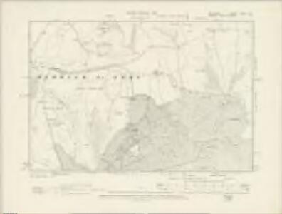
Wiltshire LXXIV.3 (includes: Berwick St John; Tollard Royal) - 25 Inch Map
1 : 2500 Topographic maps Ordnance Survey Ordnance Survey
Wiltshire LXXIV.3 (includes: Berwick St John; Tollard Royal) - 25 Inch Map
1 : 2500 Topographic maps Ordnance Survey Ordnance Survey
Wiltshire LXXIV.3 (includes: Berwick St John; Tollard Royal) - 25 Inch Map
1 : 2500 Topographic maps Ordnance Survey Ordnance Survey
Wiltshire LXXIV.4 (includes: Alvediston; Berwick St John; Ebbesbourne Wake) - 25 Inch Map
1 : 2500 Topographic maps Ordnance Survey Ordnance Survey
Wiltshire LXXIV.4 (includes: Alvediston; Berwick St John; Ebbesbourne Wake) - 25 Inch Map
1 : 2500 Topographic maps Ordnance Survey Ordnance Survey
Wiltshire LXXIV.4 (includes: Alvediston; Berwick St John; Ebbesbourne Wake) - 25 Inch Map
1 : 2500 Topographic maps Ordnance Survey Ordnance Survey
Wiltshire LXXIV.7 (includes: Berwick St John; Tollard Royal) - 25 Inch Map
1 : 2500 Topographic maps Ordnance Survey Ordnance Survey
Wiltshire LXXIV.7 (includes: Berwick St John; Tollard Royal) - 25 Inch Map
1 : 2500 Topographic maps Ordnance Survey Ordnance Survey
Wiltshire LXXIV.7 (includes: Berwick St John; Tollard Royal) - 25 Inch Map
1 : 2500 Topographic maps Ordnance Survey Ordnance Survey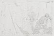
Wiltshire LXXIV.7 (includes: Berwick St John; Tollard Royal) - 25 Inch Map
1 : 2500 Topographic maps Ordnance Survey Ordnance Survey
Wiltshire LXXIV.8 (includes: Berwick St John; Ebbesbourne Wake; Sixpenny Handley) - 25 Inch Map
1 : 2500 Topographic maps Ordnance Survey Ordnance Survey
Wiltshire LXXIV.8 (includes: Berwick St John; Ebbesbourne Wake; Sixpenny Handley) - 25 Inch Map
1 : 2500 Topographic maps Ordnance Survey Ordnance Survey
Wiltshire LXXIV.8 (includes: Berwick St John; Ebbesbourne Wake; Sixpenny Handley) - 25 Inch Map
1 : 2500 Topographic maps Ordnance Survey Ordnance Survey
Wiltshire LXXIV.8 (includes: Berwick St John; Ebbesbourne Wake; Sixpenny Handley) - 25 Inch Map
1 : 2500 Topographic maps Ordnance Survey Ordnance Survey
Dorset IX.10 & 6 (includes: Berwick St John; Sixpenny Handley; Tollard Royal) - 25 Inch Map
1 : 2500 Topographic maps Ordnance Survey Ordnance Survey
Dorset IX.6 & 10 (includes: Berwick St John; Sixpenny Handley; Tollard Royal) - 25 Inch Map
1 : 2500 Topographic maps Ordnance Survey Ordnance Survey
Dorset IX.7 (includes: Berwick St John; Bower Chalke; Ebbesbourne Wake; Sixpenny Handley) - 25 Inch Map
1 : 2500 Topographic maps Ordnance Survey Ordnance Survey
Dorset IX.7 (includes: Berwick St John; Bower Chalke; Ebbesbourne Wake; Sixpenny Handley) - 25 Inch Map
1 : 2500 Topographic maps Ordnance Survey Ordnance Survey
Dorset IX.NE - OS Six-Inch Map
1 : 10560 Topographic maps Ordnance Survey Ordnance Survey
Dorset IX.NE - OS Six-Inch Map
1 : 10560 Topographic maps Ordnance Survey Ordnance Survey
Wiltshire LXXIV - OS Six-Inch Map
1 : 10560 Topographic maps Ordnance Survey Ordnance Survey
ST92 - OS 1:25,000 Provisional Series Map
1 : 25000 Topographic maps Ordnance Survey Ordnance Survey
ST91 - OS 1:25,000 Provisional Series Map
1 : 25000 Topographic maps Ordnance Survey Ordnance Survey
Dorset IX.10 & 6 (includes: Berwick St John; Sixpenny Handley; Tollard Royal) - 25 Inch Map
1 : 2500 Topographic maps Ordnance Survey Ordnance Survey
Dorset IX.6 & 10 (includes: Berwick St John; Sixpenny Handley; Tollard Royal) - 25 Inch Map
1 : 2500 Topographic maps Ordnance Survey Ordnance Survey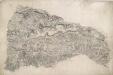
Berwick St. John
Small red crosses at Baverstoke, at the top centre, and Et Knoyle, at the top left,mark observation points used by the surveyor to plot topographical details and measure distances. The draughtsman has faithfully recorded the relative relief of the hills and indicated areas of woodland, using various shades of green to distinguish woods from grassland. The ancient circular earthworks of Chiselbury are marked by concentric rings on White Sheet Hill, in the centre of the drawing.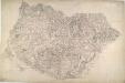
Cranborne
This drawing represents the relative relief of the landscape by light shading and interlining in pencil. Parallel pecked lines indicate paths across open land. Achling Ditch, a Roman road, runs diagonally across the drawing. To the left of the road is Blandford Race Ground and Telegraph. As well as being a racecourse until the end of the 19th century, Blandford was used as a military training ground by local volunteers from the 18th century onwards. In 1806, a Royal Navy Shutter Telegraph Station was built near the racecourse. The signal station, on the London to Plymouth route, was closed after the Napoleonic War. In the lower section of the map, concentric rings depict the iron-age hillfort of Badbury Rings.