Maps of Wiltshire
Wiltshire XLVII.NW - OS Six-Inch Map
1 : 10560 Topographic maps Ordnance Survey Ordnance Survey
Wiltshire XLVII.NW - OS Six-Inch Map
1 : 10560 Topographic maps Ordnance Survey Ordnance Survey
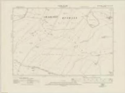
Wiltshire XLVII.1 (includes: Charlton; Marden; Rushall; Wilsford) - 25 Inch Map
1 : 2500 Topographic maps Ordnance Survey Ordnance Survey
Wiltshire XLVII.1 (includes: Charlton; Marden; Rushall; Wilsford) - 25 Inch Map
1 : 2500 Topographic maps Ordnance Survey Ordnance Survey
Wiltshire XLVII.1 (includes: Charlton; Marden; Rushall; Wilsford) - 25 Inch Map
1 : 2500 Topographic maps Ordnance Survey Ordnance Survey
Wiltshire XLVII.1 (includes: Charlton; Marden; Rushall; Wilsford) - 25 Inch Map
1 : 2500 Topographic maps Ordnance Survey Ordnance Survey
Wiltshire XLVII.1 (includes: Charlton; Marden; Rushall; Wilsford) - 25 Inch Map
1 : 2500 Topographic maps Ordnance Survey Ordnance Survey
Wiltshire XLVII.5 (includes: Charlton; Enford; Rushall; Upavon; Wilsford) - 25 Inch Map
1 : 2500 Topographic maps Ordnance Survey Ordnance Survey
Wiltshire XLVII.5 (includes: Charlton; Enford; Rushall; Upavon; Wilsford) - 25 Inch Map
1 : 2500 Topographic maps Ordnance Survey Ordnance Survey
Wiltshire XLVII.5 (includes: Charlton; Enford; Rushall; Upavon; Wilsford) - 25 Inch Map
1 : 2500 Topographic maps Ordnance Survey Ordnance Survey
Wiltshire XLVII.5 (includes: Charlton; Enford; Rushall; Upavon; Wilsford) - 25 Inch Map
1 : 2500 Topographic maps Ordnance Survey Ordnance Survey
Wiltshire XLVII.2 (includes: Charlton; Enford; Rushall; Upavon) - 25 Inch Map
1 : 2500 Topographic maps Ordnance Survey Ordnance Survey
Wiltshire XLVII.2 (includes: Charlton; Enford; Rushall; Upavon) - 25 Inch Map
1 : 2500 Topographic maps Ordnance Survey Ordnance Survey
Wiltshire XLVII.2 (includes: Charlton; Enford; Rushall; Upavon) - 25 Inch Map
1 : 2500 Topographic maps Ordnance Survey Ordnance Survey
Wiltshire XLVII.2 (includes: Charlton; Enford; Rushall; Upavon) - 25 Inch Map
1 : 2500 Topographic maps Ordnance Survey Ordnance Survey
Wiltshire XLVII.6 (includes: Enford; Rushall; Upavon) - 25 Inch Map
1 : 2500 Topographic maps Ordnance Survey Ordnance Survey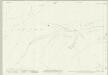
Wiltshire XLVII.6 (includes: Enford; Rushall; Upavon) - 25 Inch Map
1 : 2500 Topographic maps Ordnance Survey Ordnance Survey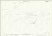
Wiltshire XLVII.6 (includes: Enford; Rushall; Upavon) - 25 Inch Map
1 : 2500 Topographic maps Ordnance Survey Ordnance Survey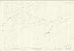
Wiltshire XLVII.6 (includes: Enford; Rushall; Upavon) - 25 Inch Map
1 : 2500 Topographic maps Ordnance Survey Ordnance Survey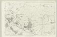
Wiltshire XLVII - OS Six-Inch Map
1 : 10560 Topographic maps Ordnance Survey Ordnance Survey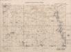
Salisbury Plain artillery ranges. Scale, 1 : 20,000
Geographical Section, General Staff, War Office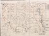
Salisbury Plain artillery ranges. Scale, 1 : 20,000

SU15 - OS 1:25,000 Provisional Series Map
1 : 25000 Topographic maps Ordnance Survey Ordnance Survey
SU05 - OS 1:25,000 Provisional Series Map
1 : 25000 Topographic maps Ordnance Survey Ordnance Survey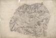
Wilcot
Several orientation points used to plot the survey appear at the edges of this drawing. The draughtsman has recorded the precise layout of the fir plantations at Everly, a chalk pit on Bushton Down, and the Roman road from Bath to Malborough, which is at the top of the drawing. The Kennet and Avon Canal also features. Opened in 1810 to better exploit the resources of the Somerset Coalfields, the canal is contemporary with the survey of this drawing. Extending from Shepherds Shore, a thick grey line is marked 'The Wansdyke'. This is a linear defensive earthwork dating from the 5th century. The area is rich is archaeological sites: Casterely Camp on Black Heath is a large hillfort. The paper is watermarked JAMES WHATMAN TURKEY MILL KENT 1807.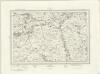
Devizes (Outline) - OS One-Inch Revised New Series
1 : 63360 Topographic maps Ordnance Survey Ordnance Survey
Devizes (Hills) - OS One-Inch Revised New Series
1 : 63360 Topographic maps Ordnance Survey Ordnance Survey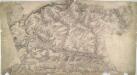
Warminster
1 : 31680 Although this drawing was surveyed six years before the obligatory inclusion of archaeological sites on drawings, several are featured. The most famous of these is Stonehenge, to the right of the drawing. Ancient camps, earthworks, castles and grave mounds ('tumuli') pepper the area, indicated by concentric shapes and a title in neat script. Their inclusion reveals the meticulous nature of the survey. To the right of the drawing, opposite Wishford, a trigonometrical station is indicated by a dot within a circle (annotated 'Col. Mudge's station' - Major-General William Mudge was Superintendent of the Ordnance Survey). This station denotes a point from which angular measurements were taken. In the right hand margin of the drawing a point titled "End of Base" marks the end of the Salisbury Plain baseline: an important measurement allowing for the triangulation of the area. Crocker, Edmund
Salisbury - OS One-Inch Map
1 : 63360 Topographic maps Ordnance Survey Ordnance Survey