Maps of Brentwood
Essex nLXI.SE - OS Six-Inch Map
1 : 10560 Topographic maps Ordnance Survey Ordnance Survey
Essex (1st Ed/Rev 1862-96) LIX.1 (includes: Kelvedon Hatch; Stanford Rivers) - 25 Inch Map
1 : 2500 Topographic maps Ordnance Survey Ordnance Survey
Essex (New Series 1913-) n LXI.16 (includes: Kelvedon Hatch; Navestock; Stanford Rivers) - 25 Inch Map
1 : 2500 Topographic maps Ordnance Survey Ordnance Survey
Essex (New Series 1913-) n LXI.15 (includes: Navestock; Stanford Rivers) - 25 Inch Map
1 : 2500 Topographic maps Ordnance Survey Ordnance Survey
Essex (New Series 1913-) n LXI.11 (includes: Stanford Rivers) - 25 Inch Map
1 : 2500 Topographic maps Ordnance Survey Ordnance Survey
Essex (New Series 1913-) n LXI.12 (includes: High Ongar; Kelvedon Hatch; Stanford Rivers) - 25 Inch Map
1 : 2500 Topographic maps Ordnance Survey Ordnance Survey
Essex (1st Ed/Rev 1862-96) LVIII.4 (includes: Stanford Rivers) - 25 Inch Map
1 : 2500 Topographic maps Ordnance Survey Ordnance Survey
Essex (1st Ed/Rev 1862-96) LIX.5 (includes: Kelvedon Hatch; Navestock; Stanford Rivers) - 25 Inch Map
1 : 2500 Topographic maps Ordnance Survey Ordnance Survey
Essex nLXI - OS Six-Inch Map
1 : 10560 Topographic maps Ordnance Survey Ordnance Survey
Essex LIX.NW - OS Six-Inch Map
1 : 10560 Topographic maps Ordnance Survey Ordnance Survey
Essex LVIII.NE - OS Six-Inch Map
1 : 10560 Topographic maps Ordnance Survey Ordnance Survey
Essex (1st Ed/Rev 1862-96) LVIII.8 (includes: Stanford Rivers) - 25 Inch Map
1 : 2500 Topographic maps Ordnance Survey Ordnance Survey
Essex (1st Ed/Rev 1862-96) LI.13 (includes: Chipping Ongar; Greenstead; High Ongar; Stanford Rivers) - 25 Inch Map
1 : 2500 Topographic maps Ordnance Survey Ordnance Survey
Essex (1st Ed/Rev 1862-96) L.16 (includes: Greenstead; Stanford Rivers) - 25 Inch Map
1 : 2500 Topographic maps Ordnance Survey Ordnance Survey
TL50 - OS 1:25,000 Provisional Series Map
1 : 25000 Topographic maps Ordnance Survey Ordnance Survey
Essex LIX - OS Six-Inch Map
1 : 10560 Topographic maps Ordnance Survey Ordnance Survey
Essex LVIII - OS Six-Inch Map
1 : 10560 Topographic maps Ordnance Survey Ordnance Survey
Essex LI.SW - OS Six-Inch Map
1 : 10560 Topographic maps Ordnance Survey Ordnance Survey
Essex L.SE - OS Six-Inch Map
1 : 10560 Topographic maps Ordnance Survey Ordnance Survey
Essex L.SE - OS Six-Inch Map
1 : 10560 Topographic maps Ordnance Survey Ordnance Survey
Essex (1st Ed/Rev 1862-96) LIX.2 (includes: Kelvedon Hatch; Stondon Massey) - 25 Inch Map
1 : 2500 Topographic maps Ordnance Survey Ordnance Survey
Essex (1st Ed/Rev 1862-96) LIX.6 (includes: Doddinghurst; Kelvedon Hatch; Navestock; Stondon Massey) - 25 Inch Map
1 : 2500 Topographic maps Ordnance Survey Ordnance Survey
Essex (1st Ed/Rev 1862-96) LI.14 (includes: High Ongar; Stondon Massey) - 25 Inch Map
1 : 2500 Topographic maps Ordnance Survey Ordnance Survey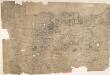
Enfield
Triangulation lines radiating from fixed points are clearly visible on this map. A pecked red line running adjacent to Lee River marks the boundary separating Essex from Hertforshire and Middlesex. Henhault Forest is shown by a stippled canopy of tree tops at the centre of the drawing. Perhaps the most interesting detail on this map is just south of the forest: a small drawing of a tree inside an enclosure marked 'Fairlop Oak'. This giant oak tree was something of a local landmark. In 1791, William Forsyth, gardener to George III, made unsuccessful attempts to halt the tree's decline. The year that this map was published, the tree was badly burnt by a fire started during a picnic. Its health steadily continued to wane until it was blown down in a gale in 1820. The inclusion of details such as the Fairlop Oak reveals the meticulous nature of the Survey, and the great attention paid to local detail. Budgen, Charles
Epping (Hills) - OS One-Inch Revised New Series
1 : 63360 Topographic maps Ordnance Survey Ordnance Survey
Epping (Outline) - OS One-Inch Revised New Series
1 : 63360 Topographic maps Ordnance Survey Ordnance Survey
London passenger transport map
Ordnance Survey
Ordnance Survey of England and Wales (Sheet 7), South Wales
Ordnance Survey, Great Britain
MAP of the COUNTRY 15 MILES ROUND London SHEWING BY A YELLOW CIRCLE OF 3 MILEs, THE LIMITS OF THE TWOPENNY POST DELIVERY
This map was commissioned by the House of Commons for the ninth report of the Post Office Management. The map's title features at top right, with an explanatory note and scale bar at bottom right. It shows the boundaries of the London Two-Penny Post, and the old and current boundaries of the Country Three-Penny Post, with mail routes highlighted in red. Post stages on the edges of the post area allowed mail to be exchanged between the London and the General Post on all main roads out of London. Wyld, James