Maps of Gloucestershire

Gloucestershire XLII.NW - OS Six-Inch Map
1 : 10560 Topographic maps Ordnance Survey Ordnance Survey
Gloucestershire XLII.NW - OS Six-Inch Map
1 : 10560 Topographic maps Ordnance Survey Ordnance Survey
Gloucestershire XLII.1 (includes: Cranham; Miserden; Painswick) - 25 Inch Map
1 : 2500 Topographic maps Ordnance Survey Ordnance Survey
Gloucestershire XLII.1 (includes: Cranham; Miserden; Painswick) - 25 Inch Map
1 : 2500 Topographic maps Ordnance Survey Ordnance Survey
Gloucestershire XLII.5 (includes: Bisley with Lypiatt; Miserden; Painswick) - 25 Inch Map
1 : 2500 Topographic maps Ordnance Survey Ordnance Survey
Gloucestershire XLII.5 (includes: Bisley with Lypiatt; Miserden; Painswick) - 25 Inch Map
1 : 2500 Topographic maps Ordnance Survey Ordnance Survey
Gloucestershire XLII.5 (includes: Bisley With Lypiatt; Miserden; Painswick) - 25 Inch Map
1 : 2500 Topographic maps Ordnance Survey Ordnance Survey
Gloucestershire XLII.6 (includes: Bisley with Lypiatt; Miserden; Painswick) - 25 Inch Map
1 : 2500 Topographic maps Ordnance Survey Ordnance Survey
Gloucestershire XLII.6 (includes: Bisley with Lypiatt; Miserden; Painswick) - 25 Inch Map
1 : 2500 Topographic maps Ordnance Survey Ordnance Survey
Gloucestershire XLII.6 (includes: Bisley with Lypiatt; Miserden; Painswick) - 25 Inch Map
1 : 2500 Topographic maps Ordnance Survey Ordnance Survey
Gloucestershire XLII.2 (includes: Brimpsfield; Cranham; Miserden; Painswick) - 25 Inch Map
1 : 2500 Topographic maps Ordnance Survey Ordnance Survey
Gloucestershire XLII.2 (includes: Brimpsfield; Cranham; Miserden; Painswick) - 25 Inch Map
1 : 2500 Topographic maps Ordnance Survey Ordnance Survey
Gloucestershire XLII.2 (includes: Brimpsfield; Cranham; Miserden; Painswick) - 25 Inch Map
1 : 2500 Topographic maps Ordnance Survey Ordnance Survey
Gloucestershire XLII - OS Six-Inch Map
1 : 10560 Topographic maps Ordnance Survey Ordnance Survey
Gloucester (Hills) - OS One-Inch Revised New Series
1 : 63360 Topographic maps Ordnance Survey Ordnance Survey
Gloucester (Outline) - OS One-Inch Revised New Series
1 : 63360 Topographic maps Ordnance Survey Ordnance Survey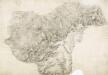
Cheltenham
1 : 31680 This finished plan is attributable to Robert Dawson (1771-1860). The attribution rests on his distinctive portrayal of relief. A dark wash is used for the lowland areas followed by bands of lighter colour, graduating to almost colourless at the top of hills - a technique that produces a strongly three-domensional effect. Black-ink numbers, clearly visible on the high spots, indicate the relative height of the hills: Hill 8 being higher than Hill 5. This method of notating contour, combined with brushwork interlining ('hachuring') drawn to indicate the steepness of relief, precedes the official introduction of contouring on Ordnance Survey maps in 1839-40. Rows of small neat trees depicting orchards proliferate around the Vale of Gloucester, at the top left of this map. Dawson, Robert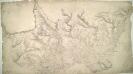
Cirencester(002OSD000000020U00118000)
1 : 31680 This drawing covers the counties of Gloucestershire, Oxfordshire and Wiltshire, with their boundaries indicated by pecked lines. The Roman road to Bath is tinted yellow to highlight it as a major communication route. A dotted line leading from Sapperton indicates the Sapperton Tunnel, which was opened in 1789. Linked to the Thames and Severn Canal, it was, at that time, the longest tunnel in England. The Sapperton Tunnel enabled boats carry coal cheaply to Cirencester from mines in the north and west. Several trigonometrical points are marked by dots within circles. These were points from which the surveyor took angular measurements to determine the relative locations of prominent features of the landscape. Metcalf, Edward B.
Swindon - OS One-Inch Map
1 : 63360 Topographic maps Ordnance Survey Ordnance Survey
Bristol and Stroud - OS One-Inch Map
1 : 63360 Topographic maps Ordnance Survey Ordnance Survey
Cheltenham and Evesham - OS One-Inch Map
1 : 63360 Topographic maps Ordnance Survey Ordnance Survey
Gloucester and Malvern - OS One-Inch Map
1 : 63360 Topographic maps Ordnance Survey Ordnance Survey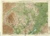
Hereford, Sheet 23 - Bartholomew's "Half Inch to the Mile Maps" of England & Wales
1 : 126720 Topographic maps Bartholomew, John George John Bartholomew & Co
HEREFORDIA | COMITATVS. | HEREFORD-SHIRE.
[Amsterdam : Joan Blaeu]

Herefordia Comitatus. Hereford-Shire. [Karte], in: Theatrum orbis terrarum, sive, Atlas novus, Bd. 4, S. 393.
1 Karte aus Atlas Blaeu, Joan Blaeu, Willem Janszoon
Herefordia Comitatus. Hereford-Shire. [Karte], in: Theatrum orbis terrarum, sive, Atlas novus, Bd. 4, S. 393.
1 Karte aus Atlas Blaeu, Joan Blaeu, Willem Janszoon
Herefordia Comitatus. Hereford-Shire. [Karte], in: Le théâtre du monde, ou, Nouvel atlas contenant les chartes et descriptions de tous les païs de la terre, Bd. 4, S. 339.
1 Karte aus Atlas Blaeu, Willem Janszoon und Blaeu, Joan Blaeu, Willem Janszoon
HEREFORDIAE COMITATUS f.95
This is a map of Herefordshire by Christopher Saxton dating from 1577. It forms part of an atlas that belonged to William Cecil Lord Burghley, Elizabeth I’s Secretary of State. Burghley used this atlas to illustrate domestic matters. This map is actually a proof copy of one which forms part of Christopher Saxton’s Atlas of England and Wales. This atlas was first published as a whole in 1579. It consists of 35 coloured maps depicting the counties of England and Wales. The atlas is of great significance to British cartography as it set a standard of cartographic representation in Britain and the maps remained the basis for English county mapping, with few exceptions, until after 1750. During the reign of Elizabeth I, map use became more common, with many government matters referring to increasingly accurate maps with consistent scales and symbols, made possible by advances in surveying techniques. Illustrating the increasing use of maps in government matters, Lord Burghley, who had been determined to have England and Wales mapped in detail from the 1550s, selected the cartographer Christopher Saxton to produce a detailed and consistent survey of the country. The financier of the project was Thomas Seckford, Master of Requests at the Court of Elizabeth I, whose arms appear, along with the royal crest, on each map. Burghley has annotated this map, underlining the information printed at Kinnaston chap Wch Was dreven downe by the removing of the ground. The map was engraved by Remigius Hogenbergius, one of a team of seven English and Flemish engravers employed to produce the copper plates for the atlas. Saxton, Christopher Hogenbergius, Remigius