Maps of Milton Keynes
Buckinghamshire XV.SW - OS Six-Inch Map
1 : 10560 Topographic maps Ordnance Survey Ordnance Survey
Buckinghamshire XV.SW - OS Six-Inch Map
1 : 10560 Topographic maps Ordnance Survey Ordnance Survey
Buckinghamshire XV.SW - OS Six-Inch Map
1 : 10560 Topographic maps Ordnance Survey Ordnance Survey
Buckinghamshire XV.SW - OS Six-Inch Map
1 : 10560 Topographic maps Ordnance Survey Ordnance Survey
Buckinghamshire XV.14 (includes: Bletchley; Great Brickhill) - 25 Inch Map
1 : 2500 Topographic maps Ordnance Survey Ordnance Survey
Buckinghamshire XV.14 (includes: Bletchley; Great Brickhill) - 25 Inch Map
1 : 2500 Topographic maps Ordnance Survey Ordnance Survey
Buckinghamshire XV.14 (includes: Bletchley; Great Brickhill) - 25 Inch Map
1 : 2500 Topographic maps Ordnance Survey Ordnance Survey
Buckinghamshire XV.10 (includes: Bletchley) - 25 Inch Map
1 : 2500 Topographic maps Ordnance Survey Ordnance Survey
Buckinghamshire XV.10 (includes: Bletchley) - 25 Inch Map
1 : 2500 Topographic maps Ordnance Survey Ordnance Survey
Buckinghamshire XV.10 (includes: Bletchley) - 25 Inch Map
1 : 2500 Topographic maps Ordnance Survey Ordnance Survey
Buckinghamshire XV.13 (includes: Bletchley; Newton Longville) - 25 Inch Map
1 : 2500 Topographic maps Ordnance Survey Ordnance Survey
Buckinghamshire XV.13 (includes: Bletchley; Newton Longville) - 25 Inch Map
1 : 2500 Topographic maps Ordnance Survey Ordnance Survey
Buckinghamshire XV.13 (includes: Bletchley; Newton Longville) - 25 Inch Map
1 : 2500 Topographic maps Ordnance Survey Ordnance Survey
Buckinghamshire XV.13 (includes: Bletchley; Newton Longville) - 25 Inch Map
1 : 2500 Topographic maps Ordnance Survey Ordnance Survey
Buckinghamshire XV.9 (includes: Bletchley; Shenley Brook End) - 25 Inch Map
1 : 2500 Topographic maps Ordnance Survey Ordnance Survey
Buckinghamshire XV.9 (includes: Bletchley; Shenley Brook End) - 25 Inch Map
1 : 2500 Topographic maps Ordnance Survey Ordnance Survey
Buckinghamshire XV.9 (includes: Bletchley; Shenley Brook End) - 25 Inch Map
1 : 2500 Topographic maps Ordnance Survey Ordnance Survey
Bedfordshire XXIV.5 (includes: Bletchley; Bow Brickhill; Great Brickhill; Little Brickhill) - 25 Inch Map
1 : 2500 Topographic maps Ordnance Survey Ordnance Survey
Buckinghamshire XV - OS Six-Inch Map
1 : 10560 Topographic maps Ordnance Survey Ordnance Survey
SP83 - OS 1:25,000 Provisional Series Map
1 : 25000 Topographic maps Ordnance Survey Ordnance Survey
Bedfordshire XXIV.NW - OS Six-Inch Map
1 : 10560 Topographic maps Ordnance Survey Ordnance Survey
Bedfordshire XXIV.NW - OS Six-Inch Map
1 : 10560 Topographic maps Ordnance Survey Ordnance Survey
Bedfordshire XXIV.NW - OS Six-Inch Map
1 : 10560 Topographic maps Ordnance Survey Ordnance Survey
Leighton Buzzard (Hills) - OS One-Inch Revised New Series
1 : 63360 Topographic maps Ordnance Survey Ordnance Survey
Leighton Buzzard (Outline) - OS One-Inch Revised New Series
1 : 63360 Topographic maps Ordnance Survey Ordnance Survey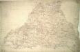
Stony Stratford
1 : 31680 The county boundary of Buckinghamshire and Northamptonshire is depicted to the right of the sheet as a red pecked line. It can be seen following sections of the River Ouse. Two ancient forests are also shown: the Royal Forest of Whittlewood, a medieval hunting forest, is at middle left; and Salcey Forest, the heart of the ancient woodland belt of the East Midlands, is shown at top left. A section of the Watling Street is indicated from bottom left to top right. This ancient Roman road ran from London to Wroxeter in Wales, via St. Albans and Leicester (where it intersected the Fosse Way, the Roman road from Exeter to Lincoln). Boyce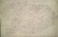
Winslow
1 : 31680 Enclosed farmland characterises the landscape of this part of Buckinghamshire. To the right of the manuscript, a section of the Grand Junction Canal is depicted running from Leighton Buzzard to Fenny Strafford along the River Fosse Valley. Two Roman roads are depicted on the plan: the Watling Street from London to Wroxeter in Wales via St. Albans and Leicester, at top right, and the Akeman Street Way, at lower left. Boyce
London passenger transport map
Ordnance Survey
Woburn
1 : 31680 This county boundary of Bedfordshire and Buckinghamshire is depicted as a black dotted line at bottom left. Down the right of the sheet, many triangulation points are marked in red ink. Toll roads are highlighted in yellow, with turnpikes indicated along their routes. A section of the Watling Street, between Dunstable and Little Brickhill, is indicated near the bottom of the sheet. This Roman road ran from London to Wroxeter in Wales, via St. Albans. Symbols distinguish different types land use, while shading is used to indicate relief. Hyett, William