Maps of North Dorset
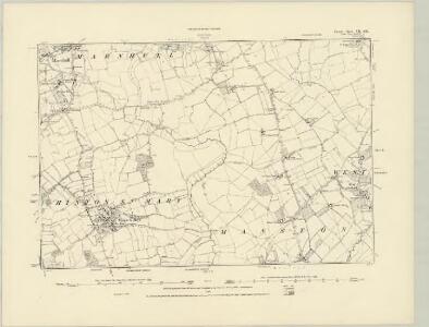
Dorset VII.SW - OS Six-Inch Map
1 : 10560 Topographic maps Ordnance Survey Ordnance Survey
Dorset VII.SW - OS Six-Inch Map
1 : 10560 Topographic maps Ordnance Survey Ordnance Survey
Dorset VII.SW - OS Six-Inch Map
1 : 10560 Topographic maps Ordnance Survey Ordnance Survey
Dorset VII.10 (includes: Marnhull; Stalbridge; Sturminster Newton) - 25 Inch Map
1 : 2500 Topographic maps Ordnance Survey Ordnance Survey
Dorset VII.9 (includes: Stalbridge) - 25 Inch Map
1 : 2500 Topographic maps Ordnance Survey Ordnance Survey
Dorset VII.13 (includes: Stalbridge) - 25 Inch Map
1 : 2500 Topographic maps Ordnance Survey Ordnance Survey
Dorset VII.14 (includes: Hinton St Mary; Marnhull; Stalbridge; Sturminster Newton) - 25 Inch Map
1 : 2500 Topographic maps Ordnance Survey Ordnance Survey
Dorset VII.14 (includes: Hinton St Mary; Marnhull; Stalbridge; Sturminster Newton) - 25 Inch Map
1 : 2500 Topographic maps Ordnance Survey Ordnance Survey
ST71 - OS 1:25,000 Provisional Series Map
1 : 25000 Topographic maps Ordnance Survey Ordnance Survey
Shaftesbury (Hills) - OS One-Inch Revised New Series
1 : 63360 Topographic maps Ordnance Survey Ordnance Survey
Shaftesbury (Outline) - OS One-Inch Revised New Series
1 : 63360 Topographic maps Ordnance Survey Ordnance Survey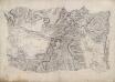
Wincanton
This drawing is rich in archaeological sites, the most notable being Cadbury Castle, which, according to legend, is the Camelot of Arthurian myth. It is marked by several concentric rings inside a band of dense shading, smudged at the top, indicating a steep mound. It was not until 1839-40 that contour lines were introduced into Ordnance Survey drawings, and so the two large blank areas on the map represent low fluvial tracts. Red pecked lines denote the boundaries between Dorset, Somerset and Wiltshire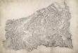
Sherborne
A red pecked line describes the border between the counties of Dorset and Somerset. Telegraph poles are marked by red dots along the lower edge of the drawing, indicating that the area covered is only a few miles from the coast. To the right of the landmass, red circles and crosses mark observation points outside the drawing's boundaries. Archaeological sites are also marked: an iron-age hillfort at Rawlsbury in the lower right is depicted by concentric rings. To the right of this is Dungeon Hill, a hillfort surrounded by a single rampart and a ditch, indicated by shading.
Shaftesbury
1 : 31680 This drawing covers the counties of Dorset, Somerset and Wiltshire, with their boundaries marked by pecked red lines. Relief is indicated by shading and interlining, giving an impression of the undulations of the land. Although the recording of archaeological sites did not become obligatory until 1816, the remains of Whitesheet Castle appear at the top centre of the drawing. Pencil lines can be seen at the edge of the drawing near Pimperne. This was an observation or measuring point for the survey.
Dorset Shire, 2
2 Blätter : 109 x 53 cm s.n.
Dorchester - OS One-Inch Map
1 : 63360 Topographic maps Ordnance Survey Ordnance Survey
Frome - OS One-Inch Map
1 : 63360 Topographic maps Ordnance Survey Ordnance Survey
Cary's Improved Map of England and Wales
Cary, George, & Cary, John London : G. & J. Cary
Comitatus Dorcestria, sive Dorsettia ; vulgo anglice Dorset Shire
1 : 145000
An improved map of Wilt Shire
1 Karte : Kupferdruck ; 52 x 68 cm Bowen; Tinney sold by I. Tinney at the Golden Lion in Fleet street
Wiltonia sive comitatvs Wiltoniensis; anglis Wil Shire
1 Karte : Kupferdruck ; 40 x 48 cm Blaeu Joan Blaeu
Comitatus Dorcestria vulgo anglice Dorset Shire
1 : 170000 Amstelodami : apud Joannem Janssonium
Wiltonia sive Comitatus Wiltoniensis anglis Wil Shire
1 : 210000 Amstelodami : apud Joannem Janssonium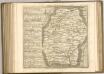

An accurate map of Dorset Shire divided into hundreds
1 : 222000
Map of Dorsetshire
This map comes from the Abbott's Illustrated Counties series of county guides: Dorsetshire, its history, antiquities, places of interest, etc a complete, concise and exhaustive story of Dorset from the earliest times to the present day' The Guide Printing & Publishing Co.
An improved map of the county of Somerset
1 Karte : Kupferdruck ; 51 x 68 cm Bowen; Hinton sold by I. Hinton at the Kings Arms in St. Pauls Church Yard
Somersettensis comitatvs
1 Karte : Kupferdruck ; 36 x 48 cm Valck; Schenk apud G. Valk et P. Schenk
Somersettensis comitatvs
1 Karte : Kupferdruck ; 37 x 48 cm Blaeu Joan Blaeu