Maps of Plymouth
Devonshire CXXX.NW - OS Six-Inch Map
1 : 10560 Topographic maps Ordnance Survey Ordnance Survey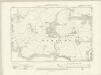
Devonshire CXXX.NW - OS Six-Inch Map
1 : 10560 Topographic maps Ordnance Survey Ordnance Survey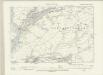
Devonshire CXXX.NW - OS Six-Inch Map
1 : 10560 Topographic maps Ordnance Survey Ordnance Survey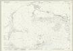
Devon CXXX.2 (includes: Brixton; Plymstock; Wembury) - 25 Inch Map
1 : 2500 Topographic maps Ordnance Survey Ordnance Survey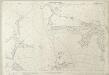
Devon CXXX.2 (includes: Brixton; Plymstock; Wembury) - 25 Inch Map
1 : 2500 Topographic maps Ordnance Survey Ordnance Survey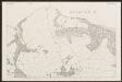
Devon CXXX.2 (includes: Brixton; Plymstock; Wembury) - 25 Inch Map
1 : 2500 Topographic maps Ordnance Survey Ordnance Survey
Devon CXXX.2 (includes: Brixton; Plymstock; Wembury) - 25 Inch Map
1 : 2500 Topographic maps Ordnance Survey Ordnance Survey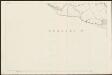
Devon CXXX.2 (includes: Brixton; Plymstock; Wembury) - 25 Inch Map
1 : 2500 Topographic maps Ordnance Survey Ordnance Survey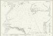
Devon CXXX.6 (includes: Newton and Noss; Wembury) - 25 Inch Map
1 : 2500 Topographic maps Ordnance Survey Ordnance Survey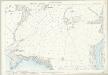
Devon CXXX.6 (includes: Newton and Noss; Wembury) - 25 Inch Map
1 : 2500 Topographic maps Ordnance Survey Ordnance Survey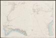
Devon CXXX.6 (includes: Newton and Noss; Wembury) - 25 Inch Map
1 : 2500 Topographic maps Ordnance Survey Ordnance Survey
Devon CXXX.11 (inset CXXX.6 & CXXX.10) (includes: Newton and Noss; Wembury) - 25 Inch Map
1 : 2500 Topographic maps Ordnance Survey Ordnance Survey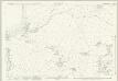
Devon CXXX.1 (includes: Plymstock; Wembury) - 25 Inch Map
1 : 2500 Topographic maps Ordnance Survey Ordnance Survey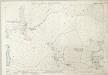
Devon CXXX.1 (includes: Plymstock; Wembury) - 25 Inch Map
1 : 2500 Topographic maps Ordnance Survey Ordnance Survey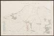
Devon CXXX.1 (includes: Plymstock; Wembury) - 25 Inch Map
1 : 2500 Topographic maps Ordnance Survey Ordnance Survey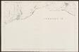
Devon CXXX.1 (includes: Plymstock; Wembury) - 25 Inch Map
1 : 2500 Topographic maps Ordnance Survey Ordnance Survey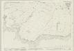
Devon CXXX.5 (includes: Wembury) - 25 Inch Map
1 : 2500 Topographic maps Ordnance Survey Ordnance Survey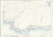
Devon CXXX.5 (includes: Wembury) - 25 Inch Map
1 : 2500 Topographic maps Ordnance Survey Ordnance Survey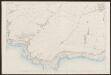
Devon CXXX.5 (includes: Wembury) - 25 Inch Map
1 : 2500 Topographic maps Ordnance Survey Ordnance Survey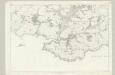
Devonshire CXXX - OS Six-Inch Map
1 : 10560 Topographic maps Ordnance Survey Ordnance Survey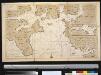
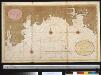
Nieuwe afteekeningh van de haven van Plijmouth geleegen int Canaal aen de kust van Engeland
England Gerard van Keulen
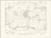
To the Right Honorable the Master, Wardens & Elder Brethren of the Trinity House, this Chart of Plymouth Sound is ... dedicated
1 : 26000 Heather, W. (William) Heather, W. (William)
A coloured scheme for fortifying the island of St Nicholas, or Drake's Island, in Plymouth Sound
Plan of Plymouth harbour with particular attention to St Nicholas Island thought to have been drawn by a French or Dutch artist. It is said that when he was a child, Sir Francis Drake was sent here by his parents for protection at a time of civil disturbance. In the 18th century the island was renamed Drake’s Island in his memory but until the mid 19th century it was still referred to as St Nicholas Island. The island was first fortified in the 17th century and was important because it was situated in the centre of Plymouth Sound and protected the approaches to the harbours and the estuaries of the rivers Tamar and Plym.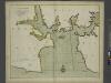
A new and correct large draught PLYMOUTH SOUND catt-water and ham-owse
from The sea-atlas : containing an hydrographical description of most of the sea-coasts of the known parts of the world.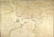
General Plan of the Ports of Homouse and Plymouth
Plan of the Ports of Hamoaze and Plymouth in Devon. This is the point where the rivers Tamar, Tavy and Lynher enter Plymouth Sound. Proposals for a dockyard at Hamoaze were first proposed by Sir Francis Drake in the late 16th century. It was felt that the broad estuary here afforded excellent natural protection however it was not until 1690 that work began here. William III appointed Edmund Dummer, surveyor to the Royal Navy, to build the dock and it became known as Plymouth Dock. By the 19th century Plymouth Dock was actually bigger than Plymouth itself and in 1824 it became independent, the town and the dockyard becoming known as Davenport. This is now the largest naval base in Western Europe.
Cornwall LV - OS Six-Inch Map
1 : 10560 Topographic maps Ordnance Survey Ordnance Survey
Ivybridge (Hills) - OS One-Inch Revised New Series
1 : 63360 Topographic maps Ordnance Survey Ordnance Survey
Ivybridge (Outline) - OS One-Inch Revised New Series
1 : 63360 Topographic maps Ordnance Survey Ordnance Survey
Plymouth - OS One-Inch Map
1 : 63360 Topographic maps Ordnance Survey Ordnance Survey