Maps of Plymouth
Devonshire CXVIII.SW - OS Six-Inch Map
1 : 10560 Topographic maps Ordnance Survey Ordnance Survey
Devonshire CXVIII.SW - OS Six-Inch Map
1 : 10560 Topographic maps Ordnance Survey Ordnance Survey
Devon CXVIII.10 (includes: Bickleigh; Plymouth; Shaugh Prior; Sparkwell) - 25 Inch Map
1 : 2500 Topographic maps Ordnance Survey Ordnance Survey
Devon CXVIII.10 (includes: Bickleigh; Plymouth; Shaugh Prior; Sparkwell) - 25 Inch Map
1 : 2500 Topographic maps Ordnance Survey Ordnance Survey
Devon CXVIII.6 (inset CXVIII.9 & CXVIII.10) (includes: Bickleigh; Plymouth; Shaugh Prior; Sparkwell) - 25 Inch Map
1 : 2500 Topographic maps Ordnance Survey Ordnance Survey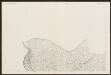
Devon CXVIII.10 (includes: Bickleigh; Plymouth; Shaugh Prior; Sparkwell) - 25 Inch Map
1 : 2500 Topographic maps Ordnance Survey Ordnance Survey
Devon CXVIII.10 (includes: Bickleigh; Plymouth; Shaugh Prior; Sparkwell) - 25 Inch Map
1 : 2500 Topographic maps Ordnance Survey Ordnance Survey
Devon CXVIII.14 (includes: Plymouth; Sparkwell) - 25 Inch Map
1 : 2500 Topographic maps Ordnance Survey Ordnance Survey
Devon CXVIII.14 (includes: Plymouth; Sparkwell) - 25 Inch Map
1 : 2500 Topographic maps Ordnance Survey Ordnance Survey
Devon CXVIII.14 (includes: Plymouth; Sparkwell) - 25 Inch Map
1 : 2500 Topographic maps Ordnance Survey Ordnance Survey
Devon CXVIII.14 (inset CXVIII.13) (includes: Plymouth; Sparkwell) - 25 Inch Map
1 : 2500 Topographic maps Ordnance Survey Ordnance Survey
Devon CXVIII.14 (includes: Plymouth; Sparkwell) - 25 Inch Map
1 : 2500 Topographic maps Ordnance Survey Ordnance Survey
Devon CXVIII.9 (includes: Bickleigh; Plymouth) - 25 Inch Map
1 : 2500 Topographic maps Ordnance Survey Ordnance Survey
Devon CXVIII.6 (inset CXVIII.9 & CXVIII.10) (includes: Bickleigh; Plymouth) - 25 Inch Map
1 : 2500 Topographic maps Ordnance Survey Ordnance Survey
Devon CXVIII.9 (includes: Bickleigh; Plymouth) - 25 Inch Map
1 : 2500 Topographic maps Ordnance Survey Ordnance Survey
Devon CXVIII.9 (includes: Bickleigh; Plymouth) - 25 Inch Map
1 : 2500 Topographic maps Ordnance Survey Ordnance Survey
Devon CXVIII.9 (includes: Bickleigh; Plymouth) - 25 Inch Map
1 : 2500 Topographic maps Ordnance Survey Ordnance Survey
Devon CXVIII.13 (includes: Plymouth; Sparkwell) - 25 Inch Map
1 : 2500 Topographic maps Ordnance Survey Ordnance Survey
Devon CXVIII.13 (includes: Plymouth; Sparkwell) - 25 Inch Map
1 : 2500 Topographic maps Ordnance Survey Ordnance Survey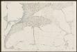
Devon CXVIII.14 (inset CXVIII.13) (includes: Plymouth; Sparkwell) - 25 Inch Map
1 : 2500 Topographic maps Ordnance Survey Ordnance Survey
Devon CXVIII.13 (includes: Plymouth; Sparkwell) - 25 Inch Map
1 : 2500 Topographic maps Ordnance Survey Ordnance Survey
Devon CXVIII.13 (includes: Plymouth; Sparkwell) - 25 Inch Map
1 : 2500 Topographic maps Ordnance Survey Ordnance Survey
Devonshire CXVIII - OS Six-Inch Map
1 : 10560 Topographic maps Ordnance Survey Ordnance Survey
Cornwall XLVI - OS Six-Inch Map
1 : 10560 Topographic maps Ordnance Survey Ordnance Survey
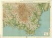
A coloured chart of Plymouth Harbour, and of the country up to Tavistock; drawn possibly by Robert Spry
This is a map of Plymouth and environs and is a 16th century copy of an original map dating from 1591 by Robert Spry. Spry is recorded as a painter in municipal records between 1569-70 and 1591-2. The map is drawn in a somewhat archaic pictorial style with topographical details drawn in perspective. Great detail has been observed in the depiction of churches and country houses and three beacons, the means of alerting the surrounding area, are recorded. The anchorages of the Sound are marked by drawings of ships. The map shows the conduit or leat that was constructed by Sir Francis Drake in 1590-1 in order to provide a water-supply for the town from Dartmoor. In connection with his leat, Drake had been granted a lease of the six town mills in 1583. The leat was designed for the watering of ships and to power the mills and played a central role in Drake’s hopeful project to make Plymouth a powerful naval station. Although popular local tradition suggested that Drake had employed magic in order to effect the construction of the leat which passed through "mighti rockes which was thought unpossible to carrie water through", it was in fact the work of the Plymouth engineers Robert Lampen and his brother. Figures along the course of the leat, from the River Meavy to Plymouth record miles. A section that is likely to have contained an explanatory table has been removed, resulting in the maps irregular shape. Spry, Robert
Ivybridge (Hills) - OS One-Inch Revised New Series
1 : 63360 Topographic maps Ordnance Survey Ordnance Survey
Ivybridge (Outline) - OS One-Inch Revised New Series
1 : 63360 Topographic maps Ordnance Survey Ordnance Survey
Plymouth - OS One-Inch Map
1 : 63360 Topographic maps Ordnance Survey Ordnance Survey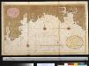
Een gedeelte van het Kanaal vant eijland Bun tot de R. van Vaalmouth
England Gerard van Keulen