Maps of Shipton Bellinger
Hampshire & Isle of Wight XXII.NE - OS Six-Inch Map
1 : 10560 Topographic maps Ordnance Survey Ordnance Survey
Hampshire & Isle of Wight XXII.NE - OS Six-Inch Map
1 : 10560 Topographic maps Ordnance Survey Ordnance Survey
Hampshire & Isle of Wight XXII.NE - OS Six-Inch Map
1 : 10560 Topographic maps Ordnance Survey Ordnance Survey
Hampshire & Isle of Wight XXII.NE - OS Six-Inch Map
1 : 10560 Topographic maps Ordnance Survey Ordnance Survey
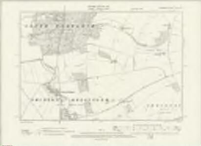
Hampshire & Isle of Wight XXII.NE - OS Six-Inch Map
1 : 10560 Topographic maps Ordnance Survey Ordnance Survey
Hampshire and Isle of Wight XXII.3 (includes: Shipton Bellinger; South Tedworth) - 25 Inch Map
1 : 2500 Topographic maps Ordnance Survey Ordnance Survey
Hampshire and Isle of Wight XXII.3 (includes: Shipton Bellinger; South Tedworth) - 25 Inch Map
1 : 2500 Topographic maps Ordnance Survey Ordnance Survey
Hampshire and Isle of Wight XXII.3 (includes: Shipton Bellinger; South Tedworth) - 25 Inch Map
1 : 2500 Topographic maps Ordnance Survey Ordnance Survey
Hampshire and Isle of Wight XXII.7 (includes: Shipton Bellinger) - 25 Inch Map
1 : 2500 Topographic maps Ordnance Survey Ordnance Survey
Hampshire and Isle of Wight XXII.7 (includes: Shipton Bellinger) - 25 Inch Map
1 : 2500 Topographic maps Ordnance Survey Ordnance Survey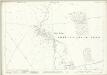
Hampshire and Isle of Wight XXII.7 (includes: Shipton Bellinger) - 25 Inch Map
1 : 2500 Topographic maps Ordnance Survey Ordnance Survey
Hampshire and Isle of Wight XXII.7 (includes: Shipton Bellinger) - 25 Inch Map
1 : 2500 Topographic maps Ordnance Survey Ordnance Survey
Hampshire and Isle of Wight XXII.4 (includes: Kimpton; Shipton Bellinger; South Tedworth) - 25 Inch Map
1 : 2500 Topographic maps Ordnance Survey Ordnance Survey
Hampshire and Isle of Wight XXII.4 (includes: Kimpton; Shipton Bellinger; South Tedworth) - 25 Inch Map
1 : 2500 Topographic maps Ordnance Survey Ordnance Survey
Hampshire and Isle of Wight XXII.4 (includes: Kimpton; Shipton Bellinger; South Tedworth) - 25 Inch Map
1 : 2500 Topographic maps Ordnance Survey Ordnance Survey
Hampshire and Isle of Wight XXII.8 (includes: Amport; Kimpton; Shipton Bellinger; Thruxton) - 25 Inch Map
1 : 2500 Topographic maps Ordnance Survey Ordnance Survey
Hampshire and Isle of Wight XXII.8 (includes: Amport; Kimpton; Shipton Bellinger; Thruxton) - 25 Inch Map
1 : 2500 Topographic maps Ordnance Survey Ordnance Survey
Hampshire and Isle of Wight XXII.8 (includes: Amport; Kimpton; Shipton Bellinger; Thruxton) - 25 Inch Map
1 : 2500 Topographic maps Ordnance Survey Ordnance Survey
Hampshire and Isle of Wight XXII.8 (includes: Amport; Kimpton; Shipton Bellinger; Thruxton) - 25 Inch Map
1 : 2500 Topographic maps Ordnance Survey Ordnance Survey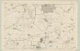
Hampshire & Isle of Wight XXII - OS Six-Inch Map
1 : 10560 Topographic maps Ordnance Survey Ordnance Survey
SU24 - OS 1:25,000 Provisional Series Map
1 : 25000 Topographic maps Ordnance Survey Ordnance Survey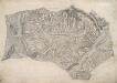
Andover
This drawing delineates the county border of Hampshire and Wiltshire. The boundary is marked as a red pecked line and follows the path of main roads and field boundaries. At Fullerton, the River Test branches into its tributaries. The draughtsman names each river and canal and depicts their various intersections. Main communication routes are tinted yellow, with the road near Doles Wood at the top of the plan marked "TG", meaning toll gate. Attention paid to communication routes is evidence of the military focus of the survey. Several archaeological sites are marked in this area, with the neighbouring hillforts of Sidbury and Quarley indicated by concentric rings towards the top left of the map. Varying shades of green are used to distinguish forests and meadows.
Map of Hampshire, including the Isle of Wight, 1
1 Blatt : 55 x 68 cm s.n.
Map of Hampshire, including the Isle of Wight, 3
1 Blatt : 53 x 68 cm s.n.
Salisbury - OS One-Inch Map
1 : 63360 Topographic maps Ordnance Survey Ordnance Survey
Cary's Improved Map of England and Wales
Cary, George, & Cary, John London : G. & J. Cary
An improved map of Wilt Shire
1 Karte : Kupferdruck ; 52 x 68 cm Bowen; Tinney sold by I. Tinney at the Golden Lion in Fleet street
Wiltonia sive comitatvs Wiltoniensis; anglis Wil Shire
1 Karte : Kupferdruck ; 40 x 48 cm Blaeu Joan Blaeu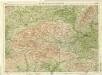
Berkshire, Sheet 29 - Bartholomew's "Half Inch to the Mile Maps" of England & Wales
1 : 126720 Topographic maps Bartholomew, John George John Bartholomew & Co