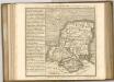
Maps of Litchfield and Woodcott
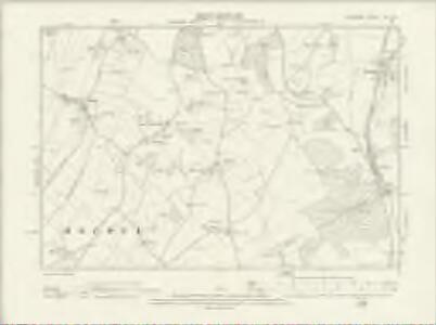
Hampshire & Isle of Wight XVI.NE - OS Six-Inch Map
1 : 10560 Topographic maps Ordnance Survey Ordnance Survey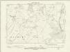
Hampshire & Isle of Wight XVI.NE - OS Six-Inch Map
1 : 10560 Topographic maps Ordnance Survey Ordnance Survey
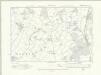
Hampshire and Isle of Wight XVI.3 (includes: Ashmansworth; Litchfield and Woodcott; St Mary Bourne) - 25 Inch Map
1 : 2500 Topographic maps Ordnance Survey Ordnance Survey
Hampshire and Isle of Wight XVI.3 (includes: Ashmansworth; Litchfield and Woodcott; St Mary Bourne) - 25 Inch Map
1 : 2500 Topographic maps Ordnance Survey Ordnance Survey
Hampshire and Isle of Wight XVI.7 (includes: St Mary Bourne) - 25 Inch Map
1 : 2500 Topographic maps Ordnance Survey Ordnance Survey
Hampshire and Isle of Wight XVI.7 (includes: St Mary Bourne) - 25 Inch Map
1 : 2500 Topographic maps Ordnance Survey Ordnance Survey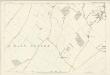
Hampshire and Isle of Wight XVI.7 (includes: St Mary Bourne) - 25 Inch Map
1 : 2500 Topographic maps Ordnance Survey Ordnance Survey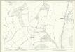
Hampshire and Isle of Wight XVI.4 (includes: Litchfield and Woodcott; St Mary Bourne; Whitchurch) - 25 Inch Map
1 : 2500 Topographic maps Ordnance Survey Ordnance Survey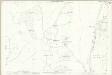
Hampshire and Isle of Wight XVI.4 (includes: Litchfield and Woodcott; St Mary Bourne; Whitchurch) - 25 Inch Map
1 : 2500 Topographic maps Ordnance Survey Ordnance Survey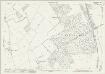
Hampshire and Isle of Wight XVI.8 (includes: Litchfield and Woodcott; St Mary Bourne; Whitchurch) - 25 Inch Map
1 : 2500 Topographic maps Ordnance Survey Ordnance Survey
Hampshire and Isle of Wight XVI.8 (includes: Litchfield and Woodcott; St Mary Bourne; Whitchurch) - 25 Inch Map
1 : 2500 Topographic maps Ordnance Survey Ordnance Survey
SU45 - OS 1:25,000 Provisional Series Map
1 : 25000 Topographic maps Ordnance Survey Ordnance Survey
Andover (Hills) - OS One-Inch Revised New Series
1 : 63360 Topographic maps Ordnance Survey Ordnance Survey
Andover (Outline) - OS One-Inch Revised New Series
1 : 63360 Topographic maps Ordnance Survey Ordnance Survey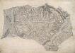
Andover
This drawing delineates the county border of Hampshire and Wiltshire. The boundary is marked as a red pecked line and follows the path of main roads and field boundaries. At Fullerton, the River Test branches into its tributaries. The draughtsman names each river and canal and depicts their various intersections. Main communication routes are tinted yellow, with the road near Doles Wood at the top of the plan marked "TG", meaning toll gate. Attention paid to communication routes is evidence of the military focus of the survey. Several archaeological sites are marked in this area, with the neighbouring hillforts of Sidbury and Quarley indicated by concentric rings towards the top left of the map. Varying shades of green are used to distinguish forests and meadows.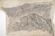
Hungerford
This drawing describes the borders of the counties of Berkshire, Hampshire and Wiltshire. Their boundaries are marked by red pecked lines, as a note at the base of the drawing explains. The draughtsman has detailed the star-shaped path formation of Savernake Forest, a great royal hunting forest, and recorded the Roman road between Marton and Titcombe. Chisbury, an iron-age hillfort, is marked by concentric rings to the right of Savernake Forest, although the recording of archaeological features did not become obligatory until 1816. To the left of Shalbourne, a windmill is shown in elevation.
Map of Hampshire, including the Isle of Wight, 1
1 Blatt : 55 x 68 cm s.n.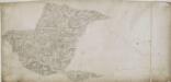
Alresford 19
1 : 31680 Relief is indicated on this plan by shading and interlining ('hachuring'). The concern with depicting relief accurately reflects the military emphasis of these drawings: knowledge of the lie of the land could greatly help the efficient movement of regiments. The right-hand side of the drawing is unfinished, featuring main roads only.
Winchester - OS One-Inch Map
1 : 63360 Topographic maps Ordnance Survey Ordnance Survey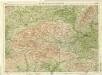
Berkshire, Sheet 29 - Bartholomew's "Half Inch to the Mile Maps" of England & Wales
1 : 126720 Topographic maps Bartholomew, John George John Bartholomew & Co
BERCHERIA | Vernacule | BARK SHIRE.
[Amsterdam : Joan Blaeu]
Hantonia sive Sovthantonensis comitatvs vulgo Hant-shire
1 Karte : Kupferdruck ; 40 x 48 cm Blaeu Joan Blaeu
WILTONIA | sive | COMITATVS WILTONI- | ENSIS; Anglis | WIL SHIRE.
[Amsterdam : Joan Blaeu]
Bercheria Vernacule Bark Shire. [Karte], in: Theatrum orbis terrarum, sive, Atlas novus, Bd. 4, S. 186.
1 Karte aus Atlas Blaeu, Joan Blaeu, Willem Janszoon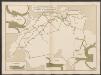
Bercheria Vernacule Barkshire. [Karte], in: Le théâtre du monde, ou, Nouvel atlas contenant les chartes et descriptions de tous les païs de la terre, Bd. 4, S. 164.
1 Karte aus Atlas Blaeu, Willem Janszoon und Blaeu, Joan Blaeu, Willem Janszoon
Bercheria Vernacule Bark Shire. [Karte], in: Theatrum orbis terrarum, sive, Atlas novus, Bd. 4, S. 186.
1 Karte aus Atlas Blaeu, Joan Blaeu, Willem Janszoon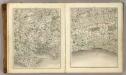
Sheets 15-16. (Cary's England, Wales, and Scotland).
1 : 360000 Cary, John, ca. 1754-1835
A new improved map of Hampshire
1 Karte : Kupferdruck ; 51 x 67 cm Kitchin; Hinton sold by I. Hinton at the Kings Arms in St. Pauls Church Yard