Maps of Lewisham
London XII.83 - OS London Town Plan
1 : 1056 Topographic maps Ordnance Survey Ordnance Survey
Kent VII.8 (includes: Lewisham) - 25 Inch Map
1 : 2500 Topographic maps Ordnance Survey Ordnance Survey
London (1915- Numbered sheets) X.13 (includes: Lewisham) - 25 Inch Map
1 : 2500 Topographic maps Ordnance Survey Ordnance Survey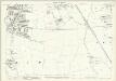
London (Edition of 1894-96) CXXIX (includes: Lewisham) - 25 Inch Map
1 : 2500 Topographic maps Ordnance Survey Ordnance Survey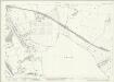
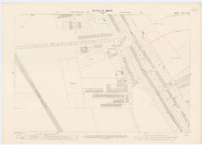
London (1915- Numbered sheets) X.14 (includes: Borough Of Woolwich; Chislehurst and Sidcup; Lewisham) - 25 Inch Map
1 : 2500 Topographic maps Ordnance Survey Ordnance Survey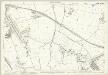
London (Edition of 1894-96) CXXX (includes: Borough Of Woolwich; Chislehurst and Sidcup; Lewisham) - 25 Inch Map
1 : 2500 Topographic maps Ordnance Survey Ordnance Survey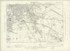
London XII.SW - OS Six-Inch Map
1 : 10560 Topographic maps Ordnance Survey Ordnance Survey
An exact survey of the city's of London Westminster , II
1 Blatt : 53 x 71 cm John Rocque
An exact survey of the city's of London Westminster , I
1 Blatt : 53 x 71 cm John Rocque
London Sheet P - OS Six-Inch Map
1 : 10560 Topographic maps Ordnance Survey Ordnance Survey
London Sheet P - OS Six-Inch Map
1 : 10560 Topographic maps Ordnance Survey Ordnance Survey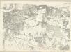
Middlesex XXIII - OS Six-Inch Map
1 : 10560 Topographic maps Ordnance Survey Ordnance Survey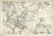
Kent VII - OS Six-Inch Map
1 : 10560 Topographic maps Ordnance Survey Ordnance Survey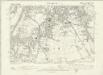
Kent VII.NE - OS Six-Inch Map
1 : 10560 Topographic maps Ordnance Survey Ordnance Survey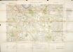
Militärgeographische Angaben über England.
Generalstab des Heeres, Abteilung für Kriegskarten u. Vermessungswesen IV. Mil.-Geo
Bromley (Kent)
1 : 21120 Drawing showing the area around Bromley in Kent. Field boundaries enclosing cultivated land dominate this map of what is now south-east London. Such land is depicted by a striped pattern. Ruled dashed red lines also feature strongly. They radiate from trigonometrical stations used for measuring and plotting topographical features. The signalling telegraph station in Plow Garlic Hill at the top left of the plan marks the site of a trigonometrical station.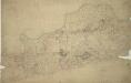
Woolwich
1 : 21120 This drawing covers the south bank of the River Thames from Deptford to Erith. Pencil and red ink rays extending from fixed points are clearly visible on the manuscript, and were used to plot the survey of the area. The numbers 1 to 7 in red ink across the map indicate the position from which field sketches were taken. Buildings are infilled and blocked in red at settlements like Woolwich and Greenwich. Clearly indicated is the Woolwich Warren, site of naval shipbuilding since the early-16th century. Before the Royal Arsenal was officially established there in 1805, the Warren had been home of military armsworks for more than a century.
METROPOLITAN BOROUGHS
This map of London was produced for the 1832 Reform Bill that established the metropolitan boroughs. The map's title features along the top; with a compass star at top right, an explanatory note at bottom right. At bottom left is a list of the 'liberties' of the city - the name given to areas exempt from the jurisdiction of the country sheriff, being subject to a separate commission of the peace (in this case royal and governmental authorities). The new boroughs are highlighted in colour, with the shaded area representing the old boundaries of London, Westminster and Southwark. Dawson, Lieut. Robert K.
A topographical-map, of the county of Kent, No. 1
1 Blatt : 54 x 69 cm A. Dury, W. Herbert
Kaart van Londen enz. en van het naby gelegen land ruim een uur gaans rondom dezelve stad : getrokken uit de groote gemeeten kaart van de Hr. John Rocque
1 : 63500 Amstersdam : Isaak Tirion
The fourth sheet of an actual survey of the county of Middlesex in which the parishes within the bills of mortality are bounded with red to be distinguished from the others
1 Blatt : 53 x 70 cm John Rocque
[Recto], uit: Map of general routes / Fred J.H. Elston
1 : 12500 Elston, Fred J. H. London : General Omnibus Co.
England and Wales, Cities, Ports & Harbours.
1 : 63360 Fullarton, A. & Co.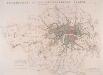
JURISDICTION OF THE METROPOLITAN POLICE
This map illustrates plans for the reform of the jurisdiction of Metropolitan Police. Based on Dawson's map of 1832, the map’s title appear along the top, with compass star at top right, explanatory note at bottom left, and a scale bar at bottom right. District boundaries are highlighted in colour, with the old limits of London, Westminster and Southwark shaded. Formed in 1829, the Metropolitan Police had its jurisdiction extended in 1839to Greater London - an area taken to mean all parishes partly within twelve miles of Charing Cross or wholly within fifteen miles of Charing Cross. In the same year, the City of London formed its own police force. Dawson, Lieut. Robert K.
Plan of a Proposed TURNPIKE ROAD From St. JOHN'S CHAPEL, ST. MARYLEBONE into the Great North Road Near the 8 Mile Stone at Finchley
1 : 31680 Plan of the proposed turnpike road from Regent's Park to Finchley, today's Finchley Road. The plan features title at top right, scale bars at lower right and sections of the road in elevation at the foot of the plate, with the new road represented by a double dotted line coloured red. Down the left of the plate a table gives distances between stations along the road and shows the savings in milage generated by the new road. Phillips, Henry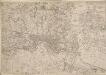
Map of the County of Middlesex in which parishes are bounded with red to be distinguished from the others
The title is missing from this copy of the map. The gives a list of parishes within the Bill of Mortality in scroll at top right with parish boundaries outlined in colour. Land use and reliefs are expressed by symbols, with the built-up area within the City of London represented by stippling. Rocque, John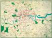
The Lancet Map of Medical London

Map of London [showing] work of the Metropolitan Public Gardens Association, November, 1882, to December, 1900. Scale of miles, 1 1/2[ = 2 1/4 inches]

A Map of London showing the proportion of the inhabitants of each registration sub-district in 1881, born in other parts of the United Kingdom

Dartford (Hills) - OS One-Inch Revised New Series
1 : 63360 Topographic maps Ordnance Survey Ordnance Survey