Maps of Greenwich
London XII.28 - OS London Town Plan
1 : 1056 Topographic maps Ordnance Survey Ordnance Survey
London XII.NE - OS Six-Inch Map
1 : 10560 Topographic maps Ordnance Survey Ordnance Survey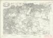
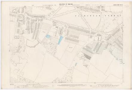
London Sheet P - OS Six-Inch Map
1 : 10560 Topographic maps Ordnance Survey Ordnance Survey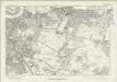
London Sheet P - OS Six-Inch Map
1 : 10560 Topographic maps Ordnance Survey Ordnance Survey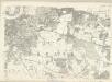
Middlesex XXIII - OS Six-Inch Map
1 : 10560 Topographic maps Ordnance Survey Ordnance Survey
Kent II - OS Six-Inch Map
1 : 10560 Topographic maps Ordnance Survey Ordnance Survey
TQ47 - OS 1:25,000 Provisional Series Map
1 : 25000 Topographic maps Ordnance Survey Ordnance Survey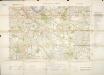
Militärgeographische Angaben über England.
Generalstab des Heeres, Abteilung für Kriegskarten u. Vermessungswesen IV. Mil.-Geo
Bromley (Kent)
1 : 21120 Drawing showing the area around Bromley in Kent. Field boundaries enclosing cultivated land dominate this map of what is now south-east London. Such land is depicted by a striped pattern. Ruled dashed red lines also feature strongly. They radiate from trigonometrical stations used for measuring and plotting topographical features. The signalling telegraph station in Plow Garlic Hill at the top left of the plan marks the site of a trigonometrical station.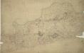
Woolwich
1 : 21120 This drawing covers the south bank of the River Thames from Deptford to Erith. Pencil and red ink rays extending from fixed points are clearly visible on the manuscript, and were used to plot the survey of the area. The numbers 1 to 7 in red ink across the map indicate the position from which field sketches were taken. Buildings are infilled and blocked in red at settlements like Woolwich and Greenwich. Clearly indicated is the Woolwich Warren, site of naval shipbuilding since the early-16th century. Before the Royal Arsenal was officially established there in 1805, the Warren had been home of military armsworks for more than a century.
A topographical-map, of the county of Kent, No. 1
1 Blatt : 54 x 69 cm A. Dury, W. Herbert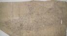
Dartford, Kent
Details of this drawing are corrected in heavy black ink with crosses placed over incorrect field boundaries and communication routes. Red pecked lines form a grid over the drawing. These are triangulation lines, which the draughtsman used to plot features of the landscape. A characteristically straight Roman road is shown leading from Dartford. In the bottom right, the scale is recorded and area calculations laid out.
England and Wales, Cities, Ports & Harbours.
1 : 63360 Fullarton, A. & Co.
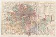
Map of the County of Middlesex in which parishes are bounded with red to be distinguished from the others
The title is missing from this copy of the map. The gives a list of parishes within the Bill of Mortality in scroll at top right with parish boundaries outlined in colour. Land use and reliefs are expressed by symbols, with the built-up area within the City of London represented by stippling. Rocque, John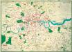
The Lancet Map of Medical London

A Map of London showing the proportion of the inhabitants of each registration sub-district in 1881, born in other parts of the United Kingdom

Dartford (Hills) - OS One-Inch Revised New Series
1 : 63360 Topographic maps Ordnance Survey Ordnance Survey
Dartford (Outline) - OS One-Inch Revised New Series
1 : 63360 Topographic maps Ordnance Survey Ordnance Survey
[Recto], uit: L.C.C. trams
1 : 50000 titelvariant: The tramways pocket map & timetable; Annotatie: Omslagtitel: The tramways pocket map & timetable London County Council [London : London County Council]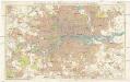
Stanford's new two inch map of London and its environs
1 : 31680 Londýn (Anglie) Edward Stanford
[Recto], uit: Route map and guide : [London]
1 : 50000 London : London General Omnibus Co.
LONDON AND ITS ENVIRONS 241
This is a later edition of the map of London and the suburbs first issued by Davies in 1840. The map features title in top border, scale bar at bottom centre and key to symbols below the map. A note below the map states that the map contains "the boundaries of the Metropolitan Boroughs, the different railroads and stations, the new cemeteries and roads, docks, canals and all the modern improvements. The map is chiefly drawn from the Ordnance Survey, the railroads and the other improvements from the official copies and the Borough of Marylebone from the survey published by Mr Britton. The whole corrected from personal observations and measurements." Davies, Benjamin Rees
LONDON AND ITS ENVIRONS 248
This is a later edition of the map of London and the suburbs first issued by Davies in 1840. The map features title in top border, scale bar at bottom centre and key to symbols below the map. A note below the map states that the map contains "the boundaries of the Metropolitan Boroughs, the different railroads and stations, the new cemeteries and roads, docks, canals and all the modern improvements. The map is chiefly drawn from the Ordnance Survey, the railroads and the other improvements from the official copies and the Borough of Marylebone from the survey published by Mr Britton. The whole corrected from personal observations and measurements. “Borough and county boundaries are highlighted in colour, with principal roads represented in yellow. Davies, Benjamin, Rees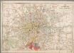
[Kaart], uit: Bartholomew's road surface map of London & neighbourhood
1 : 30000 Edinburgh : Bartholomew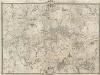
An Exact Survey of the Citys of London, Westminster, ye Borough of Southwark, and the Country near Ten Miles round
This map was first published by Rocque in 1746, and several editions appeared before his death in 1762. His widow Mary Ann carried on the business for a few years, until, in the late 1760s, she transferred the plates of the map to the publishers Carrington Bowles and Robert Sayer, under whose imprints this edition appeared in 1769. Printed in 16 sheets, the map is set within a decorative border. Its title features in English, Latin and French along the top, with emblematic figures below the City arms at top centre, and the compass star at top left. The map is dedicated to Lord Burlington at bottom centre. Scales are given at the foot of the map in versts, leagues, toises, yards and miles. A key to symbols distinguishing orchards, arable land, formal parkland and gardens, pasture, and woodland is included at bottom right. The "New Road" (Marylebone Road), Blackfriars Bridge and the roads across St George's Fields are also shown. Rocque, John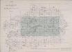
INDEX TO THE PLAN OF LONDON MADE FOR The Metropolitan Commissioners of Sewers
This map's title and imprint feature at top left, with an explanatory note at bottom right and scale bar at bottom centre. The map is divided into rectangles, forming the index to two "London and its Environs" Ordnance Survey maps. The cholera outbreaks of the 1830s and 40s forced the government to improve London drainage and sewage disposal. The Commission of Sewers was established to combine seven of the eight existing sewage companies into one, unifying their drainage systems. Metropolitan Commission of Sewers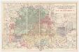
Map of London and its environs : shewing the boundary of the jurisdiction of the metropolitan board of work, also the boundaries of the city of London : Gas companies’ districts
1 : 31680 Standford, Edward, 1827-1904 Edward Standford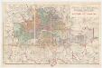
Map of London and its environs : shewing the boundary of the jurisdiction of the metropolitan board of work, also the boundaries of the city of London : Parliamentary boroughs
1 : 31680 Standford, Edward, 1827-1904 Edward Standford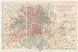
Map of London and its environs : shewing the boundary of the jurisdiction of the metropolitan board of work, also the boundaries of the city of London : Water companies’ district
1 : 31680 Standford, Edward, 1827-1904 Edward Standford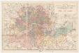
Map of London and its environs : shewing the boundary of the jurisdiction of the metropolitan board of work, also the boundaries of the city of London : Poor law unions
1 : 31680 Standford, Edward, 1827-1904 Edward Standford