Mapa catalogado
London XI.5 - OS London Town Plan
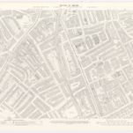

Título completo:London XI.5 - OS London Town Plan
Año de ilustración:1893
Fecha de publicación:1895
Editorial:Ordnance Survey
Tamaño físico:20 x 30 cm
Escala del mapa:1:1 056

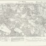
Surrey III.SW - OS Six-Inch Map
1893
Ordnance Survey
1:11k

Surrey VIII.NW - OS Six-Inch Map
1893
Ordnance Survey
1:11k

Surrey VIII.SW & SE - OS Six-Inch Map
1938
Ordnance Survey
1:11k
Surrey VIII.SW & SE - OS Six-Inch Map
1933
Ordnance Survey
1:11k
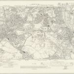
Surrey VIII.SW & SE - OS Six-Inch Map
1910
Ordnance Survey
1:11k

Surrey VIII.SW - OS Six-Inch Map
1893
Ordnance Survey
1:11k
An exact survey of the city's of London Westminster , VII
1761
John Rocque

London Sheet O - OS Six-Inch Map
1938
Ordnance Survey
1:11k

London Sheet O - OS Six-Inch Map
1913
Ordnance Survey
1:11k

Middlesex XXII - OS Six-Inch Map
1868
Ordnance Survey
1:11k