Maps of London
London VIII.1 - OS London Town Plan
1 : 1056 Topographic maps Ordnance Survey Ordnance Survey
Essex (New Series 1913-) n LXXXVI.1 (includes: Cann Hall; West Ham) - 25 Inch Map
1 : 2500 Topographic maps Ordnance Survey Ordnance Survey
London (Edition of 1894-96) XLII (includes: Cann Hall; West Ham) - 25 Inch Map
1 : 2500 Topographic maps Ordnance Survey Ordnance Survey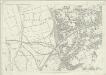
London (First Editions c1850s) XX (includes: Cann Hall; West Ham) - 25 Inch Map
1 : 2500 Topographic maps Ordnance Survey Ordnance Survey
Essex LXXIII.NW - OS Six-Inch Map
1 : 10560 Topographic maps Ordnance Survey Ordnance Survey
London VIII.NW - OS Six-Inch Map
1 : 10560 Topographic maps Ordnance Survey Ordnance Survey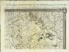
An exact survey of the city's of London Westminster , IV
1 Blatt : 53 x 71 cm John Rocque
Essex LXXIII - OS Six-Inch Map
1 : 10560 Topographic maps Ordnance Survey Ordnance Survey
London Sheet L - OS Six-Inch Map
1 : 10560 Topographic maps Ordnance Survey Ordnance Survey
London Sheet L - OS Six-Inch Map
1 : 10560 Topographic maps Ordnance Survey Ordnance Survey
Plan showing the sewers in Tower Hamlets, 1843
From 1807, the East End was supplied with water pumped from the River Lea at Bow by the East London Waterworks Company. This was not, however, the continuous flow of water we take for granted today. Dr John Simon wrote, in 1849, of the thousands who "wholly depend on their power of attending at some fixed hour of the day, pail in hand, beside the nearest standcock; where, with their neighbours, they wait their turn; sometimes not without a struggle, during the tedious dribbling of a single small pipe. Household rubbish was piled into heaps in the street and outdoor toilets drained into cesspits. The survey of sanitation in Bethnal Green made by Hector Gavin in 1848 paints a sorry picture. Knightly Court was typical of the streets he visited: "In it there are two privies in a beastly state, full, and the contents overflowing into the court. There is one dust reservoir. One stand-tap supplies the seven houses; two cases of severe typhus lately occurred here, one died." This map of 1843 shows the distribution of sewers through the East End. They carried only surface water, contaminated with decayed rubbish from the streets and excrement from overflowing cesspits, and discharged it directly into the Thames - from which water companies pumped their drinking water. James Beek
TQ38 - OS 1:25,000 Provisional Series Map
1 : 25000 Topographic maps Ordnance Survey Ordnance Survey
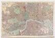
PLAN of LONDON
Only the main roads appear on this map, giving the appearance of a rather spacious capital city. The new London Bridge is shown without its approaches. Pecked lines show the intended location of the Thames Tunnel. Marc Brunel, father of the great engineer Isobard, solved the problem of how to bore through soft ground or under water, inventing the tunnelling shield. Both father and son worked on the tunnel which was completed as a foot tunnel in 1843, before becoming a railway tunnel for the East London Railway in the 1860s. The East and West India Docks are also shown. Phillips, Horatio
Map of London, shewing the BOUNDARIES of the GENERAL and Two Penny Post
This outline map of London was commissioned by the House of Commons for the21st Report of the Commissioners of Revenue Inquiry in 1830. The map's title features at top right, with the boundaries of the nine postal districts and those of the General-, Two- and Three-Penny Post deliveries outlined in colour. Boundaries are explained at top left with a key to colour usage in panel below the plan. Basire, James
Cary's new plan of London and its vicinity
Cary, John; Cary, George Cary
CRUCHLEY'S NEW POSTAL DISTRICT MAP OF LONDON
This map shows the division of London into ten post codes. The title appears along the top, with the publisher's imprint below the plan and a scale bar at bottom left. Also on the map are the Metropolitan Railway line to Finsbury, the proposed site of Charing Cross station (built in 1864) and the planned London, Chatham and Dover line. Cruchley, George Frederick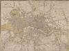
LAURIE and WHITTLE NEW MAP OF LONDON WITH ITS ENVIRONS &C. Including the Recent Improvements
The title of this map of London and suburbs appears at top left, with the key to symbols and abbreviations at the top right and a compass rose at the bottom centre. The map is divided into mile squares with borders marked off in furlongs for reference. Squares, open spaces and city boundaries are distinguished in colour. This is a later edition of a map first issued in 1804, updated to include the new bridges and the approaches at Waterloo and Vauxhall (indicated by dotted lines). Built between 1809 and 1819, Vauxhall, Waterloo and Southwark bridges were projected, funded and constructed by private commercial companies hoping to profit from toll-paying traffic from Lambeth, Camberwell and the rest of south London. Laurie, Robert and Whittle, James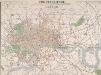
THE CIRCUITEER. A SERIES OF DISTANCE MAPS FOR ALL THE PRINCIPAL TOWNS IN THE UNITED KINGDOM. INVENTED BY J. FREDERICHS AS A GUIDE FOR ASCERTAINING CAB FARES, PORTERAGE &c. &c.
The title of this map of Victorian London appears at top centre, with a scale bar at the foot of the plate. The map is divided into circles, each a half-mile in diameter, allowing the reader to ascertain the distance between two places at a glance. Each circle is also numbered for reference, with a key to the principal streets and squares a in panel below the map, together with an explanatory note. Repeated in French and German, this note reports London cab fares, set by Act of Parliament at 8d (pence) per mile and 4d for every additional half mile. Frederichs, J.
LAURIE'S NEW PLAN OF LONDON and its ENVIRONS with an Improved Scale FOR ASCERTENING DISTANCES
Map of London and the suburbs with title, imprint and dedication to Lord Viscount Melbourne in table at top right. Below the title, a note explaining that the map was based on the trigonometric survey by General Roy "combined with a new series of 52 stations on elevated situations from which the positions of upward to of 450 steeples, domes, turrets, vanes and other conspicuous objects within the limits of the plan, have been determined by means of more than 5000 angles." Laurie, Richard Holmes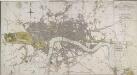
LONDON IN MINIATURE WITH THE Surrounding AN ENTIRE NEW PLAN In which the Improvements both present and intended are actually reduced (by permission) from the surveys of Several Proprietors
The title of this map appears at top right, with scale bar at the bottom centre, and a compass rose near top left. Watercourses, roads and open spaces are depicted in colour. The map shows the proposed new bridges at Waterloo and Vauxhall, extending eastward on an added sheet to include the Isle of Dogs. Mogg, Edward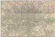
Bez titulu: London
LAURIE and WHITTLE'S NEW MAP OF LONDON WITH ITS ENVIRONS
This is a later edition of Laurie and Whittle's folding map of London, first published in 1804. The title appears as an old inscription on an illustrated pyramid at top left, also showing city arms, ship, flag, anchor, flora and fauna. Explanation of symbols and abbreviations is given above the publisher's imprint at top right, with compass star at bottom centre. The border of the map is marked off in furlongs. Proposed works, including the Vauxhall and Waterloo bridges and their approaches, are highlighted in yellow. Laurie, Robert and Whittle, James
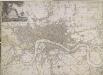
A New Map of LONDON and its ENVIRONS From an Original Survey
This London Map comprises two sheets, with title at top right, imprint below the title, compass star at middle right and the scale bar at bottom left. Set within a decorative border, the map extends beyond the built-up area of the city to include parts of Middlesex, Surrey, the Lea River Valley and Greenwich. Thompson, George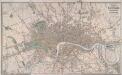
LAURIE'S PLAN OF LONDON, WESTMINSTER AND SOUTHWARK Trigonometrically Surveyed by JOHN OUTHETT
This is a later edition of the folding map first issued by Laurie in 1837. The map features title at top right, key to colours and scale of 40 acres at bottom centre. The border of the map is divided in miles and furlongs from St Paul's Cathedral and seconds of longitude east and west of Greenwich. Laurie, Richard Holmes
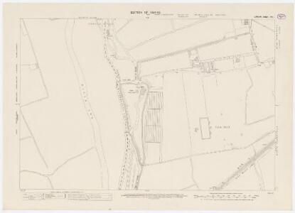
Stratford - Le - Bow
1 : 21120 This plan of north east London extends from the Isle of Dogs and Wapping at the bottom, to 'Layton Stone' and Epping Forest at the top. Field boundaries infilled with stripes depict tilled land. Major settlements are drawn in red ink. North of Stoke Newington, to the top left, a road is plotted as a series of fixed points pricked off with dividers and joined by ruled pencil lines. These protractions were made directly from the Ordnance Survey field books. Pencil rays intersect across the map, evidence of measurements taken by the surveyor between fixed triangulation points. Poplar Gut is outlined in red at the Isle of Dogs, the beginnings of the development of the West India Docks.
NEW PLAN OF LONDON AND THE ENVIRONS from an Original Survey EXTENDING 6 3/4 Miles North & South in which all New and Intended Buildings and Improvements are carefully Inserted
This folding map is set within a decorative border. The title and imprint feature at top right, the compass star at middle right, and scale bar at bottom left. The river, open spaces and the built-up area in the city are delineated in colour. This is the fourth edition of a map first issued by Thompson in 1823, updated with the addition of St. Katherine's Dock and the housing developments in the Marylebone and Mile End areas. Thompson, George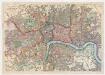
Bacon's map of London : with railways in operation and constructing corrected to date
Bacon & Co Bacon & Co.
London [11], uit: Geognostische Karte des Oesterreichischen Kaiserstaates mit einem grossen Theile Deutschland's u. Italien / hauptsachlich nach ... Haidinger's geognostischer Karte dieses Staates bearb. von Josef Scheda
1 : 3000000 titelvariant: General-Karte von Europa in 25 Blättern; Annotatie: Bijlage bij: General-Karte von Europa in 25 Blättern. - 1:2.592.000. - 1845-1847 Scheda, Joseph Wien : K.K. Militär. Geografisch. Institut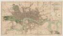
London in miniature : with the surrounding villages, an entire new plan in which the improvements both present and intended are actually reduced (by permission) from the surveys of the several proprietors : the whole laide down from the best authorities
1 : 16000 Mogg, Edward Edward Mogg