Maps of Camden
London VII.33 - OS London Town Plan
1 : 1056 Topographic maps Ordnance Survey Ordnance Survey
A Plan of Ground to be let at Somers Place in the Parish of St. Pancras.

Insurance Plan of London North North West District Vol. D: sheet 8-2
1 : 480 This detailed 1892 plan of London is one of a series of eight sheets in an atlas originally produced to aid insurance companies in assessing fire risks. The building footprints, their use (commercial, residential, educational, etc.), the number of floors and the height of the building, as well as construction materials (and thus risk of burning) and special fire hazards (chemicals, kilns, ovens) were documented in order to estimate premiums. Names of individual businesses, property lines, and addresses were also often recorded. Together these maps provide a rich historical shapshot of the commercial activity and urban landscape of towns and cities at the time. The British Library holds a comprehensive collection of fire insurance plans produced by the London-based firm Charles E. Goad Ltd. dating back to 1885. These plans were made for most important towns and cities of the British Isles at the scales of 1:480 (1 inch to 40 feet), as well as many foreign towns at 1:600 (1 inch to 50 feet). Chas E Goad Limited Chas E Goad Limited
Insurance Plan of London Vol. xi: sheet 398-2
1 : 480 This detailed 1891 plan of London is one of a series of forty seven sheets in an atlas originally produced to aid insurance companies in assessing fire risks. The building footprints, their use (commercial, residential, educational, etc.), the number of floors and the height of the building, as well as construction materials (and thus risk of burning) and special fire hazards (chemicals, kilns, ovens) were documented in order to estimate premiums. Names of individual businesses, property lines, and addresses were also often recorded. Together these maps provide a rich historical shapshot of the commercial activity and urban landscape of towns and cities at the time. The British Library holds a comprehensive collection of fire insurance plans produced by the London-based firm Charles E. Goad Ltd. dating back to 1885. These plans were made for most important towns and cities of the British Isles at the scales of 1:480 (1 inch to 40 feet), as well as many foreign towns at 1:600 (1 inch to 50 feet). Chas E Goad Limited Chas E Goad Limited
Insurance Plan of London North North West District Vol. D: sheet 8-1
1 : 480 This detailed 1892 plan of London is one of a series of eight sheets in an atlas originally produced to aid insurance companies in assessing fire risks. The building footprints, their use (commercial, residential, educational, etc.), the number of floors and the height of the building, as well as construction materials (and thus risk of burning) and special fire hazards (chemicals, kilns, ovens) were documented in order to estimate premiums. Names of individual businesses, property lines, and addresses were also often recorded. Together these maps provide a rich historical shapshot of the commercial activity and urban landscape of towns and cities at the time. The British Library holds a comprehensive collection of fire insurance plans produced by the London-based firm Charles E. Goad Ltd. dating back to 1885. These plans were made for most important towns and cities of the British Isles at the scales of 1:480 (1 inch to 40 feet), as well as many foreign towns at 1:600 (1 inch to 50 feet). Chas E Goad Limited Chas E Goad Limited
SKETCH PLAN AS LAID OUT FOR BUILDING HOUSES OF THE SECOND AND THIRD RATE OF BUILDINGS AT BATTLE BRIDGE, THE PROPERTY OF ROBERT Mc WILLIAM AND THE TRUSTEES UNDER HIS MARRIAGE SETTLEMENT.
Plan for proposed new buildings at Battle Bridge, the site where King's Cross railway station now stands. Standidge & Lemon
Insurance Plan of London Vol. xi: sheet 400-1
1 : 480 This detailed 1891 plan of London is one of a series of forty seven sheets in an atlas originally produced to aid insurance companies in assessing fire risks. The building footprints, their use (commercial, residential, educational, etc.), the number of floors and the height of the building, as well as construction materials (and thus risk of burning) and special fire hazards (chemicals, kilns, ovens) were documented in order to estimate premiums. Names of individual businesses, property lines, and addresses were also often recorded. Together these maps provide a rich historical shapshot of the commercial activity and urban landscape of towns and cities at the time. The British Library holds a comprehensive collection of fire insurance plans produced by the London-based firm Charles E. Goad Ltd. dating back to 1885. These plans were made for most important towns and cities of the British Isles at the scales of 1:480 (1 inch to 40 feet), as well as many foreign towns at 1:600 (1 inch to 50 feet). Chas E Goad Limited Chas E Goad Limited
Goad Fire Insurance Plan of London
London: Chas. E. Goad
Insurance Plan of London Vol. xi: sheet 398-1
1 : 480 This detailed 1891 plan of London is one of a series of forty seven sheets in an atlas originally produced to aid insurance companies in assessing fire risks. The building footprints, their use (commercial, residential, educational, etc.), the number of floors and the height of the building, as well as construction materials (and thus risk of burning) and special fire hazards (chemicals, kilns, ovens) were documented in order to estimate premiums. Names of individual businesses, property lines, and addresses were also often recorded. Together these maps provide a rich historical shapshot of the commercial activity and urban landscape of towns and cities at the time. The British Library holds a comprehensive collection of fire insurance plans produced by the London-based firm Charles E. Goad Ltd. dating back to 1885. These plans were made for most important towns and cities of the British Isles at the scales of 1:480 (1 inch to 40 feet), as well as many foreign towns at 1:600 (1 inch to 50 feet). Chas E Goad Limited Chas E Goad Limited
Insurance Plan of London Vol. xi: sheet 399-1
1 : 480 This detailed 1891 plan of London is one of a series of forty seven sheets in an atlas originally produced to aid insurance companies in assessing fire risks. The building footprints, their use (commercial, residential, educational, etc.), the number of floors and the height of the building, as well as construction materials (and thus risk of burning) and special fire hazards (chemicals, kilns, ovens) were documented in order to estimate premiums. Names of individual businesses, property lines, and addresses were also often recorded. Together these maps provide a rich historical shapshot of the commercial activity and urban landscape of towns and cities at the time. The British Library holds a comprehensive collection of fire insurance plans produced by the London-based firm Charles E. Goad Ltd. dating back to 1885. These plans were made for most important towns and cities of the British Isles at the scales of 1:480 (1 inch to 40 feet), as well as many foreign towns at 1:600 (1 inch to 50 feet). Chas E Goad Limited Chas E Goad Limited
Insurance Plan of London Vol. xi: sheet 372-2
1 : 480 This detailed 1891 plan of London is one of a series of forty seven sheets in an atlas originally produced to aid insurance companies in assessing fire risks. The building footprints, their use (commercial, residential, educational, etc.), the number of floors and the height of the building, as well as construction materials (and thus risk of burning) and special fire hazards (chemicals, kilns, ovens) were documented in order to estimate premiums. Names of individual businesses, property lines, and addresses were also often recorded. Together these maps provide a rich historical shapshot of the commercial activity and urban landscape of towns and cities at the time. The British Library holds a comprehensive collection of fire insurance plans produced by the London-based firm Charles E. Goad Ltd. dating back to 1885. These plans were made for most important towns and cities of the British Isles at the scales of 1:480 (1 inch to 40 feet), as well as many foreign towns at 1:600 (1 inch to 50 feet). Chas E Goad Limited Chas E Goad Limited
Insurance Plan of London North West District Vol. C: Index Key Plan A
1 : 480 This "key plan" indicates coverage of the Goad 1900 series of fire insurance maps of London that were originally produced to aid insurance companies in assessing fire risks. The building footprints, their use (commercial, residential, educational, etc.), the number of floors and the height of the building, as well as construction materials (and thus risk of burning) and special fire hazards (chemicals, kilns, ovens) were documented in order to estimate premiums. Names of individual businesses, property lines, and addresses were also often recorded. Together these maps provide a rich historical shapshot of the commercial activity and urban landscape of towns and cities at the time. The British Library holds a comprehensive collection of fire insurance plans produced by the London-based firm Charles E. Goad Ltd. dating back to 1885. These plans were made for most important towns and cities of the British Isles at the scales of 1:480 (1 inch to 40 feet), as well as many foreign towns at 1:600 (1 inch to 50 feet). Chas E Goad Limited Chas E Goad Limited
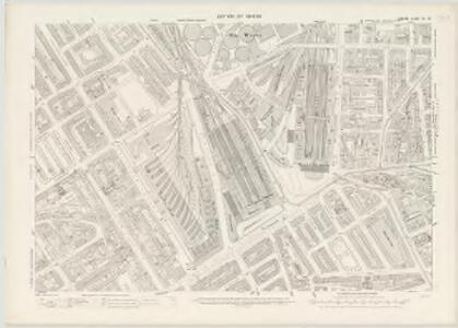
London (1915- Numbered sheets) V.5 (includes: St Marylebone; St Pancras) - 25 Inch Map
1 : 2500 Topographic maps Ordnance Survey Ordnance Survey
London (First Editions c1850s) XXV (includes: St Marylebone; St Pancras) - 25 Inch Map
1 : 2500 Topographic maps Ordnance Survey Ordnance Survey
London (1915- Numbered sheets) V.6 (includes: Finsbury; Holborn; Islington; St Pancras) - 25 Inch Map
1 : 2500 Topographic maps Ordnance Survey Ordnance Survey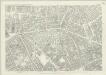
London (First Editions c1850s) XXVI (includes: Finsbury; Holborn; Islington; St Pancras) - 25 Inch Map
1 : 2500 Topographic maps Ordnance Survey Ordnance Survey
A Plan of the intended IMPROVEMENTS, on the Estate of his Grace the Duke of BEDFORD. 1800 16
1 : 2784 The area of Bloomsbury represented in this plan has been part of the metropolitan estate of the Russell family, the Earls and Dukes of Bedford since the 17th century. Many of the names of the streets and squares reflect this connection. The plan shows the old British Museum simply marked ''museum'', Russell Square, Brunswick Square, Tavistock Square, Nursery Ground are all indicated as green spaces. Bloomsbury square is marked by a pecked line and coloured green. Bedford house has become Bedford Place, constructed in 1801-5 by James Burton. Under the 6th Duke of Bedford the area was developed north and east, principally by James Burton and Thomas Cubitt. The resulting squares became a favourite area for writers and painters. Neele
Insurance Plan of London North North West District Vol. D: sheet 9
1 : 480 This detailed 1892 plan of London is one of a series of eight sheets in an atlas originally produced to aid insurance companies in assessing fire risks. The building footprints, their use (commercial, residential, educational, etc.), the number of floors and the height of the building, as well as construction materials (and thus risk of burning) and special fire hazards (chemicals, kilns, ovens) were documented in order to estimate premiums. Names of individual businesses, property lines, and addresses were also often recorded. Together these maps provide a rich historical shapshot of the commercial activity and urban landscape of towns and cities at the time. The British Library holds a comprehensive collection of fire insurance plans produced by the London-based firm Charles E. Goad Ltd. dating back to 1885. These plans were made for most important towns and cities of the British Isles at the scales of 1:480 (1 inch to 40 feet), as well as many foreign towns at 1:600 (1 inch to 50 feet). Chas E Goad Limited Chas E Goad Limited
London VII.NW - OS Six-Inch Map
1 : 10560 Topographic maps Ordnance Survey Ordnance Survey
Militärgeographische Angaben über England.
Generalstab des Heeres, Abteilung für Kriegskarten u. Vermessungswesen IV. Mil.-Geo
A Plan of the New Intended Road from Paddington to Islington.

A Plan of te Parish of ST MARY ISLINGTON, with the boundaries of the Several Ecclesiastical Districts, Sueveyed by R. Creighton for the Parochial History, BY S. LEWIS, JUNR.
1 : 15840 Plan of the parish of St Mary's Islington, with the nine ecclesiastical districts that make up the parish delineated by pastel colours. Dower, John, Pentonville.
Charles Booth's descriptive map of London poverty 1889
Charles Booth
PLAN OF THE PARISH OF ST. MARYLEBONE with the Improvements proposed ON THE MARYLEBONE PARK ESTATE WITH THE CONTIGUOUS PARTS of the Parish of St. Pancras
1 : 5333 Plan of the Parish of St. Marylebone with title at bottom left and explanatory note at bottom right describing proposals for building houses and gardens on land belonging to the Crown along the New Road. White, John
Insurance Plan of London North District Vol. D: Key Plan
1 : 3600 This "key plan" indicates coverage of the Goad 1901 series of fire insurance maps of London that were originally produced to aid insurance companies in assessing fire risks. The building footprints, their use (commercial, residential, educational, etc.), the number of floors and the height of the building, as well as construction materials (and thus risk of burning) and special fire hazards (chemicals, kilns, ovens) were documented in order to estimate premiums. Names of individual businesses, property lines, and addresses were also often recorded. Together these maps provide a rich historical shapshot of the commercial activity and urban landscape of towns and cities at the time. The British Library holds a comprehensive collection of fire insurance plans produced by the London-based firm Charles E. Goad Ltd. dating back to 1885. These plans were made for most important towns and cities of the British Isles at the scales of 1:480 (1 inch to 40 feet), as well as many foreign towns at 1:600 (1 inch to 50 feet). Chas E Goad Limited Chas E Goad Limited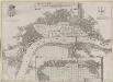
Grundstriss der Statt LONDON wie solche vor und nach dem Brand anzuschen sampt dem Newen Model wie selbige wid rum Auffgebauwet werden solle
This is a map of London immediately after the great fire of 1666. The map was first published by the Merian Heirs of Frankfurt in 1677, appearing in the anthology "Theatri Europei". The title appears in a scroll along the top, flanked by royal and city arms. Notes on shading and an inset plan of Robert Hooke’s designs for rebuilding the city appear in another scroll at the foot of the plate. Hooke's plan is given with its own key and reference table.
LONDON 206
This plan for a survey of London was published in Volume VIII of ‘Encyclopaedia Londinensis' in 1814. The plan's title appears above the plan, with a compass star at the top right. St. Paul's Cathedral and other prominent buildings are shown pictorially, with other places of interest indicated by numbers. Jones, George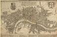
A POCKET MAP OF LONDON, WESTMINSTER AND SOUTHWARK With ye New Buildings to ye Year 1739
The map's title appears in English and Dutch in a panel along the top. A descriptive note features below the title, with royal arms at top left, city arms at top right and fares of hackney coaches and water ferries in a panel below the plan. The map shows the new bridge at Westminster and represents prominent buildings and landmark three-dimensionally. De Leth, Hendrick
PLATTE GRONDT Der Verbrande Stadt LONDON
This map was published in Amsterdam aftermath the great fire of 1666. The title in a banner at top right, flanked by City and Royal arms. The design for rebuilding the City is inset in a panel at top left, with an engraved view of the fire in a banner at bottom centre. Below the plan is a description of the fire in Dutch, French and English with a key to streets and buildings. Doornick, Marcus Willemsz