Maps of Camden
London VII.32 - OS London Town Plan
1 : 1056 Topographic maps Ordnance Survey Ordnance Survey
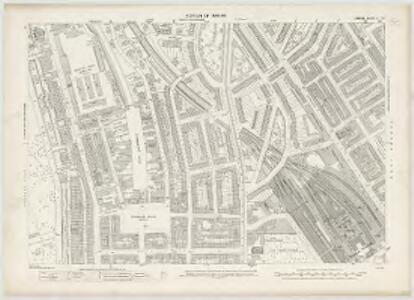
Insurance Plan of London Vol. xi: sheet 408
1 : 480 This detailed 1891 plan of London is one of a series of forty seven sheets in an atlas originally produced to aid insurance companies in assessing fire risks. The building footprints, their use (commercial, residential, educational, etc.), the number of floors and the height of the building, as well as construction materials (and thus risk of burning) and special fire hazards (chemicals, kilns, ovens) were documented in order to estimate premiums. Names of individual businesses, property lines, and addresses were also often recorded. Together these maps provide a rich historical shapshot of the commercial activity and urban landscape of towns and cities at the time. The British Library holds a comprehensive collection of fire insurance plans produced by the London-based firm Charles E. Goad Ltd. dating back to 1885. These plans were made for most important towns and cities of the British Isles at the scales of 1:480 (1 inch to 40 feet), as well as many foreign towns at 1:600 (1 inch to 50 feet). Chas E Goad Limited Chas E Goad Limited
Insurance Plan of London North West Vol. C: sheet 9-1
1 : 480 This detailed 1889 plan of London is one of a series of nine sheets in an atlas originally produced to aid insurance companies in assessing fire risks. The building footprints, their use (commercial, residential, educational, etc.), the number of floors and the height of the building, as well as construction materials (and thus risk of burning) and special fire hazards (chemicals, kilns, ovens) were documented in order to estimate premiums. Names of individual businesses, property lines, and addresses were also often recorded. Together these maps provide a rich historical shapshot of the commercial activity and urban landscape of towns and cities at the time. The British Library holds a comprehensive collection of fire insurance plans produced by the London-based firm Charles E. Goad Ltd. dating back to 1885. These plans were made for most important towns and cities of the British Isles at the scales of 1:480 (1 inch to 40 feet), as well as many foreign towns at 1:600 (1 inch to 50 feet). Chas E Goad Limited Chas E Goad Limited
Insurance Plan of London North West District Vol. C: Index Key Plan A
1 : 480 This "key plan" indicates coverage of the Goad 1900 series of fire insurance maps of London that were originally produced to aid insurance companies in assessing fire risks. The building footprints, their use (commercial, residential, educational, etc.), the number of floors and the height of the building, as well as construction materials (and thus risk of burning) and special fire hazards (chemicals, kilns, ovens) were documented in order to estimate premiums. Names of individual businesses, property lines, and addresses were also often recorded. Together these maps provide a rich historical shapshot of the commercial activity and urban landscape of towns and cities at the time. The British Library holds a comprehensive collection of fire insurance plans produced by the London-based firm Charles E. Goad Ltd. dating back to 1885. These plans were made for most important towns and cities of the British Isles at the scales of 1:480 (1 inch to 40 feet), as well as many foreign towns at 1:600 (1 inch to 50 feet). Chas E Goad Limited Chas E Goad Limited
London (1915- Numbered sheets) V.5 (includes: St Marylebone; St Pancras) - 25 Inch Map
1 : 2500 Topographic maps Ordnance Survey Ordnance Survey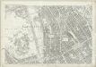
London (First Editions c1850s) XXV (includes: St Marylebone; St Pancras) - 25 Inch Map
1 : 2500 Topographic maps Ordnance Survey Ordnance Survey
Some account of the proposed improvements of the Western part of London, by the formation of the Regent's Park, the new street, the new sewer. ... Illustrated by plans and accompanied by critical observations.

Insurance Plan of London Vol. xi: sheet 372-2
1 : 480 This detailed 1891 plan of London is one of a series of forty seven sheets in an atlas originally produced to aid insurance companies in assessing fire risks. The building footprints, their use (commercial, residential, educational, etc.), the number of floors and the height of the building, as well as construction materials (and thus risk of burning) and special fire hazards (chemicals, kilns, ovens) were documented in order to estimate premiums. Names of individual businesses, property lines, and addresses were also often recorded. Together these maps provide a rich historical shapshot of the commercial activity and urban landscape of towns and cities at the time. The British Library holds a comprehensive collection of fire insurance plans produced by the London-based firm Charles E. Goad Ltd. dating back to 1885. These plans were made for most important towns and cities of the British Isles at the scales of 1:480 (1 inch to 40 feet), as well as many foreign towns at 1:600 (1 inch to 50 feet). Chas E Goad Limited Chas E Goad Limited
Insurance Plan of London North West Vol. C: Key Plan
1 : 480 This "key plan" indicates coverage of the Goad 1889 series of fire insurance maps of London that were originally produced to aid insurance companies in assessing fire risks. The building footprints, their use (commercial, residential, educational, etc.), the number of floors and the height of the building, as well as construction materials (and thus risk of burning) and special fire hazards (chemicals, kilns, ovens) were documented in order to estimate premiums. Names of individual businesses, property lines, and addresses were also often recorded. Together these maps provide a rich historical shapshot of the commercial activity and urban landscape of towns and cities at the time. The British Library holds a comprehensive collection of fire insurance plans produced by the London-based firm Charles E. Goad Ltd. dating back to 1885. These plans were made for most important towns and cities of the British Isles at the scales of 1:480 (1 inch to 40 feet), as well as many foreign towns at 1:600 (1 inch to 50 feet). Chas E Goad Limited Chas E Goad Limited
Insurance Plan of London North West Vol. C: sheet 7
1 : 480 This detailed 1889 plan of London is one of a series of nine sheets in an atlas originally produced to aid insurance companies in assessing fire risks. The building footprints, their use (commercial, residential, educational, etc.), the number of floors and the height of the building, as well as construction materials (and thus risk of burning) and special fire hazards (chemicals, kilns, ovens) were documented in order to estimate premiums. Names of individual businesses, property lines, and addresses were also often recorded. Together these maps provide a rich historical shapshot of the commercial activity and urban landscape of towns and cities at the time. The British Library holds a comprehensive collection of fire insurance plans produced by the London-based firm Charles E. Goad Ltd. dating back to 1885. These plans were made for most important towns and cities of the British Isles at the scales of 1:480 (1 inch to 40 feet), as well as many foreign towns at 1:600 (1 inch to 50 feet). Chas E Goad Limited Chas E Goad Limited
London VII.NW - OS Six-Inch Map
1 : 10560 Topographic maps Ordnance Survey Ordnance Survey
A Plan of the New Intended Road from Paddington to Islington.

Charles Booth's descriptive map of London poverty 1889
Charles Booth
PLAN OF THE PARISH OF ST. MARYLEBONE with the Improvements proposed ON THE MARYLEBONE PARK ESTATE WITH THE CONTIGUOUS PARTS of the Parish of St. Pancras
1 : 5333 Plan of the Parish of St. Marylebone with title at bottom left and explanatory note at bottom right describing proposals for building houses and gardens on land belonging to the Crown along the New Road. White, John
Insurance Plan of London North District Vol. D: Key Plan
1 : 3600 This "key plan" indicates coverage of the Goad 1901 series of fire insurance maps of London that were originally produced to aid insurance companies in assessing fire risks. The building footprints, their use (commercial, residential, educational, etc.), the number of floors and the height of the building, as well as construction materials (and thus risk of burning) and special fire hazards (chemicals, kilns, ovens) were documented in order to estimate premiums. Names of individual businesses, property lines, and addresses were also often recorded. Together these maps provide a rich historical shapshot of the commercial activity and urban landscape of towns and cities at the time. The British Library holds a comprehensive collection of fire insurance plans produced by the London-based firm Charles E. Goad Ltd. dating back to 1885. These plans were made for most important towns and cities of the British Isles at the scales of 1:480 (1 inch to 40 feet), as well as many foreign towns at 1:600 (1 inch to 50 feet). Chas E Goad Limited Chas E Goad Limited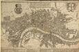
A POCKET MAP OF LONDON, WESTMINSTER AND SOUTHWARK With ye New Buildings to ye Year 1739
The map's title appears in English and Dutch in a panel along the top. A descriptive note features below the title, with royal arms at top left, city arms at top right and fares of hackney coaches and water ferries in a panel below the plan. The map shows the new bridge at Westminster and represents prominent buildings and landmark three-dimensionally. De Leth, Hendrick
London NW.
1 : 15840 Stanford, Edward
PLAN OF ISLINGTON PARISH
1 : 9744 This detailed plan of the parish of Islington records each property and field boundary and even indicates the layout of the gardens and trees. A vignette in the lower right corner shows a view of Canonbury from 1821. The note at lower left reports the increase in building over the last seven years and the population growth. Dent, R.
This Actual Survey Of London Westminster Southwark Is Humbly Dedicated To Ye Ld. Mayor & Court of Aldermen
Morden, Robert; Lea, Philip Covens et Mortier
PLAN of the Parish of St. Mary. Islington
This is a plan of the parish of St Mary's, Islington, with three vignettes depicting the Scotch Church, the New Church and St Peter's Chapel down the right of the plate. Baker, B.
Insurance Plan of London North North West District Vol. D: Key Plan
1 : 10560 This "key plan" indicates coverage of the Goad 1892 series of fire insurance maps of London that were originally produced to aid insurance companies in assessing fire risks. The building footprints, their use (commercial, residential, educational, etc.), the number of floors and the height of the building, as well as construction materials (and thus risk of burning) and special fire hazards (chemicals, kilns, ovens) were documented in order to estimate premiums. Names of individual businesses, property lines, and addresses were also often recorded. Together these maps provide a rich historical shapshot of the commercial activity and urban landscape of towns and cities at the time. The British Library holds a comprehensive collection of fire insurance plans produced by the London-based firm Charles E. Goad Ltd. dating back to 1885. These plans were made for most important towns and cities of the British Isles at the scales of 1:480 (1 inch to 40 feet), as well as many foreign towns at 1:600 (1 inch to 50 feet). Chas E Goad Limited Chas E Goad Limited
The LONDON DIRECTORY, or a New & Improved PLAN of LONDON, WESTMINSTER, & SOUTHWARK;
This is a reissue of a map first published in 1771 by John Bowles. Bowles' name has been removed, with the imprint of there issuer, Robert Wilkinson, appearing instead. This map highlights the London Wall in red, showing with arrows the direction of water-flow in the Thames. Bowles, John
A new PLAN of LONDON, WESTMINSTER and SOUTHWARK 85
This map of London, Westminster and Southwark was published in John Strype's 1720''Survey of the Cities of London and Westminster''. The map's title is at top centre in ornamental cartouche, surrounded by cherubs, fruits and mythological figures. Dedication to Sir George Thorold, Lord Mayor of London appears at top right, facing the city arms at top left. A compass star is depicted at middle right and a scale bar at bottom right. Strype, John
THIS ACTUAL SURVEY OF LONDON, WESTMINSTER & SOUTHWARK IS HUMBLY DEDICATED TO Ye LD MAYOR & COURT OF ALDERMEN
This map is a reissue of a 1690 plan. It features the title in a banner along the top with a compass rose and the city arms. The key to public offices, wards, parishes, halls and companies appear in tables at the bottom and lower right. Prominent buildings shown in elevation. This updated edition includes the Cavendish Square development, which began in 1717. Covens& Mortier was a successful publishing business, including in its output re-issues of general atlases by Jaillot, Delisle, Vichsscher and de Wit, whose stock they had acquired. Covens, Jean & Mortier, Corneille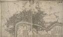
This Actuale Survey of LONDON, WESTMINSTER & SOUTHWARK IS HUMBLY DEDICATED TO Y.e L.D LORD MAYOR & COURT OF ALDERMEN
This later edition of Morden and Lea's 1688 map was published by Covens & Mortier in Amsterdam in 1725. The title appears in English and French in a ribbon along the top. The key to churches, city wards, palaces, halls and companies features in a reference table at the foot of the plate. Jean Covens and Corneil Mortier founded the prestigious printing and publishing house that bears their names in Amsterdam in 1721. Over the years they published wall maps of countries and continents, reissuing many maps, town plans and general atlases by the likes of De Wit, Jaillot and De Lisle. Their heirs continued the business until the 1880s. Morden, Robert & Lea, Philip
The LONDON DIRECTORY, or a New & Improved PLAN of LONDON, WESTMINSTER, & SOUTHWARK
This is the fifth edition of a map originally published in 1771 by John Bowles. His name has been replaced by the imprint of Robert Wilkinson, the reissuer. This map highlights the London Wall in red, and colours the city in pink. It uses arrows to show the direction of water-flow in the Thames. There are some additions to the map near Foundling Hospital. Bowles, John
The LONDON DIRECTORY, or a New & Improved PLAN of LONDON, WESTMINSTER, & SOUTHWARK; 182
This map is a reissue of a map published in 1771 by John Bowles. Bowles's name has been replaced by that of Robert Wilkinson, the reissuer. A table of references to churches and public buildings appears below the map. The built-up area of the city is stippled, with other built-up areas done in crosshatching. Coloured lines delineate individual city wards. Bowles, John
The LONDON DIRECTORY, or a New & Improved PLAN of LONDON, WESTMINSTER, & SOUTHWARK; 152
Robert Laurie was a fine mezzotint engraver and regular exhibitor at the Society of Artists in the 1770s. He acquired the stock of surveyor John Sayer’s in 1794 and, in partnership with James Whittle, founded the map publishing firm Laurie & Whittle. This map is very similar to the 1765 map by Robert Sayer and is probably from the same plate. Blackfriars Bridge is shown along with its proposed approaches. Laurie, Robert, and Whittle, James.
The LONDON DIRECTORY, or a New & Improved PLAN of LONDON, WESTMINSTER & SOUTHWARK;
The title of this map appears along the top, with a key in panel below the plan and letters along the borders for reference. Sayer's maps of London, largely derivative, were issued with few alterations throughout the middle years of the 18th Century. This is a later edition of a map he first published in 1765, updated to include the approaches to Blackfriars Bridge, which did not feature in the first edition. Sayer, Robert