Maps of Kensington and Chelsea

London VI.100 - OS London Town Plan
1 : 1056 Topographic maps Ordnance Survey Ordnance Survey
Insurance Plan of London Western District Vol. A: sheet 15
1 : 480 This detailed 1901 plan of London is one of a series of forty-one sheets in an atlas originally produced to aid insurance companies in assessing fire risks. The building footprints, their use (commercial, residential, educational, etc.), the number of floors and the height of the building, as well as construction materials (and thus risk of burning) and special fire hazards (chemicals, kilns, ovens) were documented in order to estimate premiums. Names of individual businesses, property lines, and addresses were also often recorded. Together these maps provide a rich historical shapshot of the commercial activity and urban landscape of towns and cities at the time. The British Library holds a comprehensive collection of fire insurance plans produced by the London-based firm Charles E. Goad Ltd. dating back to 1885. These plans were made for most important towns and cities of the British Isles at the scales of 1:480 (1 inch to 40 feet), as well as many foreign towns at 1:600 (1 inch to 50 feet). Chas E Goad Limited Chas E Goad Limited
Insurance Plan of London West Vol. A: sheet 15
1 : 480 This detailed 1891 plan of London is one of a series of fourteen sheets in an atlas originally produced to aid insurance companies in assessing fire risks. The building footprints, their use (commercial, residential, educational, etc.), the number of floors and the height of the building, as well as construction materials (and thus risk of burning) and special fire hazards (chemicals, kilns, ovens) were documented in order to estimate premiums. Names of individual businesses, property lines, and addresses were also often recorded. Together these maps provide a rich historical shapshot of the commercial activity and urban landscape of towns and cities at the time. The British Library holds a comprehensive collection of fire insurance plans produced by the London-based firm Charles E. Goad Ltd. dating back to 1885. These plans were made for most important towns and cities of the British Isles at the scales of 1:480 (1 inch to 40 feet), as well as many foreign towns at 1:600 (1 inch to 50 feet). Chas E Goad Limited Chas E Goad Limited
A colored general plan of Mr. Holland's house and grounds in Sloane Street, Chelsea; drawn Aug. 11, 1790, on a scale of 30 feet to an inch.

Insurance Plan of London West Vol. A: sheet 14
1 : 480 This detailed 1891 plan of London is one of a series of fourteen sheets in an atlas originally produced to aid insurance companies in assessing fire risks. The building footprints, their use (commercial, residential, educational, etc.), the number of floors and the height of the building, as well as construction materials (and thus risk of burning) and special fire hazards (chemicals, kilns, ovens) were documented in order to estimate premiums. Names of individual businesses, property lines, and addresses were also often recorded. Together these maps provide a rich historical shapshot of the commercial activity and urban landscape of towns and cities at the time. The British Library holds a comprehensive collection of fire insurance plans produced by the London-based firm Charles E. Goad Ltd. dating back to 1885. These plans were made for most important towns and cities of the British Isles at the scales of 1:480 (1 inch to 40 feet), as well as many foreign towns at 1:600 (1 inch to 50 feet). Chas E Goad Limited Chas E Goad Limited
Insurance Plan of London

Insurance Plan of London Western District Vol. A: sheet 14
1 : 480 This detailed 1901 plan of London is one of a series of forty-one sheets in an atlas originally produced to aid insurance companies in assessing fire risks. The building footprints, their use (commercial, residential, educational, etc.), the number of floors and the height of the building, as well as construction materials (and thus risk of burning) and special fire hazards (chemicals, kilns, ovens) were documented in order to estimate premiums. Names of individual businesses, property lines, and addresses were also often recorded. Together these maps provide a rich historical shapshot of the commercial activity and urban landscape of towns and cities at the time. The British Library holds a comprehensive collection of fire insurance plans produced by the London-based firm Charles E. Goad Ltd. dating back to 1885. These plans were made for most important towns and cities of the British Isles at the scales of 1:480 (1 inch to 40 feet), as well as many foreign towns at 1:600 (1 inch to 50 feet). Chas E Goad Limited Chas E Goad Limited
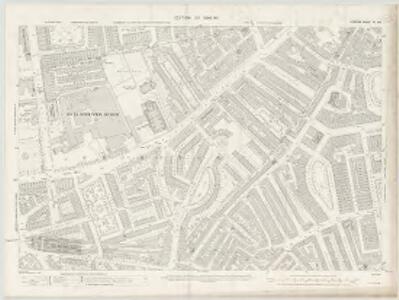
London (1915- Numbered sheets) IV.16 (includes: City Of Westminster; Kensington; Paddington) - 25 Inch Map
1 : 2500 Topographic maps Ordnance Survey Ordnance Survey
London (First Editions c1850s) XLII (includes: City Of Westminster; Kensington; Paddington) - 25 Inch Map
1 : 2500 Topographic maps Ordnance Survey Ordnance Survey
Drawn plan of the Goring Estate] 3
This is a copy by Crace of a plam of the Goring Estate as it was in 1640. The drawing shows the site in Mulberry Garden Fields where Buckingham Palace was built. Crace, Frederick
Plan of Estates IN THE PARISHES OF KENSINGTON AND ST MARGARET'S WESTMINSTER IN THE COUNTY OF MIDDLESEX Purchased by HER MAJESTY'S COMMISSIONERS for the EXHIBITION OF 1851.
1 : 4800 The site in South Kensington depicted in green on this plan was purchased by the Queen's Commissioners to host the Great Exhibition of 1851. The title, key to colours, compass star and scale bar appear down the left side of the plate. The boundaries of the four properties comprising the commissioners' estate are outlined as follows: Gore House in blue, Villar in red, Harrington in yellow and the Smith's Charity Estate in brown. Day & Son
Survey of the District of Hans Town
Drawn survey of the district of Hans Town in Chelsea, with the boundary of the district outlined in red. Indian ink is used to indicate buildings in the Codagan Estate, the rest of the buildings being held by Henry Holland on lease from Codagan.
Plan of Belgrave Square
1 : 1596 This drawn plan also shows adjoining properties in Knightsbridge. Earl Grosvenor was granted permission by Parliament to develop the ten acre site in 1826, and commisioned the young architect George Basevi, a pupil of Sir John Soane, to design the square. Chawner, Thomas
Insurance Plan of London West Vol. A: sheet 10-1
1 : 480 This detailed 1891 plan of London is one of a series of fourteen sheets in an atlas originally produced to aid insurance companies in assessing fire risks. The building footprints, their use (commercial, residential, educational, etc.), the number of floors and the height of the building, as well as construction materials (and thus risk of burning) and special fire hazards (chemicals, kilns, ovens) were documented in order to estimate premiums. Names of individual businesses, property lines, and addresses were also often recorded. Together these maps provide a rich historical shapshot of the commercial activity and urban landscape of towns and cities at the time. The British Library holds a comprehensive collection of fire insurance plans produced by the London-based firm Charles E. Goad Ltd. dating back to 1885. These plans were made for most important towns and cities of the British Isles at the scales of 1:480 (1 inch to 40 feet), as well as many foreign towns at 1:600 (1 inch to 50 feet). Chas E Goad Limited Chas E Goad Limited
Insurance Plan of London Western District Vol. A: sheet 13-3
1 : 480 This detailed 1901 plan of London is one of a series of forty-one sheets in an atlas originally produced to aid insurance companies in assessing fire risks. The building footprints, their use (commercial, residential, educational, etc.), the number of floors and the height of the building, as well as construction materials (and thus risk of burning) and special fire hazards (chemicals, kilns, ovens) were documented in order to estimate premiums. Names of individual businesses, property lines, and addresses were also often recorded. Together these maps provide a rich historical shapshot of the commercial activity and urban landscape of towns and cities at the time. The British Library holds a comprehensive collection of fire insurance plans produced by the London-based firm Charles E. Goad Ltd. dating back to 1885. These plans were made for most important towns and cities of the British Isles at the scales of 1:480 (1 inch to 40 feet), as well as many foreign towns at 1:600 (1 inch to 50 feet). Chas E Goad Limited Chas E Goad Limited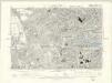
London VI.SE - OS Six-Inch Map
1 : 10560 Topographic maps Ordnance Survey Ordnance Survey
A PLAN of HYDE-PARK with the CITY and LIBERTIES of WESTMINSTER &c. Shewing the several IMPROVEMENTS propos'd
This plan shows renovations in Hyde Park and around Westminster.Two Royal palaces have been planned, in Hyde Park and Green Park. The red lines show an intention to regularize the street plan, replacing the narrow irregular streets with a gridlike formation. Gwynn, John
Charles Booth's descriptive map of London poverty 1889
Charles Booth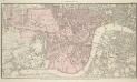
PLAN OF WESTMINSTER. No III
The area shaded red represents the extent of Westminster as defined in the Letters Patent of 3 August 1604. Basire, J.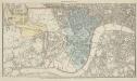
PLAN OF WESTMINSTER. No II
This map is highlighted to give a retrospective view of the extent of Westminster. Represented in blue is the territory of Westminster according to the Decretal of AD1222 , while the red outline shows the present boundary. The green and yellow outlines indicate manor boundaries. Basire, J.
PLAN OF WESTMINSTER. No 1 [A Plan of the City of Westminster, showing all the Parishes, as well as the Ancient Boundary of Westminster, in the year 951.]
An orange coloured area shows the extent of Westminster according to King Edgar's Charter of AD951. The contemporary boundary of Westminster is shown in red. Basire, J.
London SW.
1 : 15840 Stanford, Edward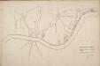
Thames and Metropolis Improvement plan
Martin, John
A PLAN of the ROADS Under the DIRECTION and CARE of this TRUST and divers Roads Adjacent.
1 : 16351 The title of this road map of Kensington and Chelsea appears in a panel above the plan, with the compass star at top right and scale bar at bottom left. The roads within the Kensington and Hyde Park Trust are indicated by a shadowed line; the king's private roads by a double line; the common roads by a double dotted line; and the footpaths by a single dotted line. Turnpikes and junctions are numbered for reference with distances given in a table down the left side of the plate. Roberts, R.
MAP OF THE WESTERN SIDE OF LONDON, DISTINGUISHING THE ESTATE OF HER MAJESTY'S COMMISSIONERS FOR THE EXHIBITION OF 1851.
1 : 21120 Map of Kensington with title along the top and scale bar below the plan. The site of the Great Exhibiton of 1851 in Hyde Park is highlighted in green. Day & Son
CARY's New POCKET PLAN OF LONDON, WESTMINSTER and SOUTHWARK; with all the adjacent buildings in ST. GEORGE'S FIELDS &c.&c.
Pocket plans were made popular by the Bowles companying the 1730s, and had an enduring appeal. This plan, engraved by the prolific John Cary, was published 18 times. This is the first edition. It includes a list of the receiving houses appointed by the General and Penny Post Offices and a table of Hackney coach fares. The postal service in London was largely developed by William Dockwra, who responded to the demand for local letter delivery in London: non-existent until 1680, except by private messenger. Dockwra opened nearly 500 receiving houses where letters were sorted for delivering, costing the user one penny. So successful was this system that it was taken over by the General Post Office after two years. Cary, John
Insurance Plan of London West & West North West Vols. A & B: Key Plan
1 : 10560 This "key plan" indicates coverage of the Goad 1891 series of fire insurance maps of London that were originally produced to aid insurance companies in assessing fire risks. The building footprints, their use (commercial, residential, educational, etc.), the number of floors and the height of the building, as well as construction materials (and thus risk of burning) and special fire hazards (chemicals, kilns, ovens) were documented in order to estimate premiums. Names of individual businesses, property lines, and addresses were also often recorded. Together these maps provide a rich historical shapshot of the commercial activity and urban landscape of towns and cities at the time. The British Library holds a comprehensive collection of fire insurance plans produced by the London-based firm Charles E. Goad Ltd. dating back to 1885. These plans were made for most important towns and cities of the British Isles at the scales of 1:480 (1 inch to 40 feet), as well as many foreign towns at 1:600 (1 inch to 50 feet). Chas E Goad Limited Chas E Goad Limited
The London directory, or a new & improved plan of London, Westminster, & Southwark, with the adjacent country, the new buildings, the new roads, and the late alterations by opening of new streets, & widening of others
1 : 15840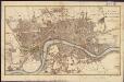
A plan of London, Westminster, and Southwark
1 : 26750