Maps of Camden
London VI.8 - OS London Town Plan
1 : 1056 Topographic maps Ordnance Survey Ordnance Survey
Insurance Plan of London West North-West District Vol. B: sheet 17
1 : 480 This detailed 1902 plan of London is one of a series of eighteen sheets in an atlas originally produced to aid insurance companies in assessing fire risks. The building footprints, their use (commercial, residential, educational, etc.), the number of floors and the height of the building, as well as construction materials (and thus risk of burning) and special fire hazards (chemicals, kilns, ovens) were documented in order to estimate premiums. Names of individual businesses, property lines, and addresses were also often recorded. Together these maps provide a rich historical shapshot of the commercial activity and urban landscape of towns and cities at the time. The British Library holds a comprehensive collection of fire insurance plans produced by the London-based firm Charles E. Goad Ltd. dating back to 1885. These plans were made for most important towns and cities of the British Isles at the scales of 1:480 (1 inch to 40 feet), as well as many foreign towns at 1:600 (1 inch to 50 feet). Chas E Goad Limited Chas E Goad Limited
London (1915- Numbered sheets) IV.3 (includes: Hampstead; Willesden) - 25 Inch Map
1 : 2500 Topographic maps Ordnance Survey Ordnance Survey
London (1915- Numbered sheets) IV.3 (includes: Hampstead; Willesden) - 25 Inch Map
1 : 2500 Topographic maps Ordnance Survey Ordnance Survey
London (1915- Numbered sheets) IV.4 (includes: Hampstead; St Marylebone) - 25 Inch Map
1 : 2500 Topographic maps Ordnance Survey Ordnance Survey
London (1915- Numbered sheets) IV.4 (includes: Hampstead; St Marylebone) - 25 Inch Map
1 : 2500 Topographic maps Ordnance Survey Ordnance Survey
London (First Editions c1850s) XV (includes: Hampstead; St Marylebone) - 25 Inch Map
1 : 2500 Topographic maps Ordnance Survey Ordnance Survey
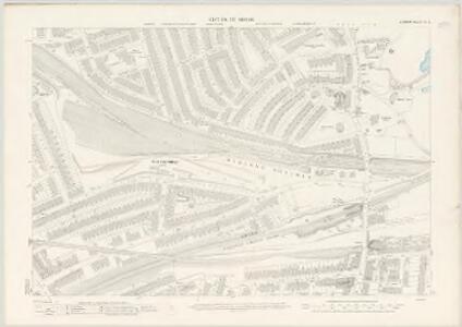
London VI.NE - OS Six-Inch Map
1 : 10560 Topographic maps Ordnance Survey Ordnance Survey
Insurance Plan of London West North-West District Vol. B: Key Plan
1 : 3600 This "key plan" indicates coverage of the Goad 1902 series of fire insurance maps of London that were originally produced to aid insurance companies in assessing fire risks. The building footprints, their use (commercial, residential, educational, etc.), the number of floors and the height of the building, as well as construction materials (and thus risk of burning) and special fire hazards (chemicals, kilns, ovens) were documented in order to estimate premiums. Names of individual businesses, property lines, and addresses were also often recorded. Together these maps provide a rich historical shapshot of the commercial activity and urban landscape of towns and cities at the time. The British Library holds a comprehensive collection of fire insurance plans produced by the London-based firm Charles E. Goad Ltd. dating back to 1885. These plans were made for most important towns and cities of the British Isles at the scales of 1:480 (1 inch to 40 feet), as well as many foreign towns at 1:600 (1 inch to 50 feet). Chas E Goad Limited Chas E Goad Limited
An exact survey of the city's of London Westminster , XII
1 Blatt : 53 x 72 cm John Rocque
London Sheet J - OS Six-Inch Map
1 : 10560 Topographic maps Ordnance Survey Ordnance Survey
London Sheet J - OS Six-Inch Map
1 : 10560 Topographic maps Ordnance Survey Ordnance Survey
Middlesex XVI - OS Six-Inch Map
1 : 10560 Topographic maps Ordnance Survey Ordnance Survey
Map shewing the situation of all premises licensed for the sale of intoxicating liquors in the County of London
London County Council
TQ28 - OS 1:25,000 Provisional Series Map
1 : 25000 Topographic maps Ordnance Survey Ordnance Survey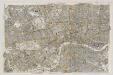
Central London : Recto
1 : 15840 G.W. Bacon & Co G.W. Bacon & Co.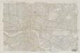
Central London : Verso
1 : 15840 G.W. Bacon & Co G.W. Bacon & Co.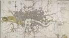
LONDON IN MINIATURE WITH THE Surrounding AN ENTIRE NEW PLAN In which the Improvements both present and intended are actually reduced (by permission) from the surveys of Several Proprietors
The title of this map appears at top right, with scale bar at the bottom centre, and a compass rose near top left. Watercourses, roads and open spaces are depicted in colour. The map shows the proposed new bridges at Waterloo and Vauxhall, extending eastward on an added sheet to include the Isle of Dogs. Mogg, Edward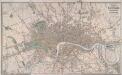
LAURIE'S PLAN OF LONDON, WESTMINSTER AND SOUTHWARK Trigonometrically Surveyed by JOHN OUTHETT
This is a later edition of the folding map first issued by Laurie in 1837. The map features title at top right, key to colours and scale of 40 acres at bottom centre. The border of the map is divided in miles and furlongs from St Paul's Cathedral and seconds of longitude east and west of Greenwich. Laurie, Richard Holmes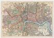
Bacon's map of London : with railways in operation and constructing corrected to date
Bacon & Co Bacon & Co.
Detail from OSD 152 (Hampstead)
1 : 31680 The individual settlements that make up this area of London are shown by red blocks, with boundary lines indicating the fields separating them. Shading and soft interlining indicate relief, neatly illustrated at Primrose Hill, the summit of which is left bare. The barracks at the edge of Hyde Park are illustrated at the very bottom of the map. The dark blue-black line running from West Drayton to Brentford and Paddington is the Grand Junction Canal. This was London's principal link to the rest of Britain's canals, allowing the passage of goods to and from the industrial towns of the North and Midlands. Hyett includes a ground plan of Kenwood House in Hampstead, showing a level of detail much greater than might be expected from a map with a scale of two inches-to-the-mile. Hyett, William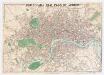
Whitbread's new plan of London
1 : 21500 Whitbread, J J. Whitbread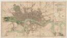
London in miniature : with the surrounding villages, an entire new plan in which the improvements both present and intended are actually reduced (by permission) from the surveys of the several proprietors : the whole laide down from the best authorities
1 : 16000 Mogg, Edward Edward Mogg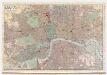
Indicator map of London : with the recent improvements, 1880
C. Smith & Son C. Smith & Son
MOGG'S LONDON AND ITS ENVIRONS Drawn from The latest Surveys
The radius of the red circle on this map (above St. Paul's) extends for three miles around the Post Office. The Post Office was erected on the site of St Martin-le-Grand. Designed by Sir Robert Smirke, it was opened in 1829. Coloured roads represent omnibus routes. Buses gradually replaced hackney coaches after the hackney's monopoly ended in1832. The site of the 1851 Great Exhibition in Hyde Park is indicated. Mogg, E.S.
Map of London : made from an actual survey in the years 1824, 1825, & 1826
1 : 63360 C. & J. Greenwood C. & J. Greenwood
Philip's new plan of London, 1873
1 : 18900 George Philip & Son George Philip & Son
Laurie and Whittle's New map of London with its environs, &c. Including the Recent Improvements.
From Great Britain
London
From Great Britain