Maps of Redbridge
London IV.54 - OS London Town Plan
1 : 1056 Topographic maps Ordnance Survey Ordnance Survey
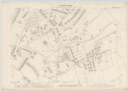
Essex (New Series 1913-) n LXXVIII.10 (includes: Ilford; Leyton; Wanstead) - 25 Inch Map
1 : 2500 Topographic maps Ordnance Survey Ordnance Survey
Essex (New Series 1913-) n LXXVIII.10 (includes: Ilford; Leyton; Wanstead) - 25 Inch Map
1 : 2500 Topographic maps Ordnance Survey Ordnance Survey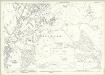
London (Edition of 1894-96) XXIV (includes: Ilford; Leyton; Wanstead) - 25 Inch Map
1 : 2500 Topographic maps Ordnance Survey Ordnance Survey
A Plan of the House, Gardens, Park, and Plantations of Wanstead, the Seat of the Earl of Tylney, by Rocque.
Rocque, John
Essex LXV.SE - OS Six-Inch Map
1 : 10560 Topographic maps Ordnance Survey Ordnance Survey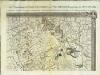
An exact survey of the city's of London Westminster , IV
1 Blatt : 53 x 71 cm John Rocque
London Sheet H - OS Six-Inch Map
1 : 10560 Topographic maps Ordnance Survey Ordnance Survey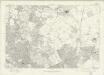
London Sheet H - OS Six-Inch Map
1 : 10560 Topographic maps Ordnance Survey Ordnance Survey
Middlesex XVIII (inset XIII & XXIII) - OS Six-Inch Map
1 : 10560 Topographic maps Ordnance Survey Ordnance Survey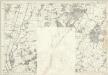
Essex LXV - OS Six-Inch Map
1 : 10560 Topographic maps Ordnance Survey Ordnance Survey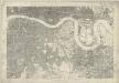
Kent I - OS Six-Inch Map
1 : 10560 Topographic maps Ordnance Survey Ordnance Survey
TQ48 - OS 1:25,000 Provisional Series Map
1 : 25000 Topographic maps Ordnance Survey Ordnance Survey
Stratford - Le - Bow
1 : 21120 This plan of north east London extends from the Isle of Dogs and Wapping at the bottom, to 'Layton Stone' and Epping Forest at the top. Field boundaries infilled with stripes depict tilled land. Major settlements are drawn in red ink. North of Stoke Newington, to the top left, a road is plotted as a series of fixed points pricked off with dividers and joined by ruled pencil lines. These protractions were made directly from the Ordnance Survey field books. Pencil rays intersect across the map, evidence of measurements taken by the surveyor between fixed triangulation points. Poplar Gut is outlined in red at the Isle of Dogs, the beginnings of the development of the West India Docks.
Barking, Essex
1 : 21120 This plan of the north side of the Thames shows Barking and Ilford to the left, on the banks of the Roding, and Rainhham and Hornchurch to the right. A patchwork of field boundaries dominate the landscape, with open dotting depicting unproductive enclosed land. Pencil lines intersect across the plan, recording the angular measurements taken by the surveyor to calculate the distances between fixed points in the landscape.
Plan of the roads and main objects on the eastern part of London : as connected with the tunnel excavating under the Thames from Rotherhithe to Wapping
1 : 48000 Brunel, Marc Isambard, Sir, 1769-1849 H. Teape & Son
Kaart van Londen enz. en van het naby gelegen land ruim een uur gaans rondom dezelve stad : getrokken uit de groote gemeeten kaart van de Hr. John Rocque
1 : 63500 Amstersdam : Isaak Tirion
The fourth sheet of an actual survey of the county of Middlesex in which the parishes within the bills of mortality are bounded with red to be distinguished from the others
1 Blatt : 53 x 70 cm John Rocque
[Recto], uit: Map of general routes / Fred J.H. Elston
1 : 12500 Elston, Fred J. H. London : General Omnibus Co.
England and Wales, Cities, Ports & Harbours.
1 : 63360 Fullarton, A. & Co.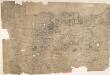
Enfield
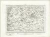
Triangulation lines radiating from fixed points are clearly visible on this map. A pecked red line running adjacent to Lee River marks the boundary separating Essex from Hertforshire and Middlesex. Henhault Forest is shown by a stippled canopy of tree tops at the centre of the drawing. Perhaps the most interesting detail on this map is just south of the forest: a small drawing of a tree inside an enclosure marked 'Fairlop Oak'. This giant oak tree was something of a local landmark. In 1791, William Forsyth, gardener to George III, made unsuccessful attempts to halt the tree's decline. The year that this map was published, the tree was badly burnt by a fire started during a picnic. Its health steadily continued to wane until it was blown down in a gale in 1820. The inclusion of details such as the Fairlop Oak reveals the meticulous nature of the Survey, and the great attention paid to local detail. Budgen, Charles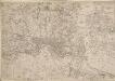
Map of the County of Middlesex in which parishes are bounded with red to be distinguished from the others
The title is missing from this copy of the map. The gives a list of parishes within the Bill of Mortality in scroll at top right with parish boundaries outlined in colour. Land use and reliefs are expressed by symbols, with the built-up area within the City of London represented by stippling. Rocque, John
Ordnance Survey of England. Sheet 257, Romford
1 : 63360 Ordnance survey. GB Southampton : Ordnance Survey Office
Map of London [showing] work of the Metropolitan Public Gardens Association, November, 1882, to December, 1900. Scale of miles, 1 1/2[ = 2 1/4 inches]

A Map of London showing the proportion of the inhabitants of each registration sub-district in 1881, born in other parts of the United Kingdom
Romford (Outline) - OS One-Inch Revised New Series
1 : 63360 Topographic maps Ordnance Survey Ordnance Survey
Romford (Hills) - OS One-Inch Revised New Series
1 : 63360 Topographic maps Ordnance Survey Ordnance Survey
[Recto], uit: L.C.C. trams
1 : 50000 titelvariant: The tramways pocket map & timetable; Annotatie: Omslagtitel: The tramways pocket map & timetable London County Council [London : London County Council]
Stanford's new two inch map of London and its environs
1 : 31680 Londýn (Anglie) Edward Stanford