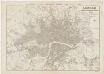
Maps of Hackney
London III.88 - OS London Town Plan
1 : 1056 Topographic maps Ordnance Survey Ordnance Survey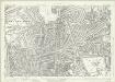
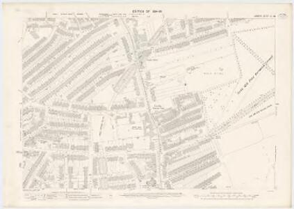
London (1915- Numbered sheets) II.15 (includes: Hackney; Stoke Newington) - 25 Inch Map
1 : 2500 Topographic maps Ordnance Survey Ordnance Survey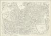
London (1915- Numbered sheets) II.15 (includes: Hackney; Stoke Newington) - 25 Inch Map
1 : 2500 Topographic maps Ordnance Survey Ordnance Survey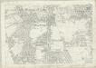
London (First Editions c1850s) X (includes: Hackney; Stoke Newington) - 25 Inch Map
1 : 2500 Topographic maps Ordnance Survey Ordnance Survey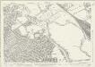
Essex (New Series 1913-) n LXXVII.16 (includes: Hackney; Leyton) - 25 Inch Map
1 : 2500 Topographic maps Ordnance Survey Ordnance Survey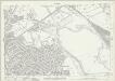
Essex (New Series 1913-) n LXXVII.16 (includes: Hackney; Leyton) - 25 Inch Map
1 : 2500 Topographic maps Ordnance Survey Ordnance Survey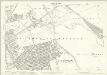
London (Edition of 1894-96) XXXI (includes: Hackney; Leyton) - 25 Inch Map
1 : 2500 Topographic maps Ordnance Survey Ordnance Survey
Insurance Plan of London North & North-East District Vol. E: Key Plan
1 : 21120 This "key plan" indicates coverage of the Goad 1899 series of fire insurance maps of London that were originally produced to aid insurance companies in assessing fire risks. The building footprints, their use (commercial, residential, educational, etc.), the number of floors and the height of the building, as well as construction materials (and thus risk of burning) and special fire hazards (chemicals, kilns, ovens) were documented in order to estimate premiums. Names of individual businesses, property lines, and addresses were also often recorded. Together these maps provide a rich historical shapshot of the commercial activity and urban landscape of towns and cities at the time. The British Library holds a comprehensive collection of fire insurance plans produced by the London-based firm Charles E. Goad Ltd. dating back to 1885. These plans were made for most important towns and cities of the British Isles at the scales of 1:480 (1 inch to 40 feet), as well as many foreign towns at 1:600 (1 inch to 50 feet). Chas E Goad Limited Chas E Goad Limited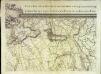
An exact survey of the city's of London Westminster , V
1 Blatt : 53 x 71 cm John Rocque
Essex nLXXVII - OS Six-Inch Map
1 : 10560 Topographic maps Ordnance Survey Ordnance Survey
London Sheet G - OS Six-Inch Map
1 : 10560 Topographic maps Ordnance Survey Ordnance Survey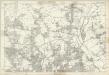
Middlesex XII - OS Six-Inch Map
1 : 10560 Topographic maps Ordnance Survey Ordnance Survey
Plan showing the sewers in Tower Hamlets, 1843
From 1807, the East End was supplied with water pumped from the River Lea at Bow by the East London Waterworks Company. This was not, however, the continuous flow of water we take for granted today. Dr John Simon wrote, in 1849, of the thousands who "wholly depend on their power of attending at some fixed hour of the day, pail in hand, beside the nearest standcock; where, with their neighbours, they wait their turn; sometimes not without a struggle, during the tedious dribbling of a single small pipe. Household rubbish was piled into heaps in the street and outdoor toilets drained into cesspits. The survey of sanitation in Bethnal Green made by Hector Gavin in 1848 paints a sorry picture. Knightly Court was typical of the streets he visited: "In it there are two privies in a beastly state, full, and the contents overflowing into the court. There is one dust reservoir. One stand-tap supplies the seven houses; two cases of severe typhus lately occurred here, one died." This map of 1843 shows the distribution of sewers through the East End. They carried only surface water, contaminated with decayed rubbish from the streets and excrement from overflowing cesspits, and discharged it directly into the Thames - from which water companies pumped their drinking water. James Beek
TQ38 - OS 1:25,000 Provisional Series Map
1 : 25000 Topographic maps Ordnance Survey Ordnance Survey
LAURIE'S NEW PLAN OF LONDON and its ENVIRONS with an Improved Scale FOR ASCERTENING DISTANCES
Map of London and the suburbs with title, imprint and dedication to Lord Viscount Melbourne in table at top right. Below the title, a note explaining that the map was based on the trigonometric survey by General Roy "combined with a new series of 52 stations on elevated situations from which the positions of upward to of 450 steeples, domes, turrets, vanes and other conspicuous objects within the limits of the plan, have been determined by means of more than 5000 angles." Laurie, Richard Holmes
Stratford - Le - Bow
1 : 21120 This plan of north east London extends from the Isle of Dogs and Wapping at the bottom, to 'Layton Stone' and Epping Forest at the top. Field boundaries infilled with stripes depict tilled land. Major settlements are drawn in red ink. North of Stoke Newington, to the top left, a road is plotted as a series of fixed points pricked off with dividers and joined by ruled pencil lines. These protractions were made directly from the Ordnance Survey field books. Pencil rays intersect across the map, evidence of measurements taken by the surveyor between fixed triangulation points. Poplar Gut is outlined in red at the Isle of Dogs, the beginnings of the development of the West India Docks.
NEW PLAN OF LONDON AND THE ENVIRONS from an Original Survey EXTENDING 6 3/4 Miles North & South in which all New and Intended Buildings and Improvements are carefully Inserted
This folding map is set within a decorative border. The title and imprint feature at top right, the compass star at middle right, and scale bar at bottom left. The river, open spaces and the built-up area in the city are delineated in colour. This is the fourth edition of a map first issued by Thompson in 1823, updated with the addition of St. Katherine's Dock and the housing developments in the Marylebone and Mile End areas. Thompson, George
London [11], uit: Geognostische Karte des Oesterreichischen Kaiserstaates mit einem grossen Theile Deutschland's u. Italien / hauptsachlich nach ... Haidinger's geognostischer Karte dieses Staates bearb. von Josef Scheda
1 : 3000000 titelvariant: General-Karte von Europa in 25 Blättern; Annotatie: Bijlage bij: General-Karte von Europa in 25 Blättern. - 1:2.592.000. - 1845-1847 Scheda, Joseph Wien : K.K. Militär. Geografisch. Institut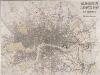
MOGG'S LONDON AND ITS ENVIRONS Drawn from The latest Surveys
The radius of the red circle on this map (above St. Paul's) extends for three miles around the Post Office. The Post Office was erected on the site of St Martin-le-Grand. Designed by Sir Robert Smirke, it was opened in 1829. Coloured roads represent omnibus routes. Buses gradually replaced hackney coaches after the hackney's monopoly ended in1832. The site of the 1851 Great Exhibition in Hyde Park is indicated. Mogg, E.S.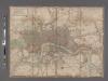
Laurie and Whittle's New map of London with its environs, &c. Including the Recent Improvements.
From Great Britain
London
From Great Britain
A new map of London and its environs : from an original survey extending 8 miles east and west, 6 1/4 miles north & south, in which all new and intended buildings, improvements, &c. are carefully inserted
1 : 17150 Thompson, Mr Reeves & Hoare
LONDON 260
Only the main roads appear on this map, giving the appearance of a rather spacious capital city. The map is covered with a squared grid to allow for the easy calculation of Hackney Cab Fares. New London Bridge is shown without its approaches. Pecked lines show the intended location of the Thames tunnel. East and West India Docks are shown. Rowe, S.
Plan of the roads and main objects on the eastern part of London : as connected with the tunnel excavating under the Thames from Rotherhithe to Wapping
1 : 48000 Brunel, Marc Isambard, Sir, 1769-1849 H. Teape & Son
DAVIES'S MAP OF THE BRITISH METROPOLIS CONTAINING THE BOUNDARIES OF THE BOROUGHS THE RAILWAYS, STATIONS & All MODERN IMPROVEMENTS
This is the second edition of a map published twice in the same year, differing from the first edition only in the publisher's imprint. The development of the railways is evident here. The boroughs and the county-court districts are marked in red capitals. Rees Davis, Benjamin
London : drawn and engraved expressly for the post office directory
1 : 253440 Kelly's Directories Ltd Kelly & Co. Ltd., Post Office Directory Office
CRUCHLEY'S New Plan of LONDON and its ENVIRONS
This map is the 11th edition of Cruchley's 'New Plan'. It was altered on each publication, recording the many developments than spanned this period, particularly railway expansion. In this edition the Waterloo and Bricklayers Arms stations are shown, as are Battersea and Victoria Parks. Prior to the establishment of his own business, Cruchley worked for the Arrowsmiths map-publishing firm. Consequently the words “from Arrowsmiths" appear in his imprint on many of his early maps. George Frederick Cruchley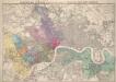
Stanford’s Map of London, shewing the Areas granted to the Electric Light Supply Companies
Edward STANFORD
LONDON Drawn and engraved expressly for the POST OFFICE DIRECTORY
Map of London published by Benjamin Rees Davies for the Post Office Directory with title and scale bar in table at top right. The London post codes W, N, N.E., E, S.E., S and S.W. are indicated. Davies, Benjamin Rees