Cataloged map
Westmorland XLI.NE - OS Six-Inch Map
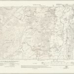

Full title:Westmorland XLI.NE - OS Six-Inch Map
Depicted:1912
Pubdate:1920
Publisher:Ordnance Survey
Physical Size:20 x 30 cm
Map scale:1:10 560
Cumbria [et] Westmoria. vulgo Cumberland [and] Westmorland
1690
Valck; Schenk
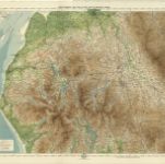
The Lake District, Sheet 3 - Bartholomew's "Half Inch to the Mile Maps" of England & Wales
1903
Bartholomew, John George
1:127k
A new map of the counties of Cumberland and Westmoreland
1760
Tinney; Bowles; Sayer; Bowles; Bowles
Westmoria comitatvs; anglice Westmorland
1646
Blaeu
n/a
1742
Cvmbria; vulgo Cvmberland
1646
Blaeu
n/a
1742
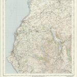
Penrith - OS One-Inch Map
1960
Ordnance Survey
1:63k
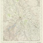
Keswick - OS One-Inch Map
1954
Ordnance Survey
1:63k
Annandiæ præfectura, vulgo the stewartrie of Annandail
1654
Blaeu; Pont