Maps of Manchester
Yorkshire CCXLV.NW - OS Six-Inch Map
1 : 10560 Topographic maps Ordnance Survey Ordnance Survey
Yorkshire CCXLV.NW - OS Six-Inch Map
1 : 10560 Topographic maps Ordnance Survey Ordnance Survey
Yorkshire CCXLV.NW - OS Six-Inch Map
1 : 10560 Topographic maps Ordnance Survey Ordnance Survey
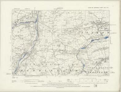
Yorkshire CCXLV.1 (includes: Hebden Royd; Ripponden; Sowerby Bridge) - 25 Inch Map
1 : 2500 Topographic maps Ordnance Survey Ordnance Survey
Yorkshire CCXLV.1 (includes: Hebden Royd; Ripponden; Sowerby Bridge) - 25 Inch Map
1 : 2500 Topographic maps Ordnance Survey Ordnance Survey
Yorkshire CCXLV.5 (includes: Hebden Royd; Ripponden) - 25 Inch Map
1 : 2500 Topographic maps Ordnance Survey Ordnance Survey
Yorkshire CCXLV.5 (includes: Hebden Royd; Ripponden) - 25 Inch Map
1 : 2500 Topographic maps Ordnance Survey Ordnance Survey
Yorkshire CCXLV.6 (includes: Ripponden) - 25 Inch Map
1 : 2500 Topographic maps Ordnance Survey Ordnance Survey
Yorkshire CCXLV.6 (includes: Ripponden) - 25 Inch Map
1 : 2500 Topographic maps Ordnance Survey Ordnance Survey
Yorkshire CCXLV.2 (includes: Hebden Royd; Ripponden; Sowerby Bridge) - 25 Inch Map
1 : 2500 Topographic maps Ordnance Survey Ordnance Survey
Yorkshire CCXLV.2 (includes: Hebden Royd; Ripponden; Sowerby Bridge) - 25 Inch Map
1 : 2500 Topographic maps Ordnance Survey Ordnance Survey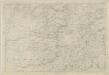
Yorkshire 245 - OS Six-Inch Map
1 : 10560 Topographic maps Ordnance Survey Ordnance Survey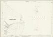
Lancashire LXXXI.8 & 4 (includes: Hebden Royd; Littleborough; Ripponden; Todmorden) - 25 Inch Map
1 : 2500 Topographic maps Ordnance Survey Ordnance Survey
Lancashire LXXXI.8 & 4 (includes: Hebden Royd; Littleborough; Ripponden; Todmorden) - 25 Inch Map
1 : 2500 Topographic maps Ordnance Survey Ordnance Survey
Lancashire LXXXI.4 (includes: Hebden Royd; Littleborough; Ripponden; Todmorden) - 25 Inch Map
1 : 2500 Topographic maps Ordnance Survey Ordnance Survey
SE02 - OS 1:25,000 Provisional Series Map
1 : 25000 Topographic maps Ordnance Survey Ordnance Survey
Lancashire LXXIII.16 (includes: Hebden Royd; Todmorden) - 25 Inch Map
1 : 2500 Topographic maps Ordnance Survey Ordnance Survey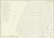
Lancashire LXXIII.16 (includes: Hebden Royd; Todmorden) - 25 Inch Map
1 : 2500 Topographic maps Ordnance Survey Ordnance Survey
Lancashire LXXIII.16 (includes: Hebden Royd; Todmorden) - 25 Inch Map
1 : 2500 Topographic maps Ordnance Survey Ordnance Survey
Lancashire LXXXI.8 & 4 (includes: Hebden Royd; Littleborough; Ripponden; Todmorden) - 25 Inch Map
1 : 2500 Topographic maps Ordnance Survey Ordnance Survey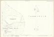
Lancashire LXXXI.8 & 4 (includes: Hebden Royd; Littleborough; Ripponden; Todmorden) - 25 Inch Map
1 : 2500 Topographic maps Ordnance Survey Ordnance Survey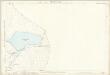
Lancashire LXXXI.8 (includes: Littleborough; Ripponden) - 25 Inch Map
1 : 2500 Topographic maps Ordnance Survey Ordnance Survey
Huddersfield (Hills) - OS One-Inch Revised New Series
1 : 63360 Topographic maps Ordnance Survey Ordnance Survey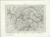
Huddersfield (Outline) - OS One-Inch Revised New Series
1 : 63360 Topographic maps Ordnance Survey Ordnance Survey
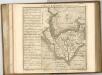
The County of York Survey'd in MDCCLXVII, VIII, IX, and MDCCLXX
London : T. Jefferys
Huddersfield - OS One-Inch Map
1 : 63360 Topographic maps Ordnance Survey Ordnance Survey
Leeds and Bradford - OS One-Inch Map
1 : 63360 Topographic maps Ordnance Survey Ordnance Survey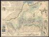
A mineralogical and geological map of the coalfield of Lancashire with parts of Yorkshire, Cheshire & Derbyshire
1 : 90000 Hall, Elias Elias Hall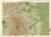
Sheffield, Sheet 9 - Bartholomew's "Half Inch to the Mile Maps" of England & Wales
1 : 126720 Topographic maps Bartholomew, John George John Bartholomew & Co