Maps of Baden-Württemberg
Die Gegenden des Rheins von Speyer biss Mayntz :
Mollova mapová sbírka Homann, Johann Baptist Homann, Johann Baptista - dědici
Die Gegenden des Rheins von Speyer biss Mayntz :
Mollova mapová sbírka Homann, Johann Baptist Homann, Johann Baptista - dědici
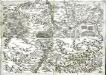
Charte Geographique De la Campagne Du Haut Rhin Pour L'anne MDCCXXXIV
1 : 500000 Mollova mapová sbírka Oettinger, Johann Friedrich Seutter, Matthäus
Charte über das Grossherzogthum Baden
1 : 400000 Bádensko (Německo) Hutter, F. H. C. F. Müller
Charte über das Grossherzogthum Baden
1 : 510000 Bádensko (Německo) Hutter, F.H. C.F. Müller
Charte über das Grossherzogthum Baden
1 : 510000 Bádensko (Německo) Hutter, F. H. C.F. Müller
Charte über das Grossherzogthum Baden
1 : 504000 Bádensko (Německo) Hutter, F.H. C.F. Müller
Charte über das Grossherzogthum Baden
1 : 504000 Bádensko (Německo) Hutter, F. X. C.F. Müller
Charte über das Grossherzogthum Baden
1 : 504000 Bádensko (Německo) Hutter, F. H. C. F. Müller
Charte über das Grossherzogthum Baden
1 : 510000 Bádensko (Německo) Hutter, F. H. C.F. Müller
Charte über das Grossherzogtum Baden / entworfen und revidirt von J.G. Tulla ; die Reduction und Zeichnung von Nachbarstaaten von Krauth ; F.X. Hutter sc.
1 : 500000 Tulla, J. G.; Krauth, ...; Hutter, F. X. Carlsruhe : C.F. Müller
Baden.
1 : 870000 Andree, Richard
Baden.
1 : 870000 Andree, Richard; Times (London, England)
Karte von dem Königreiche Wirtemberg und dem Grosherzogthume Baaden
1 : 787000 Bádensko (Německo)
Karte von dem Grossherzogthum Baden
1 : 400000 Bádensko (Německo) Karten Büreau des Gr. Generalquartiermeisterstabs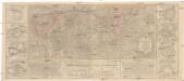
Charte geographique de la campagne de haut Rhin pour l'année 1734 contenant tous les mouvements marches et contremarches des armées imperiales et Francoises
Breisach am Rhein (Německo) Oettinger, Johann Friedrich Matthieu Seutter
Charte des Königreichs Würtemberg und des Grossherzogthums Baadens nebst den angränzenden Ländern
1 : 698000 Bádensko (Německo) Tranquillo Mollo
Straßen im Großherzogtum Baden 1848
Baden Straßennetz Kunz, Andreas ; Treiling, Thomas
Gross Herzogthum Baden
Grosser Hand-Atlas über alle Theile der Erde in 170 Karten Meyer, J. Verlag des Bibliographischen Instituts

Wirtenbergensis Ducatus Vera Descriptio, Tubingae Edita. 1558. [Karte], in: Theatrum orbis terrarum, S. 75.
1 Karte aus Atlas Ortelius, Abraham
Carte des Rein Stroms
Basilej (Švýcarsko)
Karte vom Königreich Wirtemberg nebst dem Fürstenthum Hohenzollern-Sigmaringen und Sigmaringen
1 : 440000 Sigmaringen (Německo) Walch, Johann Joh. Walch
Karte vom Königreich Wirtemberg nebst dem Fürstenthum Hohenzollern-Sigmaringen
1 : 440000 Württembersko (Německo) Walch, Johann Joh. Walch
Ducatus Wurtenbergensis
1 Karte : Kupferdruck ; 54 x 46 cm Visscher; Schenk; Gouwen nunc apud Pet: Schenk iun
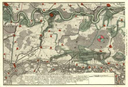
General Idèe Du Terrain qu'ont occupé nos Troupes tant dans la foret noire que le Long de L'inondation et du Rhin. La Campagne. 1735
Geographica provinciarum Sueviae descriptio, 1
4 Blätter : Johann Georg Bodenehr
Ducatus Würtenbergici
1 Karte : Kupferdruck ; 47 x 58 cm Majer; Schenk Pieter Schenk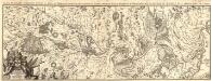
Carte de Quelques Fortresses situees au Bord du Rhin dans la quelle sont compris les Lignes Imperes de Buhl, de Hagenau et de Weissenburg, avec la Bataille de Hunningue, et le dernièr Siège de Landau
1 : 180000 Mollova mapová sbírka Fuchs, Johann Konrad Wolff, Jeremias