Maps of Niedersachsen

Rhenus
1 : 330000 Mollova mapová sbírka Michal, Jacques de Seutter, Matthäus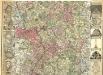
Rhenus per tres Tabellas delineatus
1 : 330000 Mollova mapová sbírka Michal, Jacques de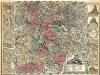
Rhenus per tres Tabellas delineatus
1 : 330000 Mollova mapová sbírka Michal, Jacques de
Rhenus per tres Tabellas delineatus
1 : 330000 Mollova mapová sbírka Michal, Jacques de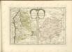
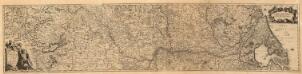
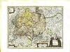
Totius Rheni â fontibus usque ad Ostia Novissima Descriptio
1 : 530000 Mollova mapová sbírka Bodenehr, Johann Georg Neureutter, Augustin
Totius FLUMINIS RHENI Novissima DESCRIPTIO
1 : 910000 Nizozemsko Visscher, Nicolaes Jansz. ex officina N. Visscher
Westdeutsches Mittelgebirge
Plastischer Schul-Atlas über alle Theile der Erde : in 24 Karten Woldermann, G Verlag von P. Eckerlein
Composite: Sud-West Deutschland, Schweiz.
1 : 925000 Vogel, C.
Baden.
1 : 670000 Flemming, Carl
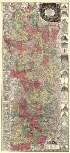
Karte von Frankreich in XVI Blättern, No. 4 und [No. 8]
2 Blätter : 53 x 34 cm Königl. Preuss. Academischen Kunst und Buchhandlung
Schematische Uebersichts - Skizze No,1 Feldzug 1796 in Süd - Deutschland

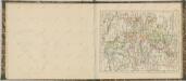
Totius Fluminis Rheni Novissima Descriptio [Karte, Teil 1], in: Novus atlas absolutissimus, Bd. 2, S. 150.
1 Karte aus Atlas Janssonius Offizin
Westdeutschland
Volksschul-Atlas über alle Teile der Erde Lange, Henry Druck und Verlag von Georg Westermann
Teatre De La Guerre sur le Rhein, Moessele, Mayn, &c le Necker [Karte], in: Atlas nouveau, contenant toutes les parties du monde [...], Bd. 1, S. 229.
1 Karte aus Atlas Sanson, Nicolas Jaillot, Alexis Hubert und Mortier, Pieter
Rhenish Prussia, Westphalia, Hesse-Nassau, Waldeck, Lippe, Hesse.
1 : 1000000 Andree, Richard; Times (London, England)
Haut, Bas Rhin.
1 : 640000 Robert de Vaugondy, Gilles, 1688-1766
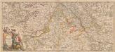
Grand Theatre de la Guerre sur les Frontieres de France & d'Allemagne
1 : 240000 Mollova mapová sbírka Delisle, Guillaume Ottens, Josua
Rheinprovinz, Westfalen, Hessen-Nassau, Waldeck, Grossherzogthum Hessen.
1 : 1000000 Andree, Richard
[Southwest Germany]
1 : 1400000 [S.l. : s.n.]
Charte von den Königlich Preussischen Provinzen Westphalen Cleve-Berg und Niederrhein dem Kurfürstenthume Hessen, Grossherzogthume Hessen, dem Herzogth. Nassau Fürstenth. Waldeck und dem Gebiete der freien Stadt Frankfurt
1 : 800000 entworfen von C. F. Weiland Weimar : im Verlage des Geograph. Instituts
Totius fluminis Rheni novissima descriptio
Rýn, řeka-oblast Wit, Frederick de Frederick de Witt
Le Cercle Eslectorial Du Rhein subdivié entous les Estats qui le composent [Karte], in: Atlas nouveau, contenant toutes les parties du monde [...], Bd. 1, S. 290.
1 Karte aus Atlas Sanson, Nicolas Jaillot, Alexis Hubert und Mortier, Pieter
Geognostische Karte von Württemberg, Baden und Hohenzollern
1 : 700000 Bach, Carl Philipp Heinrich Verlag der G. Ebner'schen Kunsthandlung
Westphalen, Rhein-Privinz, Hessen.
1 : 700000 Weiland, C. F. (Carl Ferdinand), d. 1847
Geographisch-statistische Post- und Resekarte zu den besuchtesten Rhein- und Main-Gegenden
1 : 831500 Mohan (Německo) Bauerkeller, Georg J.P. Streng
Die königlich preussische Provinz Westphalen und die Rhein-Provinz, uit: General Charte von dem Koenigreiche Sachsen / nach den besten vorhandenen Hilfsmitteln und nach den neuesten äussern und innern Begränzungen des Königreichs entworfen von C.F. Weiland
1 : 300000 titelvariant: Royaume de Saxe, Pays de Saxe, Provinces du Rhin et Hesse Cassel & Darmstadt; Annotatie: In hoesje met opdruk: Royaume de Saxe, Pays de Saxe, Provinces du Rhin et Hesse Cassel & Darmstadt Weiland, C. F. Weimar : im Verlage des Geographischen Instituts