Maps of Schwalm-Eder-Kreis

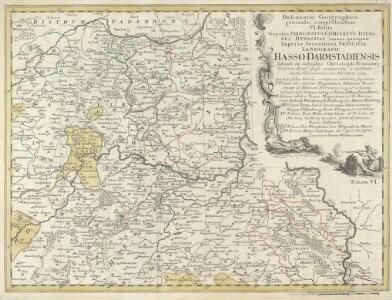
Delineatio Geographica generalis comprehendens VI. Foliis Singulos Principatvs Comitatvs Ditiones Dynastias omnes quotquot Imperio Serenissimi Principis Landgrafii Hasso-Darmstadiensis subsunt :
1 : 180000 Mollova mapová sbírka Bronner, Christian Maximilian Homann, Johann Baptista - dědici
[Fritzlar] / hrsg. von der kgl. geologischen Landesanstalt in Berlin ; geognostisch bearb. von F. Beyschlag ... [et al.] 1888-1889
1 : 80000 Annotatie geografische gegevens: Legenda rechts van de kaart Franz Heinrich August Beyschlag 1856-1915; Kgl. geologische Landesanstalt, Berlin [Berlin : Verlag der Simon Schropp'schen Hof-Landkartenhandlung (J.H. Neumann)]

Landgraviatus Hassiae Inferioris Comitatvs Waldeciae Eichsfeldiae Tabvla Geographica
1 : 140000 Mollova mapová sbírka Berger, Daniel
111. Arolsen, uit: Topographische Uebersichtskarte des Deutschen Reiches / herausgegeben v. d. Kartogr. Abt. d. Königl. Preuß. Landesaufnahme
1 : 200000 titelvariant: Topogr. Übersichtskarte des Deutschen Reiches; Annotatie: Titel boven bladen ook: Topogr. Übersichtskarte des Deutschen Reiches; Annotatie geografische gegevens: Op elk blad twee maatstokken: 10 Kilometer = 5,5 cm; 1 geogr. Meile = 3,6 cm; Legenda onder op elk blad Königlich Preußische Landesaufnahme. Kartographische Abtheilung [S.l : Königlich Preußische Landesaufnahme, Kartographische Abtheilung]
Waldecciae ac Finitimorum Dominiorum Itterani & Casteiniani nec non infertae Dioeceses Eimelrodensis accurata Tabula excusa
1 : 110000 Mollova mapová sbírka Homann, Johann Baptist Homann, Johann Baptista - dědici
Waldeccensis comitatvs descriptio accvratissima
1 Karte : Kupferdruck ; 31 x 21 cm Moers; Ortelius s.n.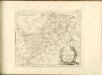

Plan du Siege de Cassel, avec les Travaux et les Tranchées des Alliés devant cette Place
1 : 20000 Mollova mapová sbírka Gerlach, H. D. Schley, Jacobus van der Gosse, Pierre II.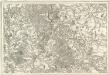
Tableau Topographique Qui comprend la Partie Septentrionale du Landgraviat de Hesse Cassel et de la Principauté de Waldeck, l'Eveché de Paderborn, Partie du Comté de Grubenhague et les Frontieres de ces Etats]
1 : 130000 Mollova mapová sbírka Julien, Roch-Joseph Julien, Roch Joseph
Plan de la Bataille de Wilhelmsthal
1 : 55000 Mollova mapová sbírka Bauer, Friedrich Wilhelm von Schley, Jacobus van der Gosse, Pierre II.
TERRITORIVM | ABBATIÆ HERESFEL- | DENSIS. | 't Stift | Hirszfeldt.
Apud Guiljelmum Blaeu.
Plan du siege de Cassel, avec les travaux et les tranchées des alliés devant cette place, commande par S. A. S. Monseigneur Le Prince Frederic Auguste Duc de Brunswic et de Luneburg, ... depuis le 18. d'Aout jusqu'au 1. Novembre 1762 où la place se [...]
1 : 22000 ... levé par H.D. Gerlach lieutenant du Genie gravé sous la direction de J. v. Schley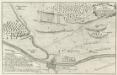
Plan der Action welche zwischen denen Französischen und Hessischen Trouppen d: 23 Jul: 1758 ohnweit Cassel bey Hof- Ellenbach vorgefallen
Mollova mapová sbírka
Uebersicht der nicht geschlossenen Gewässer des Regierungsbezirks Cassel und deren Schonzeiten
Kassel (Německo) Wenderoth, Georg
Meßtischblatt 2922, neue Nr. 5021 : Ziegenhain, 1937
1 : 250000 Ziegenhain. - Hrsg. 1908, einz. Nachtr. 1937. - 1:25000. - [Berlin]: Reichsamt für Landesaufnahme, 1937. - 1 Kt.
Meßtischblatt 2921, neue Nr. 5020 : Gilserberg, 1937
1 : 250000 Gilserberg. - Hrsg. 1908, einz. Nachtr. 1937. - 1:25000. - [Berlin]: Reichsamt für Landesaufnahme, 1937. - 1 Kt.
Meßtischblatt 2920, neue Nr. 5019 : Gemünden i. Hessen-Nassau, 1937
1 : 250000 Gemünden i. Hessen-Nassau. - Hrsg. 1908, einz. Nachtr. 1937. - 1:25000. - [Berlin]: Reichsamt für Landesaufnahme, 1937. - 1 Kt.
Meßtischblatt 2793 : Bad Wildungen, 1934
1 : 250000 Bad Wildungen. - Hrsg. 1908, einz. Nachtr. 1934. - 1:25000. - [Berlin]: Reichsamt für Landesaufnahme, 1934. - 1 Kt.
Meßtischblatt 2732 : Waldeck, 1914
1 : 250000 Waldeck. - Aufn. 1906, hrsg. 1908, Aufl.-dr. 1914. - 1:25000. - [Berlin]: Reichsamt für Landesaufnahme, 1914. - 1 Kt.
Meßtischblatt 2731 : Korbach, 1936
1 : 250000 Korbach. - Hrsg. 1908, einz. Nachtr. 1924, gedr. [19]36. - 1:25000. - [Berlin]: Reichsamt für Landesaufnahme, 1936. - 1 Kt.
Meßtischblatt 2665 : Kassel (Ost), 1927
1 : 250000 Kassel (Ost). - Hrsg. 1909, einz. Nachtr. 1927. - 1:25000. - [Berlin]: Reichsamt für Landesaufnahme, 1927. - 1 Kt.
Meßtischblatt 2665 : Cassel (Ost), 1909
1 : 250000 Cassel (Ost). - Aufn. 1907. - 1:25000. - [Berlin]: Reichsamt für Landesaufnahme, 1909. - 1 Kt.
Meßtischblatt 2664 : Cassel (West), 1909
1 : 250000 Cassel (West). - Aufn. 1907. - 1:25000. - [Berlin]: Reichsamt für Landesaufnahme, 1909. - 1 Kt.
Meßtischblatt 2663 : Wolfhagen, 1908
1 : 250000 Wolfhagen. - Aufn. 1906. - 1:25000. - [Berlin]: Reichsamt für Landesaufnahme, 1908. - 1 Kt.
Meßtischblatt 2662 : Arolsen, 1933
1 : 250000 Arolsen. - Aufn. 1906, einz. Nachtr. 1926. - 1:25000. - [Berlin]: Reichsamt für Landesaufnahme, [19]33. - 1 Kt.
Meßtischblatt 2662 : Arolsen, 1908
1 : 250000 Arolsen. - Aufn. 1906. - 1:25000. - [Berlin]: Reichsamt für Landesaufnahme, 1908. - 1 Kt.
Meßtischblatt 2661 : Mengeringhausen, 1932
1 : 250000 Mengeringhausen. - Hrsg. 1908, einz. Nachtr. 1926. - 1:25000. - [Berlin]: Reichsamt für Landesaufnahme, [19]32. - 1 Kt.