Maps of Bavaria

Chur-Bairn Samt demselben incorporirten und angrenzenden Landen
1 : 730000 Mollova mapová sbírka Riegel, Christoph Riegel, Christoph
Bavaria.
1 : 660000 Robert Laurie & James Whittle
Bayern
1 Karte : Kupferdruck ; 41 x 41 cm Sanson; Cordier chez l'autheur
Circulus Bavaricus
1 Karte : Kupferdruck ; 56 x 48 cm Valck; Valck Valck
Bavaria.
1 : 1650000 Bowen, Frances
Geographische Mauth=Charte von Baÿern
1 Karte : Kupferdruck ; 55 x 65 cm Kohlbrenner; Lotter s.n.
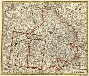
Circulus Bavaricus, in qua Archiep. Saltzburgi, Episc. Ratisbonae, Passaviae et Freisingiae. Praep. Bergtolsgadiae. Ducat. Superior. et Inferior. Bavariae, et Neoburgi; Comitat. Palatinus. et Landgrav. Luchtenbergae.
1 : 675000 Mollova mapová sbírka Valk, Gerhard Valck, Gerard
Carte du duché et electorat de Baviere
1 Karte : Kupferdruck ; 40 x 46 cm Brion de la Tour; Chambon; Esnault; Rapilly chez Esnauts et Rapilly rue S. Jacques a la ville de Coutances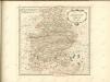

Le cercle de Baviere
1 Karte : Kupferdruck ; 59 x 44 cm Jaillot; Ottens; Ottens chez R. et J. Ottens
Le cercle de Baviere
1 Karte : Kupferdruck ; 59 x 44 cm Drogenham; Jaillot chez H. Jaillot
Teutschlandes Bayerischer Creiss samt dazu gehörigen Provintzen
1 : 2500000 Mollova mapová sbírka Weigel, Johann Christoph Weigel, Christoph I.
Charte des Bayrischen Kreises
1 Karte : Kupferdruck ; 55 x 44 cm Schmidburg; Zach; Amman; Cassini de Thury; David; Humboldt im Verlage des privil. Landes-Industrie-Compt
Boioaria aetate romanorvm collata cvm hodierna
1 Karte : Kupferdruck ; 24 x 29 cm Braun; Zimmermann Ruprecht
Chur=Baiern
1 Karte : Kupferdruck ; 46 x 55 cm Riegel zu finden bey Christoph Riegel
CHARTE vom KÖNIGREICHE BAYERN
Bavorsko (Německo)
1:500,000 Europe (Air) G.S.G.S. No. 4072, Munchen
Sheet NE48-10 from the map series: 1:500,000 Europe (Air) G.S.G.S. No. 4072.

Novissima et Accuratissima Delineatio Geographica Superioris et inferioris Ducatus Bavariae Vnacum adjecentium Provinciarum Limitibus
1 : 750000 Mollova mapová sbírka Sedelmayer, Johann Paul Sedlmayr, Johann Paul
Geschäfts-Uebersichtskarte des Steuer-Katasters bis zum Schlusse des Jahres 18..
1 : 800000 K. Stiglmayer Contur gravirt J. Obernetter Schrift gravirt [S.l.] : [s.n.]
Cours du Danube
1 : 660000 Bavorsko (Německo) Homann, Johann Baptist Le Rouge, Georges-Louis le Rouge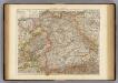
Wurtemberg, Bavaria.
1 : 1000000 Andree, Richard; Times (London, England)
Der bayerische Kreis
1 Karte : Kupferdruck ; 29 x 25 cm Sotzmann; Schmidt s.n.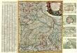
Neue und vollständige Land-Karten Des gantzen Chür-Baÿrischen Reichs Creÿses in specie Das Hertzogthüm Baÿern, die Obere Pfaltz, das Ertz-Stifft Saltzbürg, die Büsthümer Freising und Passaü wie äuch einen mercklichen Theil des daran stoßenden Franckens, Böhmens ünd Ober Oesterreichs vorstellend in dere[n] noch flienere inländische Gräntzen, Stationen deren Posten ünd anderen Nothwendigkeite aüf das genaüeste eingetheilet aüch mit großer Mühe und Fleiß an das Licht gebracht
1 : 650000 Mollova mapová sbírka Lidl, Johann Jakob Lidl, Johann Jacob
Karte vom Königreich Baiern
1 : 1100000 Bavorsko (Německo) in A.G. Schneider u. Weigels k. priv. Kunst- u. Landkartenhandlung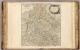
Cercle de Baviere.
1 : 640000 Robert de Vaugondy, Gilles, 1688-1766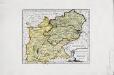
Das Herzogthum Ober und Nieder Bayern
1 Karte : Kupferdruck ; 22 x 27 cm Reilly F. J. J. von Reilly
Circulus Bavaricus in quo sunt ducatus electoratus et palatinatus Bavariae, Neoburgi archiepiscopatus Salisburgi etc
1 : 760000 Bavorsko (Německo) Danckerts, Justus per Iustinum Danckerum
Circulus Bavaricus
1 Karte : Kupferdruck ; 49 x 57 cm Danckerts Danckerts