Maps of Bad Wurzach
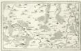
Wolfeck, Wurtzach, Zeyl a okolí]
Mollova mapová sbírka Bodenehr, Gabriel Bodenehr, Gabriel
Meßtischblatt [8025] : Wurzach, 1920
1 : 250000 Wurzach. - 1:25000. - Stuttgart, 1920. - 1 Kt.
Plan zur vierten und fuenften Kriegs-Uebung im Jahr 1846
1 : 25000
Meßtischblatt [8026] : Aitrach, 1921
1 : 250000 Aitrach. - 1:25000. - Stuttgart, 1921. - 1 Kt.
Meßtischblatt [8024] : Waldsee, 1914
1 : 250000 Waldsee. - 1:25000. - Stuttgart, 1914. - 1 Kt.
Meßtischblatt [8125] : Diepoldshofen, 1920
1 : 250000 Diepoldshofen. - 1:25000. - Stuttgart, 1920. - 1 Kt.
Meßtischblatt [8126] : Leutkirch, 1921
1 : 250000 Leutkirch. - 1:25000. - Stuttgart, 1921. - 1 Kt.
Meßtischblatt [8124] : Reute, 1913
1 : 250000 Reute. - 1:25000. - Stuttgart, 1913. - 1 Kt.
Plan zur dritten Kriegs-Uebung im Jahr 1846
1 : 25000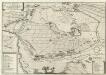
Obsidivm Memmingiae 1647
Mollova mapová sbírka Merian, Matthaeus Merian, Matthäus - dědici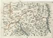
Geographica Provinciarum Sveviae Descriptio =
Mollova mapová sbírka Hurter, Johann Christoph Bodenehr, Gabriel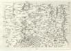
Geographica Provinciarum Sveviae Descriptio =
Mollova mapová sbírka Hurter, Johann Christoph Bodenehr, Johann Georg
187. Lindau, uit: Topographische Uebersichtskarte des Deutschen Reiches / herausgegeben v. d. Kartogr. Abt. d. Königl. Preuß. Landesaufnahme
1 : 200000 titelvariant: Topogr. Übersichtskarte des Deutschen Reiches; Annotatie: Titel boven bladen ook: Topogr. Übersichtskarte des Deutschen Reiches; Annotatie geografische gegevens: Op elk blad twee maatstokken: 10 Kilometer = 5,5 cm; 1 geogr. Meile = 3,6 cm; Legenda onder op elk blad Königlich Preußische Landesaufnahme. Kartographische Abtheilung [S.l : Königlich Preußische Landesaufnahme, Kartographische Abtheilung]
Die Lande der Reichs=Erb=Truchsessen zu Waldburg
1 Karte : Kupferdruck ; 22 x 24 cm Reilly F. J. J. von Reilly
Constanz - Lindau
1 : 200000 Herder, Benjamin
Suevia Universa :
1 : 170000 Mollova mapová sbírka Michal, Jacques de Seutter, Matthäus Seutter, Matthäus
Constanz - Lindau : Ulm
Woerl, Joseph Edmund Herder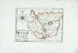
Die gefürstete Abtey Kempten
1 Karte : Kupferdruck ; 19 x 27 cm Reilly F. J. J. von Reilly
Suevia Universa :
1 : 170000 Mollova mapová sbírka Michal, Jacques de Seutter, Matthäus Seutter, Matthäus
Die Lande der Grafen Fugger
1 Karte : Kupferdruck ; 20 x 25 cm Reilly F. J. J. von Reilly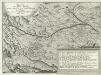
Grundriß des Ihler Flusses
Mollova mapová sbírka Esser, Johann Georg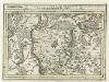
Territorium der des H. R. R. Statt Memmingen samt denen angräntzenden Herrschafften.
1 : 2800 Mollova mapová sbírka Bodenehr, Gabriel Bodenehr, Gabriel
Ulm 142, uit: [W. Liebenow's Special-Karte von Mittel-Europa]
1 : 300000 titelvariant: W. Liebenow's Mittel-Europa; Annotatie: Titel boven de bladen: W. Liebenow's Mittel-Europa Johannes Wilhelm Liebenow 1822-1897 Hannover : Hermann Oppermann
Ulm 142, uit: Special-Karte von Mittel-Europa / nach amtlichen Quellen bearbeitet von W. Liebenow
1 : 300000 titelvariant: W. Liebenow's Mittel-Europa; Annotatie: Titel boven de bladen: W. Liebenow's Mittel-Europa Johannes Wilhelm Liebenow 1822-1897 Frankfurt a. M. : Ludwig Ravenstein
Suevia universa IX. tabulis delineata, 5
1 Blatt : s.n.
Le Theatre de Bellone :
Mollova mapová sbírka Schenk, Pieter Braakman, Adriaan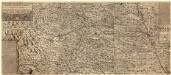
Ilerae Amnis ac Vtrinqve adiacentis Alemanniae Geographica descriptio
1 : 120000 Mollova mapová sbírka Hurter, Johann Christoph Custos, Raphael Hurter, Christoph
Lacus Constan. XX. Tab. Nova. [Karte], in: Geographia universalis vetus et nova complectens Claudii Ptolemaei Alexandrini enarrationis libros VIII, S. 356.
1 Karte aus Atlas Münster, Sebastian [und Ptolemaeus, Claudius]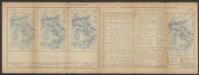
Lacus Constan. XX. Tab. Nova. [Karte], in: Claud. Ptolemaeus. Geographia lat. cum mappis [...], S. 416.
1 Karte aus Atlas Münster, Sebastian [und Ptolemaeus, Claudius]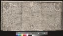
![Wolfeck, Wurtzach, Zeyl a okolí]](https://images-2.georeferencer.com/images/iiif/831964193634/full/,300/0/native.jpg)

