Maps of Grand Est

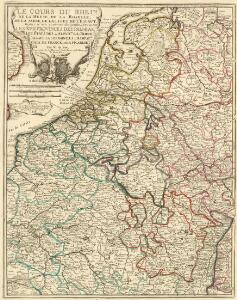
Le Cours du Rhein
1 : 1100000 Mollova mapová sbírka Fer, Nicolas de Fer, Nicolas de
The Spanish Netherlands.
from A system of geography, or, A new & accurate description of the earth in all its empires, kingdoms and states : illustrated with history and topography, and maps of every country : fairly engraven on copper, according to the latest discoveries and corrections / by Herman Moll.
Kriegsschauplatz oder Graenzkarte zwischen Deutschland und Franckreich
1 Karte auf 2 Blättern : Kupferdruck ; 61 x 56 cm Walch zu haben bei Ioh. Walch im eignem Kunstverlag
Carte des peuples riverains du Rhin au temps d’Auguste et de ses successeurs immédiats
Mitteleuropa Rhein-Gebiet ethnische Gruppe Germanen
Germaniae Cisrhenanae ut inter J. Caesaris et Trajani fuit imperia Scaldis item Mosae ac Rheni Ostiorum Antiqua descriptio.
1 : 2500000 [S.l.] : [s.n.]
Unsere Westgrenze
1 : 1000000 Evropa západní Velhagen & Klasing
D.O.M. Carte Generale Des Dixsept Provinces des Pays-Bas avec les Frontieres de France, d'Allemagne et Partie de l'Angleterre Nouvellement dreßée sur plusieur Momoires tirés sur les Lieux pendant les Guerres
1 : 750000 Mollova mapová sbírka Sengre, Henri Misson, François Maximilien
Map Western Front.
1 : 633600 C.S. Hammond & Company
[Kaart], uit: Kaart der bevaarbare waterloopen van België, Nederland, N.-Frankrijk, W.-Duitschland, en den Rijn van Rotterdam tot Basel = Carte des voies navigables de la Belgique, la Hollande, N. de la France, Allemagne Est, et le Rhin de Rotterdam à Bâle = Wasserstrassen Karte von Belgien, Holland, N. Frankreich, W. Deutschland und der Rhein von Rotterdam bis Basel
1 : 800000 Antwerpen : Seghers
Descriptio Germaniae Inferioris. [Karte], in: Theatrum orbis terrarum, S. 162.
1 Karte aus Atlas Ortelius, Abraham Vrients, Jan Baptista
Theatrum Belli Serenissimae Domus Austriacae
1 : 410000 Mollova mapová sbírka Oettinger, Johann Friedrich Seutter, Matthäus
Theatrum Belli Serenissimae Domus Austriacae
1 : 410000 Mollova mapová sbírka Oettinger, Johann Friedrich Seutter, Matthäus
Theatrum Belli Serenissimae Domus Austriacae
1 : 410000 Mollova mapová sbírka Oettinger, Johann Friedrich Seutter, Matthäus
Theatrum Belli Serenissimae Domus Austriacae
1 : 410000 Mollova mapová sbírka Oettinger, Johann Friedrich Seutter, Matthäus
Theatrum Belli Serenissimae Domus Austriacae
1 : 410000 Mollova mapová sbírka Oettinger, Johann Friedrich Seutter, Matthäus
Theatrum Belli Serenissimae Domus Austriacae
1 : 410000 Mollova mapová sbírka Oettinger, Johann Friedrich Seutter, Matthäus
Bojište [sic] 1870
Belgie Bedřich Sandtner
Europe Centrale (Partie Occidentale).
1 : 1750000 Jouvet et Cie.
[Recto], uit: Descriptio Germaniae Inferioris
1 : 1000000 Annotatie: Waarschijnlijk gegraveerd door F. Hogenberg; Uit: Theatrum Orbis Terrarm. - Antwerpen, 1570 Hogenberg, Franz [Antwerpen : Abraham Ortelius]
Descriptio Germaniae Inferioris. [Karte], in: Theatrum orbis terrarum, S. 42.
1 Karte aus Atlas Ortelius, Abraham
Leo Belgicus / Johan van Doetechum fecit
1 : 350000 Annotatie: Facs. van de uitg.: [Amsterdam] : C.J. Visscher excudit, 1650. - Het betreft de 3e staat van de kaart van J. van Doetechum uit 1598, bijgewerkt door C.J. Visscher; Uitg. t.g.v. de tentoonstelling "De wereld op papier", in het Amsterdams Historisch Museum, april 1967 Joannes van Doetecum de Oudere -1605; Visscher, Claes Jansz. [S.l. : s.n.]
Les Provinces Apellées Pais Bas Connues Sous Les Noms De Flandre Et De Hollande
1 : 600000 Mollova mapová sbírka Fer, Nicolas de Loon, Herman van Fer, Nicolas de
[Königreich der Niederlande]
Neuester Schul-Atlas Walch, Johann im Verlag bei Joh. Walch
Belli ab obitu Caroli VI. Imperatoris usqve ad pacem Dresdae d. 25. Dec. MDCCXLV
1 : 1300000 Mollova mapová sbírka Kraus, Lorenz Jacob Homann, Johann Baptista - dědici
Carte du Royaume des Pays-Bas, comprenant les routes de poste et relais depuis Paris jusqu'aux frontières septentrionales de la Hollande, avec un Itinéraire des communications de Strasbourg à Amsterdam et Hambourg
1 : 1280000 [par] Hocquart. Paris : Audin
Royaume des Pays-Bas. Europe 13.
1 : 1641836 Vandermaelen, Philippe, 1795-1869
Le royaume de France, 2
1 Blatt : 60 x 43 cm Jaillot
France

Belgivm sive Inferior Germania
1 : 1500000 Mollova mapová sbírka Weigel, Christoph Goos, Abraham Weigel, Christoph I.