Maps of Welver

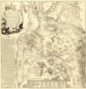
Plan de la Bataille de Vellingshausen
1 : 40000 Mollova mapová sbírka Bauer, Friedrich Wilhelm von Schley, Jacobus van der Gosse, Pierre
Meßtischblatt 2435 : Rhynern, 1934
1 : 250000 Rhynern. - Hrsg. 1897, einz. Nachtr. 1927, gedr. [19]34. - 1:25000. - [Berlin]: Reichsamt für Landesaufnahme, 1934. - 1 Kt.
Meßtischblatt 2508 : Werl, 1927
1 : 250000 Werl. - Hrsg. 1897, einz. Nachtr. 1927. - 1:25000. - [Berlin]: Reichsamt für Landesaufnahme, 1927. - 1 Kt.
Meßtischblatt 2508 : Werl, 1897
1 : 250000 Werl. - Aufn. 1895. - 1:25000. - [Berlin]: Reichsamt für Landesaufnahme, 1897. - 1 Kt.
Meßtischblatt 2436 : Herzfeld in Westfalen, 1934
1 : 250000 Herzfeld in Westfalen. - Aufn. 1895, einz. Nachtr. 1927, gedr. [19]34. - 1:25000. - [Berlin]: Reichsamt für Landesaufnahme, 1934. - 1 Kt.
Meßtischblatt 2436 : Herzfeld in Westfalen, 1910
1 : 250000 Herzfeld in Westfalen. - Aufn. 1895, hrsg. 1897, einz. Nachtr. 1910. - 1:25000. - [Berlin]: Reichsamt für Landesaufnahme, 1910. - 1 Kt.
Meßtischblatt 2509 : Soest, 1927
1 : 250000 Soest. - Hrsg. 1897, einz. Nachtr. 1927. - 1:25000. - [Berlin]: Reichsamt für Landesaufnahme, 1927. - 1 Kt.
Meßtischblatt 2509 : Soest, 1897
1 : 250000 Soest. - Aufn. 1895. - 1:25000. - [Berlin]: Reichsamt für Landesaufnahme, 1897. - 1 Kt.
Übersichts Karte für den Marsch der Aliirten Armee, begonnen in der Nacht vom 1ten auf den 2ten Juli, beendet am 4ten Juli 1761
1 : 86400
Meßtischblatt 2434 : Hamm, 1914
1 : 250000 Hamm. - Aufn. 1892, hrsg. 1894, Aufl.-dr. 1914. - 1:25000. - [Berlin]: Reichsamt für Landesaufnahme, 1914. - 1 Kt.
97. Münster i/Wf., uit: Topographische Uebersichtskarte des Deutschen Reiches / herausgegeben v. d. Kartogr. Abt. d. Königl. Preuß. Landesaufnahme
1 : 200000 titelvariant: Topogr. Übersichtskarte des Deutschen Reiches; Annotatie: Titel boven bladen ook: Topogr. Übersichtskarte des Deutschen Reiches; Annotatie geografische gegevens: Op elk blad twee maatstokken: 10 Kilometer = 5,5 cm; 1 geogr. Meile = 3,6 cm; Legenda onder op elk blad Königlich Preußische Landesaufnahme. Kartographische Abtheilung [S.l : Königlich Preußische Landesaufnahme, Kartographische Abtheilung]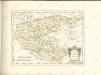

Le Theatre de Bellone :
Mollova mapová sbírka Schenk, Pieter Braakman, Adriaan
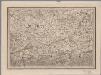
Ducatus Westphaliae Cum annexis
1 : 270000 Mollova mapová sbírka Gigas, Johann Michael Gigas, Johannes
Ducatus Westphaliae Cum annexis
1 : 270000 Mollova mapová sbírka Gigas, Johann Michael Gigas, Johannes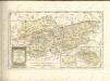

Uebersichts-Karte der Steinkohlenfelder des Rhein-Westfäl. Ruhrkohlenbeckens
1 : 62500 Ostblatt G. D. Baedeker
Meßtischblatt 2507 : Unna, 1936
1 : 250000 Unna. - Hrsg. 1894, bericht. 1927, gedr. [19]36. - 1:25000. - [Berlin]: Reichsamt für Landesaufnahme, 1936. - 1 Kt.
Meßtischblatt 2362 : Ahlen, 1927
1 : 250000 Ahlen. - Aufn. 1895, einz. Nachtr. 1927. - 1:25000. - [Berlin]: Reichsamt für Landesaufnahme, 1927. - 1 Kt.
Meßtischblatt 2363 : Beckum, 1927
1 : 250000 Beckum. - Aufn. 1895, einz. Nachtr. 1927. - 1:25000. - [Berlin]: Reichsamt für Landesaufnahme, 1927. - 1 Kt.
Meßtischblatt 2363 : Beckum, 1897
1 : 250000 Beckum. - Aufn. 1895. - 1:25000. - [Berlin]: Reichsamt für Landesaufnahme, 1897. - 1 Kt.
Comitatvs Marchia et Ravensberg
1 : 270000 Mollova mapová sbírka Schenk, Pieter Schenk, Peter I
Arnsberg 71, uit: Special-Karte von Mittel-Europa / nach amtlichen Quellen bearbeitet von W. Liebenow
1 : 300000 titelvariant: W. Liebenow's Mittel-Europa; Annotatie: Titel boven de bladen: W. Liebenow's Mittel-Europa Johannes Wilhelm Liebenow 1822-1897 Frankfurt a. M. : Ludwig Ravenstein
Ducatus Westphalia
1 : 227000 Vestfálsko (Německo) Seutter, Matthäus sumtibus Matthaei Seutteri
Arnsberg 71, uit: [W. Liebenow's Special-Karte von Mittel-Europa]
1 : 300000 titelvariant: W. Liebenow's Mittel-Europa; Annotatie: Titel boven de bladen: W. Liebenow's Mittel-Europa Johannes Wilhelm Liebenow 1822-1897 Hannover : Hermann Oppermann
Le Comté de la Marck, Les Seigneuries des Abbayes de Werden, d'Essen, et la Ville Imperiale de Dortmundt
1 : 230000 Mollova mapová sbírka Sanson, Guillaume Ottens, Josua
Le Comté de la Marck, Les Seigneuries des Abbayes de Werden, d'Essen, et la Ville Imperiale de Dortmundt
1 : 230000 Mollova mapová sbírka Sanson, Guillaume Jaillot, Alexis Hubert
Westphalia Dvcatvs
1 : 270000 Mollova mapová sbírka Valk, Gerhard Schenk, Peter I
Westphalia Dvcatvs
1 : 270000 Mollova mapová sbírka Janssonius, Johannes Janssonius, Johannes I