Maps of Nördlingen

Tractus Nordlingensis Germ. Ries dicti accurata Descriptio adjecto Indice, cui Dominium cujusvis loci aliaque Iura competant illustrata
1 : 50000 Mollova mapová sbírka Homann, Johann Baptist Homann, Johann Baptista - dědici
Plan allwo die blutige u. fatale Rencontre, zwischen denen fürstl. Ötting. u. Grälich Watterstein. und dann zwischen denen Nördlingern andern theils Vorberg gegangen so geschehen d. 19. Aug. 1726
Mollova mapová sbírka
Meßtischblatt 7028 : Unterschneidheim, 1944
1 : 250000 Unterschneidheim. - Vorläufige Ausg. - 1:25000. - Stuttgart, 1944. - 1 Kt.
Oettingscher Plan, der blutig dencontre so d. 19. Aug. 1726 zwischer vom fürstl. u. gr. ottingl. und Nördlingl. der gefallen
Mollova mapová sbírka
Monacvm, nominatissima Bavariae civitas
Freising (Německo) Braun, Georg Hogenberg, Franz
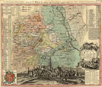
Nordlingen mit der Gegend
Mollova mapová sbírka Bodenehr, Gabriel Bodenehr, Gabriel
Nordlingen mit der Gegend.
1 : 140000 Mollova mapová sbírka Bodenehr, Gabriel Bodenehr, Gabriel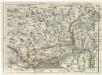
Geographica Provinciarum Sveviae Descriptio =
Mollova mapová sbírka Hurter, Johann Christoph Bodenehr, Gabriel
Mappa Geographica Comitatvs Oettingensis
1 : 100000 Mollova mapová sbírka Cnopf, Matthäus Ferdinand Homann, Johann Baptista - dědici
Geographica Provinciarum Sveviae Descriptio =
Mollova mapová sbírka Hurter, Johann Christoph Bodenehr, Johann Georg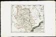
Die Grafschaft Oetingen mit den freyen Reichsstädten Nördlingen Bopfingen und Dünkelsbühl : Nro. 181
Reilly, Franz Johann Joseph von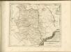

172. Nördlingen, uit: Topographische Uebersichtskarte des Deutschen Reiches / herausgegeben v. d. Kartogr. Abt. d. Königl. Preuß. Landesaufnahme
1 : 200000 titelvariant: Topogr. Übersichtskarte des Deutschen Reiches; Annotatie: Titel boven bladen ook: Topogr. Übersichtskarte des Deutschen Reiches; Annotatie geografische gegevens: Op elk blad twee maatstokken: 10 Kilometer = 5,5 cm; 1 geogr. Meile = 3,6 cm; Legenda onder op elk blad Königlich Preußische Landesaufnahme. Kartographische Abtheilung [S.l : Königlich Preußische Landesaufnahme, Kartographische Abtheilung]
Mappa geographica comitatvs Oettingensis in circulo Sueviceo siti
1 : 100000 Švábsko (Německo) Cnopf, Matthäus Ferdinand edentibus Homanninanis Heredibus
Suevia Universa :
1 : 170000 Mollova mapová sbírka Michal, Jacques de Seutter, Matthäus Seutter, Matthäus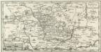
Vorstellung der Teuffels-Mauer in Nordgau und anliegenden Gegenden
1 : 340000 Mollova mapová sbírka
S. R. I. Principatus et Episcopatus Eistettensis
1 : 160000 Mollova mapová sbírka Homann, Johann Baptist Homann, Johann Baptista
S. R. I. principatus et episcopatus Eistettensis cum omnibus suis praefecturis et pertinentiis, tam in proprio, quam in alieno territorio vicinorum statuum sitis
1 : 168000 Bavorsko (Německo) Homann, Johann Baptist Homannovi dědicové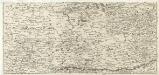
S. R. Imp. Circuli Franconici Geographica Delineatio Francken-Land mit Seinen Gräntzen
Mollova mapová sbírka Endter, Wolfgang Moritz Endter, Wolfgang Moritz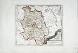
Die Grafschaft Oetingen
1 Karte : Kupferdruck ; 23 x 27 cm Reilly F. J. J. von Reilly
Suevia universa IX. tabulis delineata, 3
1 Blatt : s.n.

Schlacht bey Neresheim am 11.ten August 1796
1 : 170000
Novissima et accurata tabula geographica principalis S. R. I. præposituræ Ellevacensis
1 Karte : Kupferdruck, 48 x 56 cm Seutter; Lotter Matthäus Seutter
Novissima et accurata tabula geographica principalis S.R.I. praepositurae Ellevacensis cum suis praefecturis atque locis eo pertinentibus
1 : 100000 à Matthaeo Seuttero Tob. Conr. Lotter sc. Aug. Vind : [Seutter]
Nova comitatus Pappenheimensis tabula, cum finitimis diversorum imperii statuum locis et tractibus, nec non dynastia Bellenberg in Suevia sita
1 : 90000 Švábsko (Německo) impensis Homannianorum Heredum
Nova Comitatus Pappenheimensis Tabula
1 : 80000 Mollova mapová sbírka Homann, Johann Baptist Homann, Johann Baptista - dědici
A plan of the famous victory at Bleinem obtained by His Grace the Duke of Malborough over the Elector of Bavaria and the Marechals Tallard and Marcin, the 13th August, 1704 S.N
1 : 20000 J. van Vianen fecit [Amsterdam] : Reynerus Leers excudit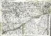
Geographica provinciarum Sueviae descriptio, 4
4 Blätter : Johann Georg Bodenehr