Maps of powiat nyski

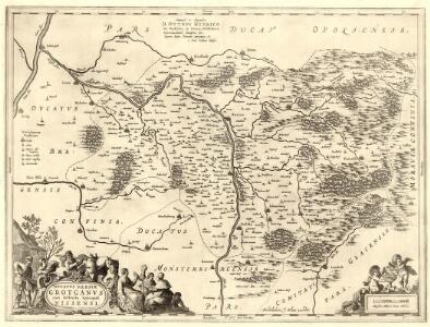
Dvcatvs Silesiae Grotganvs cum Districtu Episcopali Nissensi
1 : 315000 Mollova mapová sbírka Scultetus, Johannes Schenk, Peter I
Dvcatvs Silesiae Grotganvs cum Districtu Episcopali Nissensi
1 : 315000 Mollova mapová sbírka Scultetus, Johannes Blaeu, Joan I.
Special-Carte des Fürstenthums Grotkau oder Neisse in Ober-Schlesien, an den Böhmischen und Mährischen Grentzen
Mollova mapová sbírka Schleuen, Johann David Schleuen, Johann David
Special-Carte des Fürstenthums Grotkau oder Neisse, in Ober-Schlesien, an den böhmischen und mährische[n] Grentzen
1 : 300000 Grodków-oblast (Polsko) Wieland, Johann Wolfgang Schleuen, Johann David I.D. Schleuen
Die Gegend der Stadt und Vestung Neyss Im Herzogthum Schlesien samt denen befindlichen Orthschaften von Drey Meilen im Umcreyß
Mollova mapová sbírka Lidl, Johann Jacob
Jauernig und Weidenau.
from Spezialkarte der osterreichisch-ungarischen Monarchie.
Principatvs Silesiae Mvnsterbergensis exactissima tabula geographica exhibens circulos ejusdem Mvnsterberg et Frankenstein una cum adjacentibus civitatibus Reichenstein et Silberberg ad principatum bregensem alias pertinentibus
1 : 100000 Slezsko Wieland, Johann Wolfgang Schubarth, Matthäus Homannianos Heredes
Hotzenplotz und Zuckmantel.
from Spezialkarte der osterreichisch-ungarischen Monarchie.
Javorník a Ottmachau
1 : 75000 Javorník (Jeseník, Česko : oblast) Vojenský zeměpisný ústav
III. vojenské mapování 3858
1 : 75000
Javorník a Ottmachau
1 : 75000 Javorník (Jeseník, Česko : oblast) Vojenský zeměpisný ústav
III. vojenské mapování 3858
1 : 75000

Javorník
1 : 75000 Javorník (Jeseník, Česko) Vojenský zeměpisný ústav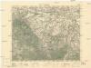
Javorník
1 : 75000 Javorník (Jeseník, Česko : oblast) Vojenský zeměpisný ústav
Cukmantl a Neustadt i. O. Schles
1 : 75000 Polsko Vojenský zeměpisný ústav
Podrobná mapa Markrabství moravského a Vévodství slezkého
1 : 100000 Moravské markrabství Srp, Jan Jos. R. Vilímek
III. vojenské mapování 3858/4
1 : 25000
[Kartenblatt]
1 : 25000 Morava (Česko) Reichsamt für Landesaufnahme

Frývaldov a okolí
1 : 75000 Jeseník (Česko : oblast) Vojenský zeměpisný ústav
Hotzenplotz und Zuckmantel
1 : 75000 Morava (Česko) Radler K. u. k. Militärgeographisches Institut

Das Fürstenthum Münsterberg in Nieder-Schlesien
Mollova mapová sbírka Schleuen, Johann David
III. vojenské mapování 3859
1 : 75000
III. vojenské mapování 3859
1 : 75000

III. vojenské mapování 3858/4
1 : 25000
[Kartenblatt]
1 : 25000 Jeseníky (Česko : pohoří) Reichsamt für Landesaufnahme