Maps of Kreis Paderborn
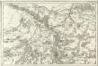
Tableau Topographique Qui comprend la Partie Septentrionale du Landgraviat de Hesse Cassel et de la Principauté de Waldeck, l'Eveché de Paderborn, Partie du Comté de Grubenhague et les Frontieres de ces Etats]
1 : 130000 Mollova mapová sbírka Julien, Roch-Joseph Julien, Roch Joseph
98. Detmold, uit: Topographische Uebersichtskarte des Deutschen Reiches / herausgegeben v. d. Kartogr. Abt. d. Königl. Preuß. Landesaufnahme
1 : 200000 titelvariant: Topogr. Übersichtskarte des Deutschen Reiches; Annotatie: Titel boven bladen ook: Topogr. Übersichtskarte des Deutschen Reiches; Annotatie geografische gegevens: Op elk blad twee maatstokken: 10 Kilometer = 5,5 cm; 1 geogr. Meile = 3,6 cm; Legenda onder op elk blad Königlich Preußische Landesaufnahme. Kartographische Abtheilung [S.l : Königlich Preußische Landesaufnahme, Kartographische Abtheilung]
Composite: 333. Detmold.
1 : 100000 Reichsamt fur Landesaufnahme
333. Detmold.
1 : 100000 Reichsamt fur Landesaufnahme
332. Gutersloh.
1 : 100000 Reichsamt fur Landesaufnahme
Composite: 332. Gutersloh.
1 : 100000 Reichsamt fur Landesaufnahme
Meßtischblatt 2369 : Driburg, 1913
1 : 250000 Driburg. - Aufn. 1896, hrsg. 1898, Aufl.-dr. 1913. - 1:25000. - [Berlin]: Reichsamt für Landesaufnahme, 1913. - 1 Kt.
Meßtischblatt 2368 : Altenbeken, 1898
1 : 250000 Altenbeken. - Aufn. 1896. - 1:25000. - [Berlin]: Reichsamt für Landesaufnahme, 1898. - 1 Kt.
Meßtischblatt 2367 : Paderborn, 1936
1 : 250000 Paderborn. - Hrsg. 1896, bericht. 1922, einz. Nachtr. 1936. - 1:25000. - [Berlin]: Reichsamt für Landesaufnahme, 1936. - 1 Kt.
Meßtischblatt 2367 : Paderborn, 1913
1 : 250000 Paderborn. - Aufn. 1894, hrsg. 1896, Aufl.-dr. 1913. - 1:25000. - [Berlin]: Reichsamt für Landesaufnahme, 1913. - 1 Kt.
Meßtischblatt 2367 : Paderborn, 1907
1 : 250000 Paderborn. - Aufn. 1894, hrsg. 1896, einz. Nachtr. 1907. - 1:25000. - [Berlin]: Reichsamt für Landesaufnahme, 1907. - 1 Kt.
Meßtischblatt 2367 : Paderborn, 1896
1 : 250000 Paderborn. - Aufn. 1894. - 1:25000. - [Berlin]: Reichsamt für Landesaufnahme, 1896. - 1 Kt.
Meßtischblatt 2366 : Delbrück, 1932
1 : 250000 Delbrück. - Hrsg. 1897, bericht. 1912, einz. Nachtr. 1932. - 1:25000. - [Berlin]: Reichsamt für Landesaufnahme, 1932. - 1 Kt.
Meßtischblatt 2295 : Steinheim, 1932
1 : 250000 Steinheim. - Hrsg. 1898, bericht. 1912, einz. Nachtr. 1932. - 1:25000. - [Berlin]: Reichsamt für Landesaufnahme, 1932. - 1 Kt.
Meßtischblatt 2294 : Horn, 1932
1 : 250000 Horn. - Hrsg. 1912, Nachtr. 1932. - 1:25000. - [Berlin]: Reichsamt für Landesaufnahme, 1932. - 1 Kt.
Meßtischblatt 2294 : Sandebeck, 1898
1 : 250000 Sandebeck. - Aufn. 1896. - 1:25000. - [Berlin]: Reichsamt für Landesaufnahme, 1898. - 1 Kt.
Meßtischblatt 2293 : Senne, 1897
1 : 250000 Senne. - Aufn. 1895. - 1:25000. - [Berlin]: Reichsamt für Landesaufnahme, 1897. - 1 Kt.
Meßtischblatt 2292 : Verl, 1932
1 : 250000 Verl. - Aufn. 1895, hrsg. 1897, bericht. 1912, einz. Nachtr. 1932. - 1:25000. - [Berlin]: Reichsamt für Landesaufnahme, 1932. - 1 Kt.
Meßtischblatt 2292 : Verl, 1897
1 : 250000 Verl. - Aufn. 1895. - 1:25000. - [Berlin]: Reichsamt für Landesaufnahme, 1897. - 1 Kt.
Meßtischblatt 4320 : Willebadessen, 1945
1 : 250000 Willebadessen. - Stand 1937. - 1:25000. - [Berlin]: Reichsamt für Landesaufnahme, 1945. - 1 Kt.
Meßtischblatt 2441 : Lichtenau, 1898
1 : 250000 Lichtenau. - Aufn. 1896. - 1:25000. - [Berlin]: Reichsamt für Landesaufnahme, 1898. - 1 Kt.
Meßtischblatt 2440, neue Nr. 4318 : Etteln, 1937
1 : 250000 Etteln. - Hrsg. 1897, einz. Nachtr. 1937. - 1:25000. - [Berlin]: Reichsamt für Landesaufnahme, 1937. - 1 Kt.
Meßtischblatt 2439 : Geseke, 1937
1 : 250000 Geseke. - Hrsg. 1896, einz. Nachtr. 1937. - 1:25000. - [Berlin]: Reichsamt für Landesaufnahme, 1937. - 1 Kt.
Eigentlicher Gründtriß der Statt Paderborn vnd wie solche von Ihr Exell: Herrn Veldt-Marschaln Carol Gustaff Wrangel ein genohmen worden Anno 1646
Mollova mapová sbírka Merian, Matthaeus Merian, Matthäus
Meßtischblatt 2369 : Bad Driburg, 1932
1 : 250000 Bad Driburg. - Hrsg. 1898, bericht. 1912, einz. Nachtr. 1932. - 1:25000. - [Berlin]: Reichsamt für Landesaufnahme, 1932. - 1 Kt.
Meßtischblatt 2370 : Brakel, 1898
1 : 250000 Brakel. - Aufn. 1896. - 1:25000. - [Berlin]: Reichsamt für Landesaufnahme, 1898. - 1 Kt.
Meßtischblatt 2296 : Schwalenberg, 1924
1 : 250000 Schwalenberg. - Aufn. 1896, kl. Nachtr. 1924. - 1:25000. - [Berlin]: Reichsamt für Landesaufnahme, 1924. - 1 Kt.
Meßtischblatt 2443 : Borgholz, 1898
1 : 250000 Borgholz. - Aufn. 1896. - 1:25000. - [Berlin]: Reichsamt für Landesaufnahme, 1898. - 1 Kt.
Meßtischblatt 2219, neue Nr. 4017 : Brackwede, 1937
1 : 250000 Brackwede. - Hrsg. 1897, bericht. 1912, einz. Nachtr. 1932. - 1:25000. - [Berlin]: Reichsamt für Landesaufnahme, 1937. - 1 Kt.
![Tableau Topographique Qui comprend la Partie Septentrionale du Landgraviat de Hesse Cassel et de la Principauté de Waldeck, l'Eveché de Paderborn, Partie du Comté de Grubenhague et les Frontieres de ces Etats]](https://images-2.georeferencer.com/images/iiif/227066598967/full/,300/0/native.jpg)

