Maps of Landkreis Alzey-Worms

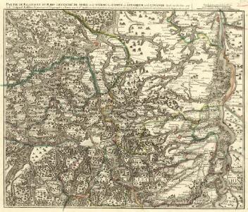
Partie du Cours du Palatinat du Rhin Levesché de Spire et de Worms les Comté de Spanheim et de Linange levée Sur les lieu
1 : 160000 Mollova mapová sbírka Baillieul, Gaspard Bailleul, Gaspard
Le Cours du Rhein, depuis Spire jusqu'a Mayence
1 : 180000 Mollova mapová sbírka Fer, Nicolas de Fer, Nicolas de
Karte eines Theils des ehemaligen Departement des Donnersberges nach Cantons eingetheilt
1 : 178300 Mohuč (Německo : oblast) Veil
Special Carte des Rheinlaufes von Speier bis Bingen nebst den angraentzenden Gegenden von beiden Ufern bis an die Gebirge
1 : 250000 Bingen (Německo) Dewarat, Peter Verhelst, Aegid Schwan und Götz

Carte Particuliere de Pays qui sont situéz entre le Rhein, la Saare, la Moselle, et la Basse Alsace
1 : 150000 Mollova mapová sbírka Jaillot, Alexis-Hubert Jaillot, Alexis Hubert
Territorium Seculare Episcopatus Wormatiensis Tabula Geographica
1 : 130000 Mollova mapová sbírka Homann, Johann Baptist Homann, Johann Baptista - dědici
Section Worms, uit: Charte von dem Grossherzogtum Hessen und dem Herzogtum Nassau / trigonometrisch aufgenommen und hrsg. von C.L.P. Eckhardt
1 : 200000 titelvariant: Karte von Hessen und Nassau Eckhardt, C. L. P Darmstadt : Joh. Wilh. Heyer
Das Rhein-Weinland
1 : 206000 Mohuč-oblast (Německo) Hellrung, Carl Ludwig Baensch, E. Rubach'schen Buchhandlung
150. Mainz, uit: Topographische Uebersichtskarte des Deutschen Reiches / herausgegeben v. d. Kartogr. Abt. d. Königl. Preuß. Landesaufnahme
1 : 200000 titelvariant: Topogr. Übersichtskarte des Deutschen Reiches; Annotatie: Titel boven bladen ook: Topogr. Übersichtskarte des Deutschen Reiches; Annotatie geografische gegevens: Op elk blad twee maatstokken: 10 Kilometer = 5,5 cm; 1 geogr. Meile = 3,6 cm; Legenda onder op elk blad Königlich Preußische Landesaufnahme. Kartographische Abtheilung [S.l : Königlich Preußische Landesaufnahme, Kartographische Abtheilung]
Karte über das Überschwemmungsgebiet des Hochwassers im Winter 1882/83 längs des Main- und Rheinstromes in dem Großherzogthum Hessen
1 : 100000 Hessen-Darmstadt, Großherzogliche Landescultur-Inspection Bergsträsser
Geographica Provinciarum Sveviae Descriptio =
Mollova mapová sbírka Hurter, Johann Christoph Bodenehr, Johann Georg
Le Flambeau de la Guerre Allumee au Rhin
Mollova mapová sbírka Delisle, Guillaume Schenk, Peter II
Geographica Provinciarum Sveviae Descriptio =
Mollova mapová sbírka Hurter, Johann Christoph Bodenehr, Gabriel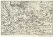
Maintz.
1 : 240000 Mollova mapová sbírka Person, Nikolaus Person, Nicolas
Le Flambeau de la Guerre Allumee au Rhin
Mollova mapová sbírka Delisle, Guillaume Schenk, Peter II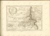

[Charte der Rheingegend von Rhein-Türkheim bis Oppenheim mit dem projektierten Rheindurchstich am Geyer]
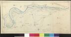
Plan der Seulberger Mark
Lotz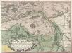
Ein Theil des Hundsrucks mit den angraenzenden Maynz u. Trierischen Laendern :
1 : 95000 Mollova mapová sbírka Homann, Johann Baptist Homann, Johann Baptista - dědici
[32] Sect. Kreuznach, uit: Geologische Karte der Rheinprovinz und der Provinz Westphalen / ausgeführt durch H. von Dechen
1 : 80000 titelvariant: Dechen's geologische Karte vom Rheinland und Westphalen; Annotatie: Titel op bladoverzicht; Incompleet Heinrich von Dechen Berlin : Schropp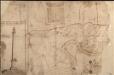
Das Ampt Dornberg
Lichtenberg, Johann Philipp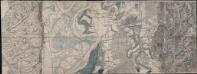
... Bogen der Haasischen Situations Carte
Haas, Johann Heinrich; Lyncker, Ludwig
Karte für die Uebungen der combinirten Kavallerie-Division bei Darmstadt 1877
1 : 50000 Welzbacher, C. Welzbacher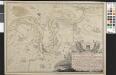
Plan De L'attaque á StockStad et de L'heurese Passage du Rhin de l'Armée Autrichien[n]e sous les Ordres de S. A. S. Le Prince Charle de Lorraine le 2me Juillet 1744
Karge, Johann Friedrich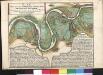
Plan Von Denen Strittigen RheinAuen bey Stockstatt und Leeheim
1 : 25000 Fehr, Peter
Plan Von Denen Strittigen RheinAuen bey Stockstatt und Leeheim
1 : 25000 Fehr, Peter; Hill, Johann Jakob
Meßtischblatt 6516 : Mannheim-Süd, 1944
1 : 250000 Mannheim-Süd. - Aufn. 1910 (Baden 1933), hrsg. 1914, bericht. 19. - 1:25000. - Wiesbaden: Hauptvermessungsabteilung XI, 1944. - 1 Kt.
Meßtischblatt 25 : Ludwigshafen, 1936
1 : 250000 Ludwigshafen. - Aufn. 1910, Ausg. 1914, Erkundung 1935, bericht. 1936. - 1:25000. - [München], 1936. - 1 Kt.