Maps of Lunéville
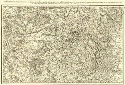
Partie Meridionale du Temporel de l'Evesché de Metz, et Parties des Balliages de Nancy et Allemand, dans le Duché de Lorraine, Divisez par Catellenies, Offices, Prevotez les Terres Adjacentes de Blanmont, de Salme de Sarbourg &.
1 : 180000 Mollova mapová sbírka Jaillot, Alexis-Hubert Jaillot, Alexis Hubert
Dept. De La Meurthe.
1 : 395000 Levasseur, Victor.
Partie meridionale du temporel de l'evesché de Metz
1 Karte : Kupferdruck ; 43 x 67 cm Jaillot Alexis-Hubert Jaillot
Nancy 126, uit: Special-Karte von Mittel-Europa / nach amtlichen Quellen bearbeitet von W. Liebenow
1 : 300000 titelvariant: W. Liebenow's Mittel-Europa; Annotatie: Titel boven de bladen: W. Liebenow's Mittel-Europa Johannes Wilhelm Liebenow 1822-1897 Frankfurt a. M. : Ludwig Ravenstein
Levci
1 Karte : Kupferdruck ; 41 x 56 cm Sanson; Robert de Vaugondy chés le Sr. Robert g. du roi quai de l'horloge
Nancy 126, uit: [W. Liebenow's Special-Karte von Mittel-Europa]
1 : 300000 titelvariant: W. Liebenow's Mittel-Europa; Annotatie: Titel boven de bladen: W. Liebenow's Mittel-Europa Johannes Wilhelm Liebenow 1822-1897 Hannover : Hermann Oppermann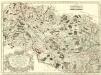
Archidiacnés de Port, et Prevosté de St. Diey, dans l'Evesché de Tovl
1 : 240000 Mollova mapová sbírka Sanson, Nicolas Mariette, Pierre Sanson, Nicolas II
Departement de la Meurte
1 Karte : Kupferdruck ; 17 x 16 cm au dépot de l'Atlas national rue de la Monnoye no. 5
168. Pfalzburg, uit: Topographische Uebersichtskarte des Deutschen Reiches / herausgegeben v. d. Kartogr. Abt. d. Königl. Preuß. Landesaufnahme
1 : 200000 titelvariant: Topogr. Übersichtskarte des Deutschen Reiches; Annotatie: Titel boven bladen ook: Topogr. Übersichtskarte des Deutschen Reiches; Annotatie geografische gegevens: Op elk blad twee maatstokken: 10 Kilometer = 5,5 cm; 1 geogr. Meile = 3,6 cm; Legenda onder op elk blad Königlich Preußische Landesaufnahme. Kartographische Abtheilung [S.l : Königlich Preußische Landesaufnahme, Kartographische Abtheilung]
142 Nancy.
1 : 86400 Cassini family; Cassini, Cesar-Francois, 1714-1784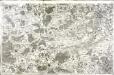
[Nancy]
1 Blatt : 60 x 91 cm Desfontaines s.n.
Les Environs de la Ville de Nancy Capitale du Duché de Lorraine ou se trouve ce qui depend de son Office, Chatellenie, Balliage et Banlieue
1 : 140000 Mollova mapová sbírka Ville de Courtenayn, de Nolin, Jean Baptiste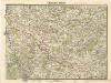
Chateau Salins

Meßtischblatt [7509] : Schirmeck, 1885
1 : 250000 Schirmeck. - 1:25000. - [Berlin]: Reichsamt für Landesaufnahme, 1885. - 1 Kt.
Meßtischblatt 3625 : Blen, 1916
1 : 250000 Blen. - Aufn. 1883, hrsg. 1885, B. 09, N. 13, Aufldr. 1916. - 1:25000. - [Berlin]: Reichsamt für Landesaufnahme, 1916. - 1 Kt.
Meßtischblatt 3621 : Lützelhausen, 1909
1 : 250000 Lützelhausen. - Aufn. 1882. - 1:25000. - [Berlin]: Reichsamt für Landesaufnahme, 1909. - 1 Kt.
Meßtischblatt 3621 : Lützelhausen, 1883
1 : 250000 Lützelhausen. - Aufn. 1882. - 1:25000. - [Berlin]: Reichsamt für Landesaufnahme, 1883. - 1 Kt.
Meßtischblatt 3620 : Lascemborn, 1883
1 : 250000 Lascemborn. - Aufn. 1882. - 1:25000. - [Berlin]: Reichsamt für Landesaufnahme, 1883. - 1 Kt.
Meßtischblatt 3614 : Alberschweiler, 1884
1 : 250000 Alberschweiler. - Aufn. 1882. - 1:25000. - [Berlin]: Reichsamt für Landesaufnahme, 1884. - 1 Kt.
Meßtischblatt 3613 : Rixingen, 1917
1 : 250000 Rixingen. - Aufn. 1882, hrsg. 1883, Aufl.-dr. 1917. - 1:25000. - [Berlin]: Reichsamt für Landesaufnahme, 1917. - 1 Kt.
Meßtischblatt 3613 : Rixingen, 1883
1 : 250000 Rixingen. - Aufn. 1882. - 1:25000. - [Berlin]: Reichsamt für Landesaufnahme, 1883. - 1 Kt.
Meßtischblatt 3612 : Elfringen, 1917
1 : 250000 Elfringen. - Aufn. 1881, hrsg. 1883, Aufldr. 1917. - 1:25000. - [Berlin]: Reichsamt für Landesaufnahme, 1917. - 1 Kt.
Meßtischblatt 3606 : Pfalzburg, 1884
1 : 250000 Pfalzburg. - Aufn. 1882. - 1:25000. - [Berlin]: Reichsamt für Landesaufnahme, 1884. - 1 Kt.
Meßtischblatt 3605 : Saarburg (In Lothringen), 1883
1 : 250000 Saarburg (In Lothringen). - Aufn. 1882. - 1:25000. - [Berlin]: Reichsamt für Landesaufnahme, 1883. - 1 Kt.
Meßtischblatt 3604 : Langenberg, 1883
1 : 250000 Langenberg. - Aufn. 1882. - 1:25000. - [Berlin]: Reichsamt für Landesaufnahme, 1883. - 1 Kt.
Meßtischblatt 3603 : Maizières, 1914
1 : 250000 Maizières. - Aufn. 1881, hrsg. 1883, Aufldr. 1914. - 1:25000. - [Berlin]: Reichsamt für Landesaufnahme, 1914. - 1 Kt.
Meßtischblatt 3601 : Kambrich, 1917
1 : 250000 Kambrich. - Aufn. 1881, hrsg. 1883, Aufldr. 1917. - 1:25000. - [Berlin]: Reichsamt für Landesaufnahme, 1917. - 1 Kt.
Meßtischblatt 3592 : Duß, 1917
1 : 250000 Duß. - Aufn. 1881, hrsg. 1883, Aufldr. 1917. - 1:25000. - [Berlin]: Reichsamt für Landesaufnahme, 1917. - 1 Kt.
Meßtischblatt 3591 : Château- Salins, 1917
1 : 250000 Château- Salins. - Aufn. 1881, hrsg. 1883, Aufldr. 1917. - 1:25000. - [Berlin]: Reichsamt für Landesaufnahme, 1917. - 1 Kt.