Maps of Rheingau-Taunus-Kreis

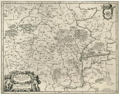
Nova et Accurata Moguntini Archiepiscopatus delineatio
1 : 620000 Mollova mapová sbírka Janssonius, Johannes Janssonius, Johannes I
Inferioris Comitatvs Cattimelibocensis delineatio geographica una cum confiniis
1 : 75000 Homann
Carte geographique du Comte Inferievr de Cazenelnbogen, mise au jour par les Heritiers de Homann. Avec Pr. Imperial. l'An. 1745
1 : 75000 Mollova mapová sbírka Homann, Johann Baptist Homann, Johann Baptista - dědici
Le Flambeau de la Guerre Allumee au Rhin
Mollova mapová sbírka Delisle, Guillaume Schenk, Peter II
Die Nider Graffschafft Catzenellenbogen Sampt dero angrentzende Länder
1 : 80000 Mollova mapová sbírka Person, Nikolaus Person, Nicolas
Le Flambeau de la Guerre Allumee au Rhin
Mollova mapová sbírka Delisle, Guillaume Schenk, Peter II
Carte Particuliere de Pays qui sont situéz entre le Rhein, la Saare, la Moselle, et la Basse Alsace
1 : 150000 Mollova mapová sbírka Jaillot, Alexis-Hubert Jaillot, Alexis Hubert
Karte von der Gegend bey Homburg vor der Höhe und dasigen Gebürgen
1 : 90000 Coentgen, Heinrich Hugo
Die Umgebung von Homburg = The environs of Homburg
1 : 75000 gez[eichnet] von Fritz Schick Bad Homburg : Louis Schick
Situation von der Vestung Rheinfels
Hill, Johann Jakob
Franckfurt mit der Gegend auf 2 Stund.
1 : 150000 Mollova mapová sbírka Bodenehr, Gabriel Bodenehr, Gabriel
Abbildung der Keysrl. Freyen- Reichs- Wahl. und Handelstatt Franckfurt am Mayn mit ihrem Gebiet umd Gräntzen vorgestlt von Ioh. Bapt. Homann in Nürnberg
1 : 100000 Mollova mapová sbírka Homann, Johann Baptist Homann, Johann Baptista - dědici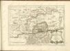
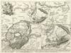
Battaille de Bergen près de Francofort gagneé par S. E. le duc de Brogliè sur S. A. le Pr. Ferdinand le 13 Avril 1759
1 : 60000 Mollova mapová sbírka Back, Jakob Conrad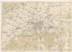
Karte vom Stadt und Landkreis Frankfurt a. M.

Abbildung der Keys[e]rl. Freyen Reichs-, Wahl- und Handelstatt Franckfurt am Mayn mit ihrem Gebiet und Gräntzen
1 : 65000 Homann, Johann Baptist
Abbildung der keysrl. Freyen-Reichs-Wahl-und-Handelstatt Franckfurt am Mayn mit ihrem Gebiet und Gräntzen
1 : 65000 Homann, Johann Baptist Ioh. Baptist Homann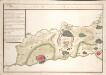
Plan de la Bataille de Bergen gagneé par Mr. Le Duc de Broglio Suv Le Prince Ferdinand Le 13. Avril 1759

Plan von Frankfurt am Main

Meßtischblatt 3371 (35) : Frankfurt a.M. West (Steinbach), 1934
1 : 250000 Frankfurt a.M. West (Steinbach). - Hrsg. 1906, bericht. 1931, einz. Nachtr. 1934. - 1:25000. - [Berlin]: Reichsamt für Landesaufnahme, 1934. - 1 Kt.
Meßtischblatt 3371 : Höchst, 1906
1 : 250000 Höchst. - Aufn. 1904. - 1:25000. - [Berlin]: Kgl. Preuss. Landesaufnahme, 1906. - 1 Kt.
Meßtischblatt 43 : Rödelheim, 1876
1 : 250000 Rödelheim. - Aufn. 1867. - 1:25000. - [Berlin]: Kgl. Min. f. Handel, 1876. - 1 Kt.
Meßtischblatt 3370 : Königstein am Taunus, 1876
1 : 250000 Königstein am Taunus. - Aufn. 1868. - 1:25000. - [Berlin]: Kgl. Min. f. Handel, 1876. - 1 Kt.
Meßtischblatt 3369 : Wehen, 1906
1 : 250000 Wehen. - Aufn. 1904. - 1:25000. - [Berlin]: Kgl. Preuss. Landesaufnahme, 1906. - 1 Kt.
Meßtischblatt 3369 : Platte, 1876
1 : 250000 Platte. - Aufn. 1867. - 1:25000. - [Berlin]: Kgl. Min. f. Handel, 1876. - 1 Kt.
Meßtischblatt 3367 : Nastätten, 1907
1 : 250000 Nastätten. - Aufn. 1904/05. - 1:25000. - [Berlin]: Kgl. Preuss. Landesaufnahme, 1907. - 1 Kt.
Meßtischblatt 39 : Algenroth, 1876
1 : 250000 Algenroth. - Aufn. 1867. - 1:25000. - [Berlin]: Kgl. Min. f. Handel, 1876. - 1 Kt.
Meßtischblatt 3368 : Langenschwalbach, 1907
1 : 250000 Langenschwalbach. - Aufn. 1904/05. - 1:25000. - [Berlin]: Reichsamt für Landesaufnahme, 1907. - 1 Kt.
Meßtischblatt 3368 : Langenschwalbach, 1894
1 : 250000 Langenschwalbach. - Aufn. 1867/68, hrsg. 1876, einz. Nachtr. 1894. - 1:25000. - [Berlin]: Kgl. Min. f. Handel, 1894. - 1 Kt.
Meßtischblatt 5812 : St. Goarshausen, 1941
1 : 250000 St. Goarshausen. - Aufn. 1901, hrsg. 1903, bericht. 1935, letzte Nachtr. 1940, Ausg. 1941, Nur für d. Dienstgebrauch!. - 1:25000. - [Berlin]: Reichsamt für Landesaufnahme, 1941. - 1 Kt.
Meßtischblatt 3366 : St. Goarshausen, 1917
1 : 250000 St. Goarshausen. - Aufn. 1901, hrsg. 1903, Auflagendr. 1917, B[ericht. 19]05. N[achtr. 19]14. - 1:25000. - [Berlin]: Kgl. Preuss. Landesaufnahme, 1917. - 1 Kt.