Maps of Harz

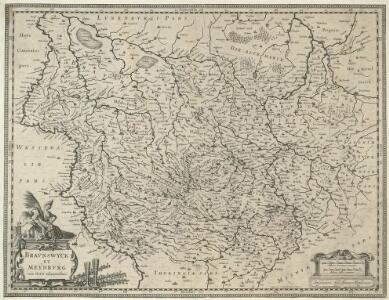
Bravnswyck et Meydbvrg cum terris adjacentibus
1 : 690000 Mollova mapová sbírka Hamersveldt, Everard S. van Rogiers, Salomon Janssonius, Johannes I
Bravnswyck & Meydbvrg
1 : 740000 Mollova mapová sbírka Valk, Gerhard Schenk, Peter I
Inter valla Viaeque publicae Electoratus Saxoniae cursorum publicorum distantiis definitae suisque mensuris descripta
1 : 440000 Mollova mapová sbírka Seutter, Albrecht Carl Glasser, Johann Friedrich Seutter, Albrecht Carl
Das Harz- und Thüringer-Waldgebirge im Jahre 1824
Neuhaldensleben : Eijraud
Karte der Thüringer Eisenbahn
1 : 218000 Kunstanstalt von Mädel II
Landgraviat Thuringiae
1 : 350000 Durynsko (Německo) Homann, Johann Baptist Ioh. Bapt. Homann
Landgraviat Thuringiae
1 : 350000 Durynsko (Německo) Homann, Johann Baptist Ioh. Bapt. Hom[a]nn
Illustrissimo Principi Ioanni Georgio duci Saxoniae hanc Thuringiae Lantgraviatus Tabulam omni animi devotione offert et inscribit
1 : 340000 Mollova mapová sbírka Schenk, Pieter Schenk, Peter I
Special Charte von dem Harz-Gebirge und den umliegenden Ländern
Harz-oblast (Německo) von dem Geographischen Institute
[Durynsko a saská vévodství na západ od Sály]
1 : 340000 Durynsko (Německo)
Landgraviat Thuringiae tabula generalis in suos principatvs et sta[t]vs accurate divi[sa]
1 : 350000 Durynsko (Německo) Homann, Johann Baptist Homann, Johann Christoph curantibus Homannianis Heredibus


Thuringiae Nova Descriptio [Karte], in: Gerardi Mercatoris et I. Hondii Newer Atlas, oder, Grosses Weltbuch, Bd. 1, S. 298.
1 Karte aus Atlas Mercator, Gerhard und Hondius, Jodocus Jansson, Jan
Thuringia Lantgraviatus. [Karte], in: Novus atlas absolutissimus, Bd. 2, S. 72.
1 Karte aus Atlas Janssonius Offizin
Turingiae Noviss. Descript. [Karte], in: Theatrum orbis terrarum, S. 137.
1 Karte aus Atlas Ortelius, Abraham
Thuringia Landgraviatus [Karte], in: Novus Atlas, das ist, Weltbeschreibung, Bd. 1, S. 159.
1 Karte aus Atlas Blaeu, Joan Blaeu, Willem Janszoon
Turingiae Noviss. Descript. [Karte], in: Theatrum orbis terrarum, S. 229.
1 Karte aus Atlas Ortelius, Abraham Vrients, Jan Baptista
Landgrafschafft Thüringen mit ihren abgetheilten Provintzen im Ober Sächßischen Creisse
1 : 1000000 Mollova mapová sbírka Weigel, Christoph Weigel, Christoph I.
Thvringia landgraviatvs / auct. Adolario Erichio Anderslebiano
1 : 308000 Annotatie: Met opdracht aan Ioachim Vicofortius; Origineel is Blad 101 in atlas factice; Annotatie geografische gegevens: Met schaalstok: Milliaria Germanica communia Joan Blaeu 1597/98-1673; Cornelis Blaeu ca. 1610-1645 [Amsterdam : Johan. et Cornelium Blaeu]
Landgraviat de Thuringe Traduit de l'Allemand
1 : 350000 Mollova mapová sbírka Le Rouge, Georges-Louis Le Rouge, Georges-Louis
Thuringia Landgraviatus [Karte], in: Le théâtre du monde, ou, Nouvel atlas contenant les chartes et descriptions de tous les païs de la terre, Bd. 1, S. 190.
1 Karte aus Atlas Blaeu, Willem Janszoon und Blaeu, Joan Blaeu, Willem Janszoon
Landgraviatus Thuringiae juxta recentiss: designation in suos Principatus, Status et Praefecturas accuratissme divisus studio et impensis
1 : 350000 Mollova mapová sbírka Seutter, Matthäus Lotter, Tobias Conrad Seutter, Matthäus
Landgraviat. Thuringiae Tabula Generalis in suos Principatvs et Statvs accurate divi.
1 : 350000 Mollova mapová sbírka Homann, Johann Baptist Homann, Johann Baptista - dědici
Landgraviat Thuringiae Tabula Generalis in suos Principatvs et Statvs accurate divi.
1 : 350000 Mollova mapová sbírka Homann, Johann Baptist Homann, Johann Baptista
Thuringia Landgraviatus [Karte], in: Theatrum orbis terrarum, sive, Atlas novus, Bd. 1, S. 248.
1 Karte aus Atlas Blaeu, Joan Blaeu, Willem Janszoon
Thuringia [Karte], in: Gerardi Mercatoris Atlas, sive, Cosmographicae meditationes de fabrica mundi et fabricati figura, S. 379.
1 Karte aus Atlas Mercator, Gerhard Montanus, Petrus
Thvringia Landgraviatvs
1 : 300000 Mollova mapová sbírka Erich, Adolar Blaeu, Cornelis
Tvringiae noviss. descript
1 Karte : Kupferdruck ; 28 x 20 cm Mellinger; Ortelius s.n.