Maps of Belgium

Nova et Accuratißima Galliae Tabula, Vulgo Royaume De France
1 : 920000 Mollova mapová sbírka Danckerts, Justus Danckerts, Justus
Provinciae Belgii Regii Distinctae eo, quo Sunt hodie divisae modo Inter Regem Galiae, Hispaniae et Ordines Provinciarum Faederatarum
1 : 740000 Mollova mapová sbírka Danckerts, Justus Danckerts, Justus
Provinciae Belgii regii distinctae eo, quo sunt hodie divisae modo inter regem Galliae, Hispaniae et ordines provinciarum faederatarum tabula novissima et accuratissima
1 : 740000 1 Karte : Kupferdruck ; 49 x 56 cm Danckerts, Justus [Danckerts]
Provinciae Belgii regii
1 : 760000 Belgie Danckerts, Justus Iusto Danckerts
PROVINCIAE BELGII REGII
1 : 760000 Belgie Danckerts, Justus Iusto Danckerts


Des Burgundischen Creisses Südlicher theil oder Oesterreichissche Niederlande
1 : 2250000 Mollova mapová sbírka Weigel, Christoph Weigel, Christoph I. - dědici
Belgivm Regivm accuratissime descriptum
1 : 1200000 Mollova mapová sbírka Weigel, Christoph Kauffer, Michael Weigel, Christoph I.
A map of the seat of war in France, with the country divided into its several departments
1 : 2600000
Les Provinces des Pays-Bas Catholiques [...] [Karte], in: Atlas nouveau, contenant toutes les parties du monde [...], Bd. 2, S. 20.
1 Karte aus Atlas Sanson, Nicolas Jaillot, Alexis Hubert und Mortier, Pieter
Arena Martis in Belgio
1 : 830000 Mollova mapová sbírka Homann, Johann Baptist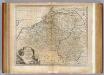
Netherlands or Low Countries.
1 : 980000 Bowen, Emanuel
Belgii Pars Meridionalis
1 : 820000 Mollova mapová sbírka Visscher, Nicolaes Schenk, Pieter Schenk, Peter II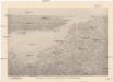
Reliefkarte des Kanals von Cherbourg bis zur Scheldemündung
Anglie jihovýchodní Franckh'sche Verlagshandlung
Arena martis in Belgio, qua provinciae X. catholicae inferioris Germaniae
1 : 850000 Belgie Homann, Johann Baptist J. B. Homann

Nova totius Belgii regii tabula
1 : 762000 Belgie Wit, Frederick de Frederick de Wit

Belgium Regium Accuratissime Divisum. &c: Ad Usum Serenissimi Burgundiae Ducis. Authore G. de l'Isle, Geographe
1 : 710000 Mollova mapová sbírka Delisle, Guillaume Luchtenburg, Johannes van Covens, Johannes I
Carte historique de la Belgique au moyen age / par Louis Delgeur
1 : 1135400 Delgeur, Louis [Bruxelles : Vandermaelen]
Belgii Regii Accuratissima Tabula
1 : 620000 Mollova mapová sbírka Wit, Frederik de Ottens, Josua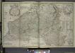
Les provinces des pays-bas Catholiques, ou a most exact map of Flanders or Austrian Netherlands &c.
from The world described, or, A new and correct sett of maps : shewing the kingdoms and states in all the known parts of the earth, with the principal cities, and most considerable towns in the world ... / ... by Herman Moll, geographer ...
Belgii Regii accuratissima Tabula. [Karte], in: Novus atlas absolutissimus, Bd. 3, S. 25.
1 Karte aus Atlas Janssonius Offizin
Belgii regii tabula
1 : 822000 Belgie Visscher, Nicolaes Jansz. per Nicolaum Visscher
BELGII REGII accuratissima Tabula
1 : 810000 Belgie Visscher, Nicolaus Nicolao Visscher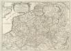
Prouincie Meridionali de Paesi Bassi. Intese sotto nome di Fiandra ouero Li Paesi Bassi Cattolici
1 : 875000 Mollova mapová sbírka Sanson, Nicolas Widman, Giorgio De Rossi, Giovanni Giacomo
La partie Meridionale des Pays Bas, Connue sous le nom de Flandre
1 : 840000 Mollova mapová sbírka Nolin, Jean-Baptiste Nolin, Jean Baptiste
Belgium Regium divisum in decem provincias, nempe ducatus Brabantiae, Limburgi, Lucisburgi, Geldriae ; comitatus Flandriae, Artesiae, Namurci, Hannoniae, Marchionatum Antverpiae, Imperium Machliniensis, ceterasque adsitas regiones delineatum
1 : 650000 per Gerardum et Leonardum Valk [Amsterdam] : Gerard et Leonard Valk
Germaniae inferioris sive Belgii pars meridionalis
1 : 853800 Belgie Lotter, Tobias Conrad M. Tob Conr. Lotter


