Maps of Germany

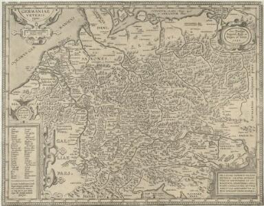
Germaniae Veteris typus
1 : 3600000 Mollova mapová sbírka Ortelius, Abraham
Germania Antiqua.
1 : 2900000 Mollova mapová sbírka Sanson, Nicolas Covens, Johannes I
Neueste Post Karte von Deutschland und dessen angrenzenden Laendern
Evropa střední Walch, Johann Ioh. Walch
Neueste Post Karte von Deutschland und dessen angrenzenden Laendern
Evropa střední Walch, Johann bei Joh. Walch
Neueste Post Karte von Deutschland und dessen angrenzenden Laendern
Evropa střední Knittel, Joh. Ernst Campe, Friedrich Friedrich Campe
L'Allemagne.
1 : 3700000 Clouet, J. B. L. (Jean-Baptiste Louis), b. 1730
(L'Allemagne)
1 : 12000000 Bruyset, Jean-Marie; Schneider, J. H.
Germany.
1 : 5500000 Moll, Herman, d. 1732
Post Charte von Teutschland
1 : 1750000 Evropa střední Güssefeld, Franz L. Geograph. Institut
Post Karte durch ganz Deutschland
Evropa střední Walch, Johann Joh. Walch
Deutschland u. Italien im früheren Mittelalter
Evropa střední R. Gaertner
Post Karte durch ganz Deutschland
1 : 2100000 Evropa střední Walch, Johann bey Joh. Walch
Mappa chorographica Omnivm Episcopatvvm Germaniae ab AC. MD ad MDCCLX existentium
1 : 2600000 Mollova mapová sbírka Hartzheim, Josephus Homann, Johann Baptista - dědici
Reise Charte durch Deutschland
1 : 7400000 Mollova mapová sbírka Schreiber, Johann Georg Schreiber, Johann Georg
General-Charte von Teutschland nach den besten Quellen bearbeitet und den neuesten politischen Veraenderungen begrenzt
1 : 2027520
Regni Germaniae delineatio, secundum X. Circulorum divisionem veram suam figuram hodiernos circulorum et regni totius exacte referens
1 : 7900000 Mollova mapová sbírka Franz, Johann Michael Homann, Johann Baptista - dědici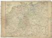
Neue und vollstaendige Post-Carte durch ganz Deutschland und die benach barten Lande
1 : 1850000 Evropa střední Güssefeld, Franz L. Heritiers de Chr. Weigel & Schneider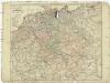
Neue und vollstaendige Post-Carte durch ganz Deutschland und die benach barten Lande
1 : 1850000 Evropa střední Güssefeld, Franz L. Heritiers de Chr. Weigel & Schneider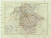
Deutschland nach den letzten Friedenschlüssen
1 : 3600000 Evropa střední Mollo, Tranquillo bey Tranquillo Mollo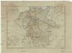
Deutschland nach den letzten Friedenschlüssen
1 : 3600000 Evropa střední Mollo, Tranquillo Tranquillo Mollo
[Historisch-geographischer Atlas zu den allgemeinen Geschichtswerken von C. v. Rotteck, Pölitz u. Becker] : Deutschland zur Uebersicht nach seiner Kreiseintheilung
von Julius Loewenberg Lithographie von B. Herder in Freiburg im Breisgau 1839 [Freiburg im Breisgau] : [Herder]
Karte der fahrbaren oder im Bau begriffenen und der ernstlich projectirten Eisenbahnen in Deutschland, Belgien und Holland, so wie desgleichen einiger in Frankreich, in der Schweiz, in Italien und in Polen
1 : 2470000 Belgie Müller, Emil bey Hoffmann & Campe
[Recto], uit: Post- und Eisenbahn-Karte von Deutschland, den Niederlanden, Belgien und der Schweiz / bearb. nach L. Friedrich's Post-, Eisenbahn- & Reisekarte von Mittel-Europa
1 : 1800000 Annotatie: Ondertitel op omslag: Bis Calais & Paris, Rügen & Königsberg, Krakau & Pesth, Venedig & Grenoble Gotha : Perthes
Germania secundum observationes recentissimas in suos circulos divisa
1 : 2313000 Německo Walch, Johann Ioanes Walch
Germania secundum observationes recentissimas in suos circulos divisa
1 : 2313000 Německo Walch, Johann Ioanes Walch
Societas Jesu Germana sive Assistentia Germaniae
1 : 2800000 Evropa střední Hartzheim, Franc. Matth. Seutt.
Deutschland und anliegende Länder zur Übersicht, d Hauptstr. u. Entfernungen zw. Paris, Mailand, Warschau u. Königsberg
1 : 3800000 Evropa střední Stieler, Adolf Justus Perthes
Neue Post-Karte von Teutschland zum altgemeinen Postbuch von Teutschland
1 : 2000000 Diez, Franz Maximilian 1761-1851 Berlin : C. Jack