Maps of Italy

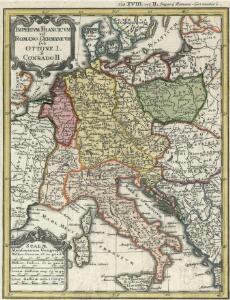
Imperivm Francicvm vel Romano-Germanicvm svb Ottone I. & Conrado II.
1 : 11000000 Mollova mapová sbírka Homann, Johann Baptist Homann, Johann Baptista - dědici
Tab. IV. Imperii Francici vel Romano German S. Romani Occid.
1 : 8500000 Mollova mapová sbírka Homann, Johann Baptist Homann, Johann Baptista - dědici
Tab. IV. Imperii Francici vel Romano-German. S. Romani Occid.
1 : 8500000 Mollova mapová sbírka Homann, Johann Baptist Homann, Johann Baptista - dědici
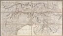
Tab. IV. Imperii Francici vel Romano-German. S. Romani Occid.
1 : 8500000 Mollova mapová sbírka Homann, Johann Baptist Homann, Johann Baptista - dědici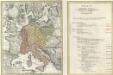
Tab. IV. Imperii Francici vel Romano-German. S. Romani Occid.
1 : 8500000 Mollova mapová sbírka Homann, Johann Baptist Homann, Johann Baptista - dědici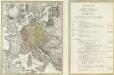
Tab. IV. Imperii Francici vel Romano-German. S. Romani Occid.
1 : 8500000 Mollova mapová sbírka Homann, Johann Baptist Homann, Johann Baptista - dědici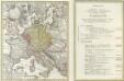
Tab. IV. Imperii Francici vel Romano-German. S. Romani Occid.
1 : 8500000 Mollova mapová sbírka Homann, Johann Baptist Homann, Johann Baptista - dědici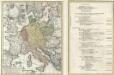
Tab. IV. Imperii Francici vel Romano-German. S. Romani Occid.
1 : 8500000 Mollova mapová sbírka Homann, Johann Baptist Homann, Johann Baptista - dědici
Karte der Eisenbahnen Mittel-Europa's
1 : 1850000 Evropa střední Müller, H. C. Flemming
Mitteleuropa
1 : 3000000 Evropa střední Kartogr. Anstalt G. Freytag & Berndt
Post- und Eisenbahn-Reisekarte, Deutschland Holland, Belgien, die Schweiz, Italien bis Neapel, der größte Theil von Frankreich, Ungarn, Polen etc
Belgie Hanser, Gustav Serz & C.ie
Post- und Eisenbahn-Reisekarte, Deutschland Holland, Belgien, die Schweiz, Italien bis Neapel, der größte Theil von Frankreich, Ungarn, Polen etc
Belgie Hanser, Gustav Serz
Post- und Eisenbahn-Reisekarte
Belgie Hanser, Gustav Serz & C.ie
Post- und Eisenbahn-Reisekarte, Deutschland Holland, Belgien, die Schweiz, Italien bis Neapel, der größte Theil von Frankreich, Ungarn, Polen etc
Belgie Hanser, Gustav A. Paterno's W.we & Sohn
Post- und Eisenbahn-Reisekarte, Deutschland Holland, Belgien, die Schweiz, Italien bis Neapel, der größte Theil von Frankreich, Ungarn, Polen etc
Belgie Hanser, Gustav A. Paterno's W.we & Sohn
Marche des Lombards à travers l’Europe
Italien Langobarden Völkerwanderungszeit Völkerwanderung
Veränderungen der Karte von Europa seit 1815
1 : 3800000 Evropa Wenzel, Joh. K. J.G. Calve'sche k. k. Hof- und Universitäts-Buchhandlung
Imperivm Francicvm vel Romanvm Occidentale Posterivs sub ipso Carolo Magno
1 : 28000000 Mollova mapová sbírka Homann, Johann Baptist Homann, Johann Baptista - dědici
Sbírka map a diagramů použitých na mírových konferencích v Paříži v letech 1919 - 1920

Germany.
from A new systeme of the mathematicks: containing I. Arithmetick, as well natural and decimal, as in species, or the principles of algebra. II. Practical geometry, together with the first six books of Euclid's Elements, as also the eleventh and twelfth, symbo
Neueste Post und Reise Karte der wichtigsten und besuchtesten Theile Europa's
1 : 3700000 Evropa střední Kliewer, Friedrich Wilhelm Heymann, Carl Carl Heymann
Post - und Eisenbahn – Reisekarte Deutschland

Imperivm Romano-Germanicvm sub exitum Caroli VI Austriaci.
1 : 11000000 Mollova mapová sbírka Homann, Johann Baptist Homann, Johann Baptista - dědici
Říše Karla Velikého

Post und Eisenbahn - Reisekarte Deutschland, Holland, Belgien...

Nova et Accurata Mappa Geographica
1 : 2500000 Mollova mapová sbírka Lidl, Johann Jakob Lidl, Johann Jacob
Střední Evropa v době náboženské reformace a protireformace 1517 - 1648
[2], uit: Carte de la partie septentrionale de l'Italie / par Chauchard
1 : 560000 Chauchard (capitaine) Paris : Dezauche
Völkerkarte von Mitteleuropa
1 : 9000000 Mitteleuropa Ethnische Gruppe