Maps of Germany
Carte von Ober u. Nieder Teutschland
1 : 4500000 Mollova mapová sbírka Vogel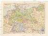
Deutsches Reich
1 : 3250000 Evropa střední Staatliche Verlagsanstalt
Bojiště francouzsko-německé
Evropa severozápadní Gréger a Ferd. Dattel
Mappa Geographica indicans, quibus in locis per totam Germaniam bello tricennali Rex Sueciae Gustavus Adolphus, ejusque Confoederati felicia ut plurimum praelia comiserint, quas urbes tenuerint et A. 1648 amore Pacis vi tractatum Westphalicarum restituere promiserint
1 : 2500000 Mollova mapová sbírka Seutter, Matthäus Seutter, Matthäus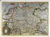
Germania
1 Karte : Kupferdruck ; 34 x 47 cm Mercator; Hondius Henricus Hondius
Germania
1 Karte : Kupferdruck ; 34 x 47 cm Mercator s.n.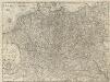
Die Zehen Kraise des H. Römischen Reichs
1 : 3400000 Mollova mapová sbírka
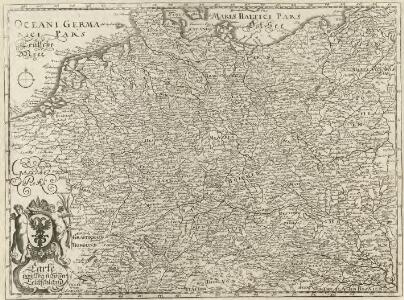
Nova Totivs Germaniae Descriptio
1 : 3500000 Mollova mapová sbírka Walter, A. Walter, Anton
Nova Totivs Germaniae Descriptio
1 : 3300000 Mollova mapová sbírka Blaeu, Willem Janszoon Blaeu, Joan I.
Carte exacte des Postes et Routes de l'Empire d'Allemagne
1 : 2500000 Mollova mapová sbírka Delisle, Guillaume Covens, Johannes I
L'Empire d'Allemagne
1 : 2400000 Mollova mapová sbírka Jaillot, Alexis-Hubert Broen, Gerrit de Jaillot, Alexis Hubert
Neu vermehrte Post Charte durch gantz Teutschland nach Italien, Franckreich, Niederland, Preußen, Polen, und Ungarn &c.

Die Ältesten Karten von Deutschland

Neue Post-Karte von Teutschland zum altgemeinen Postbuch von Teutschland
1 : 2000000 Diez, Franz Maximilian 1761-1851 Berlin : C. Jack
Mappa geographica exhibens postas omnes tam vehiculares quam veredarias totius Germaniae
Evropa střední Lotter, Tobias Conrad Tobias Conrad Lotter
Mappa geographica exhibens postas omnes tam vehiculares quam veredarias totius Germaniae
Evropa střední Lotter, Tobias Conrad Tobias Conrad Lotter
Mappa geographica exhibens postas omnes tam vehiculares quam veredarias totius Germaniae
Evropa střední Lotter, Tobias Conrad Tobias Conrad Lotter
S[anctum] Imperium Romano-Germanicum oder Teutschland Mit Seinen Angräntzenden Königreichen Und Provincien
Reichelt, Julius; Visscher, Nicolaes; Hogeboom, Andries
[Střední Evropa]
Evropa střední
Germania secundum observationes recentissimas in suos circulos divisa
1 : 2313000 Německo Walch, Johann Ioanes Walch
Germania secundum observationes recentissimas in suos circulos divisa
1 : 2313000 Německo Walch, Johann Ioanes Walch
Homannův atlas světa
1 : 12500000
Germaniae = L’empire d’Allemagne distingué suivant l’étendue de tous les estats, principautés et souverainetés qui passent ou qui ont passé jusque a present sous le nom d’Allemagne
1 : 900000 sur les memoires les plus nouveaux de Mss. Sanson, de L'Isle Iaillot, de Fer, &c. A Amsterdam : par I. Cóvens et C. Mortier
Tabula Geographica Totius Germaniae
1 : 2400000 Homann, Johann Baptist

Germany.
1 : 6000000 Bowen, Frances
Germaniae vulgo Duitschland, tabula comprehendens accuratam X. circulorum Bohemiae Regni ac Universae Helvetiae descriptionem cum divisione in caeteras partes
1 : 2250000 per Ian Bt. Elwe Amstelodami : Ian Bt. Elwe
Reise Charte durch Deutschland
1 : 7400000 Mollova mapová sbírka Schreiber, Johann Georg Schreiber, Johann Georg
S. Imperium Romano-Germanicum oder Teutschland mit seinen Angräntzenden Königreichen und Provincien
1 : 2500000 Mollova mapová sbírka Visscher, Nicolaes Jansz. Hogeboom, Andries Schenk, Peter II
S. Imperium Romano-Germanicum oder Teutschland mit seinen Angräntzenden Königreichen und Provincien
1 : 2500000 Mollova mapová sbírka Schenk, Pieter Hogeboom, Andries Schenk, Peter II