Maps of Germany

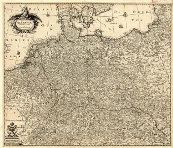
Tabula Germaniae emendata recens
1 : 2800000 Mollova mapová sbírka Visscher, Claes Jansz. Broeck, Abraham van den Visscher, Claes Janszoon
Routes des Postes et des Voitures pour les Marchandises et pour les Voyages par l'Empire dans les Principaux Etats de l'Europe
1 : 2500000 Mollova mapová sbírka Ottens, Reinier Stemmen, Jan Ottens, Josua
Germania
1 : 2500000 Mollova mapová sbírka Delisle, Guillaume Seutter, Matthäus Wolff, Jeremias
L'Allemagne
1 : 2600000 Mollova mapová sbírka Delisle, Guillaume Liébaux, Jean-Baptiste L'Isle, Guillaume de
L'Allemagne
1 : 2500000 Mollova mapová sbírka Delisle, Guillaume Covens, Johannes I
Postarum seu cursorum publicorum diverticula et mansiones per Germaniam et confin. provincias
Evropa střední Seutter, Matthäus opera et manu M. Seutteri
Postarum seu cursorum publicorum diverticula et mansiones per Germaniam et confin. provincias
Evropa střední Seutter, Matthäus opera et manu M. Seutteri
Postarum seu cursorum publicorum diverticula et mansiones per Germaniam et confin. provincias
Belgie Seutter, Matthäus opera et manu M. Seutteri
Tabula Germaniae
1 : 2780000 Evropa střední Visscher, Claes Jansz. Broeck, Abraham van den Claes Ianßen Visscher excudebat
Altgermanien, Sud-Donau-Lander, Mitte des Vten jahrhundert's.
1 : 3800000 Spruner von Merz, Karl
Tabula Germaniae emendata recens [Karte], in: Novus atlas absolutissimus, Bd. 2, S. 16.
1 Karte aus Atlas Janssonius Offizin
L'Allemagne
1 : 2500000 L'Isle, Guillaume de Dezauche
Nova Totius Germaniae Descriptio. [Karte], in: Le théâtre du monde, ou, Nouvel atlas contenant les chartes et descriptions de tous les païs de la terre, Bd. 1, S. 102.
1 Karte aus Atlas Blaeu, Willem Janszoon und Blaeu, Joan Blaeu, Willem Janszoon
Mappa Geographica exhibens Postas
Nova Totius Germaniae Descriptio. [Karte], in: Theatrum orbis terrarum, sive, Atlas novus, Bd. 1, S. 120.
1 Karte aus Atlas Blaeu, Joan Blaeu, Willem Janszoon
Nova Totius Germaniae Descriptio. [Karte], in: Novus Atlas, das ist, Weltbeschreibung, Bd. 1, S. 79.
1 Karte aus Atlas Blaeu, Joan Blaeu, Willem Janszoon
Imperium Romano-Germanicum in suos circulos electorat. et status
1 : 2700000 Evropa střední Seutter, Matthäus apud Matth. Seutter
Imperium Romano-Germanicum in suos circulos electorat. et status
1 : 2700000 Evropa střední Seutter, Matthäus Matth. Seutter
Imperium Romano-Germanicum in suos circulos electorat. et status
1 : 2700000 Evropa střední Seutter, Matthäus Matth. Seutter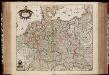
Tabula Germaniae / emendata recens per Nicolaum Joh. Piscatorem ; A. vanden Broeck sculp.
1 : 2700000 Annotatie: Linksonder: "cum privilegio; Origineel is Blad 63 in atlas factice Visscher, Claes Jansz.; Broeck, Abraham van den [Amsterdam : Nicolaes Visscher]
Eisenbahn-Karte von Deutschland
Evropa střední Rudolf Moose
Charte von Deutschland und den angränzenden Theilen der benachbarten Länder
1 : 1310000 Evropa střední Güssefeld, Franz L. Homanns Erben
Imperium Romano-Germanicum
1 : 2600000 Mollova mapová sbírka Seutter, Matthäus Seutter, Matthäus
Landtaflen
1 Atlas [von Johannes Stumpf] Christoffel Froschower, Zürych
GERMANIA
1 : 2500000 Evropa střední Delisle, Guillaume Lotter, Georg F. Tobiae Conradi Lotter
Germania
1 : 2500000 Evropa střední Delisle, Guillaume Lotter, Georg F. T. C. Lotter
Germania
1 : 2500000 Evropa střední Delisle, Guillaume Brahe, Tycho Tobiae Conradi Lotter
Germania
1 : 2500000 Evropa střední Delisle, Guillaume Brahe, Tycho in officina Tobiae Conradi Lotter
Germania
1 : 2500000 Evropa střední Delisle, Guillaume Brahe, Tycho in officina Tobiae Conradi Lotter
Germania
1 : 2500000 Evropa střední Delisle, Guillaume Brahe, Tycho in officina Tobiae Conradi Lotter