Maps of Mures
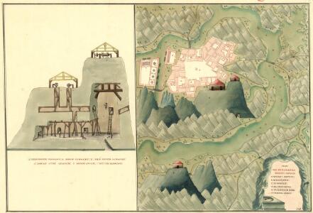
Plan des Bergwergs Weres Patack
Mollova mapová sbírka Geyer
Plan deren Bergwerg Nagiay: i Offi und Bedas
Mollova mapová sbírka Geyer
Plan des Bergwergs Igen.
Mollova mapová sbírka Geyer
Siebenbürgen
1 : 600000 Siebenbürgen
Olahfalu und Csik-Szereda.
from Spezialkarte der osterreichisch-ungarischen Monarchie.
Nyaradto und Nagy-Kend.
from Spezialkarte der osterreichisch-ungarischen Monarchie.
Szovata.
from Spezialkarte der osterreichisch-ungarischen Monarchie.
Nagy-Enyed.
from Spezialkarte der osterreichisch-ungarischen Monarchie.
Maros-Vasarhely.
from Spezialkarte der osterreichisch-ungarischen Monarchie.
Gyeres.
from Spezialkarte der osterreichisch-ungarischen Monarchie.
Torda.
from Spezialkarte der osterreichisch-ungarischen Monarchie.
Gyergyo.
from Spezialkarte der osterreichisch-ungarischen Monarchie.
Barot.
from Spezialkarte der osterreichisch-ungarischen Monarchie.
Gyulafeherva [Karlsburg].
from Spezialkarte der osterreichisch-ungarischen Monarchie.
Oláhfalu
1 : 75000 Judeţ Harghita
Torda
1 : 75000 Turda, Turda (Region)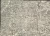
Székely Udvarhely
1 : 75000 Odorheiu Secuiesc
Maros-Ludas
1 : 75000 Luduş, Judeţ Mureş
Gyéres
1 : 75000 Câmpia Turzii, Judeţ Klausenburg
Nagy-Enyed
1 : 75000 Aiud, Judeţ Klausenburg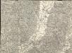
Maros Vásárhely
1 : 75000 Neumarkt, Maros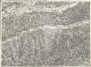
Nyárádtö
1 : 75000 Judeţ Mureş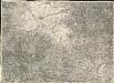
Gyergyó
1 : 75000 Gheorgheni, Judeţ Harghita
Szováta
1 : 75000 Judeţ Mureş
Erzsebetvaros [Elisabethstadt].; Spezialkarte der osterreichisch-ungarischen Monarchie.
from Spezialkarte der osterreichisch-ungarischen Monarchie. Austro-Hungarian Monarchy. Militärgeographisches Institut.,
Balazsfalva [Blasendorf].; Spezialkarte der osterreichisch-ungarischen Monarchie.
from Spezialkarte der osterreichisch-ungarischen Monarchie. Austro-Hungarian Monarchy. Militärgeographisches Institut.,
Bene [Meburg].; Spezialkarte der osterreichisch-ungarischen Monarchie.
from Spezialkarte der osterreichisch-ungarischen Monarchie. Austro-Hungarian Monarchy. Militärgeographisches Institut.,
Maros-Ludas.; Spezialkarte der osterreichisch-ungarischen Monarchie.
from Spezialkarte der osterreichisch-ungarischen Monarchie. Austro-Hungarian Monarchy. Militärgeographisches Institut.,
Szekely-Udvarhely.; Spezialkarte der osterreichisch-ungarischen Monarchie.
from Spezialkarte der osterreichisch-ungarischen Monarchie. Austro-Hungarian Monarchy. Militärgeographisches Institut.,