Maps of Carpathian Mountains
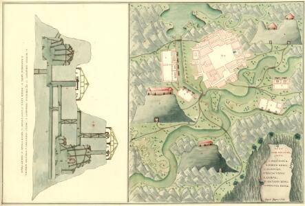
Plan von Folsi Bania
Mollova mapová sbírka Geyer
Hungary and Transilvania.
1 : 2800000 Moll, Herman, d. 1732
Hungary and Transilvania
1 : 2800000 Mollova mapová sbírka Moll, Herman Moll, Hermann
Charte von den kaiserlich Oesterreichischen Ungarischen Ländern
1 : 1240000 Maďarsko Streit, Friedrich Wilhelm im Verlage des Geograph. Instituts
Hvngariae descriptio / Wolfgango Lazio avct
1 : 1400000 1 Karte : Kupferdruck ; 32 x 49 cm Lazius, Wolfgang [Verlag nicht ermittelbar]
Ungarn und ein Theil von Siebenbürgen
Hand-Atlas über alle Theile der Erde nach dem neuesten Zustande und über das Weltgebäude Stieler, Adolf bei Justus Perthes
Ungarn und ein Theil von Siebenbürgen
Stieler's Hand-Atlas Stieler, Adolf bei Justus Perthes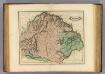
Hungary, Transilvania &c.
1 : 1470000 Lizars, Daniel
Ungarn und ein Theil von Siebenbürgen
Hand-Atlas über alle Theile der Erde nach dem neuesten Zustande und über das Weltgebäude Stieler, Adolf bei Justus Perthes
Uhry
1 : 1870000 Maďarsko
Uhry
1 : 1870000 Maďarsko
Uhry
1 : 1870000 Maďarsko
Hvngariae descriptio
1 : 3400000 Uhersko Lazius, Wolfgang Ortelius, Abraham A. Ortelius
Novissima regni Hungariae potamographica et telluris productorum tabula
1 : 991000 Maďarsko Junker, Christoph Joh. Matth. Korabinsky
Ungarn, Siebenburgen, Slavonien, Kroatien.
1 : 1850000 Stieler, Adolf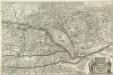
Neue Land Tafel von Hungarn
1 : 1100000 Mollova mapová sbírka Sandrart, Jakob von Sandrart, Jacob von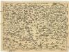
Regni Hvngariae
1 : 4000000 Uhersko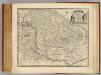
Hungary, Transilvania.
1 : 1650000 Bowen, Emanuel
Charte von den kaiserlich oesterreichischen ungarischen Ländern
1 : 1230000 Maďarsko Streit, Friedrich Wilhelm im Verlage des Geograph. Instituts
Hvngaria seu Tvrcia in Octo Capitaneatus diuisa
1 : 4300000 Mollova mapová sbírka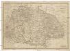
Ungarn sam[m]t der vereinigten Ländern und Siebenbürgen
Maďarsko Hocke, Jan Kapras, Jan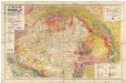
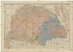
A Magyar birodalom és a szomszédos országok határos területeinek földtani térképe
1 : 900000 Maďarsko Lóczy, Lajos Papp, Károly Magyar földrajzi társaság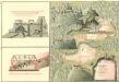
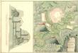
Plan des Hoch Geföls Korpsona
Mollova mapová sbírka Geyer
Novissima et Accuratissima Totius Hungariae Tabula
1 : 1400000 Mollova mapová sbírka Duval, Pierre Danckerts, Justus
Länder der Ungarischen Krone: Ungarn, Siebenbürgen, Slavonien und ein Theil von Kroatien
Handatlas über alle Theile der Erde und über das Weltgebäude Stieler, Adolf Justus Perthes
Die Münzkammer-Gebiete Ungarns bis 1395
Ungarn Münzwesen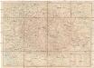
Magyarország úthálózatának térképe
1 : 1300000 Maďarsko Homolka, Josef Eggenberger féle könyvkereskedés (Hofmann Alfréd)
Charte von den Kaiserlich Oesterreichischen Ungarischen Ländern
1 : 1200000 entworfen u. gezeichnet von F. W. Streit Weimar : Verlag des Geograph. Instituts