Maps of Western Slovakia

Vermehrte und Verbesserte Landkarten des Königreichs Ungarn :
1 : 500000 Mollova mapová sbírka Stier, Martin Böner, Johann-Alexander Endter, Martin
Juhovýchodné Moravskoslezsko, Západné Slovensko
1 : 300000 Bratislava (Slovensko) Fastr Eduard
Braun: Autová mapa I-III (Slovensko, Podkarpatská Rus)

Bez titulu: mapy slovenských krajů
Karte der Kaiser Ferdinands-Nordbahn
Brno-oblast (Česko) R. v. Waldheim
Stolice Prešpurk a Nitra
Bratislava, Nitra, ethnische Gruppe
Comitat Pressburg
1 : 280000 Bratislava-oblast (Slovensko)
Comitat Pressburg
1 : 300000 Bratislava (Slovensko : oblast)
Mappa Comitatvs Posoniensis
1 : 250000 Mollova mapová sbírka Bel, Matej Nicolaï, Georg David Christoph Bel, Matej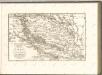

Lundenburg 133, uit: Special-Karte von Mittel-Europa / nach amtlichen Quellen bearbeitet von W. Liebenow
1 : 300000 titelvariant: W. Liebenow's Mittel-Europa; Annotatie: Titel boven de bladen: W. Liebenow's Mittel-Europa Johannes Wilhelm Liebenow 1822-1897 Frankfurt a. M. : Ludwig Ravenstein
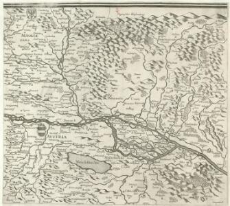
Mappa Comitatvs Nitriensis :
1 : 170000 Mollova mapová sbírka Mikoviny, Sámuel Nicolaï, Georg David Christoph
Mappa Comitatvs Posoniensis
1 : 240000 Mollova mapová sbírka Nicolaï, Georg David Christoph
Poszony vármegye térképe
1 : 300000 Bratislava (Slovensko : oblast) Kogutowicz, Manó Magyar Földrajzi Intézet
COMITATVS POSONIENSIS Germanis PRESBVRG dicti Delineatio Geographica
1 : 113000 Bratislava-oblast (Slovensko) Mikoviny, Sámuel curantibus] Homannianis [Heredibus
Mappa Comitatus Posoniensis Accuratione Astronomico-Geometrica concinnata opera.
1 : 140000 Mollova mapová sbírka Mikoviny, Sámuel Straub, Paul
Generalkarte von Zentraleuropa

Wien 147, uit: Special-Karte von Mittel-Europa / nach amtlichen Quellen bearbeitet von W. Liebenow
1 : 300000 titelvariant: W. Liebenow's Mittel-Europa; Annotatie: Titel boven de bladen: W. Liebenow's Mittel-Europa Johannes Wilhelm Liebenow 1822-1897 Frankfurt a. M. : Ludwig Ravenstein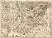
Tabula Generalis Marchionatus Moraviae in sex circulos divisae
1 : 183000 Mollova mapová sbírka Müller, Johann Christoph Gastl, Jan Jiří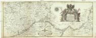
Mappa des March-Flus
1 : 160000 Bečva, řeka (Česko) Linck, Norbert Wenzl von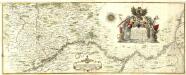
Mappa des March-Flus
Mollova mapová sbírka Linck, Václav
Uibersichts Karte der projectirten Tracen, der Wien-Raaber Eisenbahn sammt Nebenzweigen
1 : 430000 Győr (Maďarsko) M. Schönerer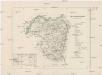
Ober-Neutraer Comitat
1 : 280000 Nitra-oblast (Slovensko)
Bratislava okolie

C. Nitriensis. Tab. II
Slowakei Komitat Neutra
Comitat Wieselburg
1 : 280000 Mosonmagyaróvár (Maďarsko)
Comitat Wieselburg
1 : 280000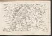
C. Posoniensis. Tab. I
Slowakei Komitat Preßburg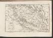
C. Posoniensis. Tab. II
Slowakei Komitat Preßburg