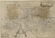
Maps of Southeast
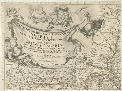
Augustissimo Romanor. Imperatori Iosepho I. Hungaria Regi Invictissimo Mappam Hanc Regni Hungariae
1 : 540000 Mollova mapová sbírka Müller, Johann Christoph
Hydrographische Karte des Flussgebietes zwischen Moldau Donau March
1 : 1000000 Dunaj
Partie Du Cercle D'Austriche Sçavoir L'Archiduché D'Austriche Divisé en Haute et Basse [Karte], in: Atlas nouveau, contenant toutes les parties du monde [...], Bd. 1, S. 259.
1 Karte aus Atlas Sanson, Nicolas Jaillot, Alexis Hubert und Mortier, Pieter
Eisenbahnkarte von Böhmen Mähren u. Schlesien
1 : 1200000 Evropa střední Ed. Hölzel
Blatt II, uit: Geologische Übersichts-Karte der Österreichisch-Ungarischen Monarchie / nach den Aufnahmen der K.K. Geologischen Reichsanstalt bearb. von Franz Ritter von Hauer ; gezeichn. von Eduard Jahn
1 : 576000 Annotatie geografische gegevens: Gebaseerd op veldwerk in de jaren 1850 tot 1865 Hauer, Franz Ritter von; Jahn, Eduard; Kaiserlich-Königliche Geologische Reichsanstalt, Wenen Wien : Beck
Českomoravská dráha Plzeň-Brno s přípojkami jest významu celostátního a mezinárodního
Brno (Česko) Vojenský zeměpisný ústav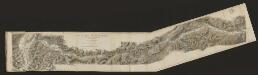
Austria Archiducatus [Karte], in: Gerardi Mercatoris et I. Hondii Newer Atlas, oder, Grosses Weltbuch, Bd. 1, S. 334.
1 Karte aus Atlas Mercator, Gerhard und Hondius, Jodocus Jansson, Jan
Geognostische Karte des Beckens von Wien und der Gebirge, die dasselbe umgeben
1 : 435000 Dolní Rakousko (Rakousko) Partsch, Paul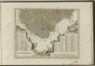
Übersichtskarte der Protektoratsbahnen Böhmen und Mähren
1 : 400000 Protektorát Čechy a Morava Ministerstvo dopravy
Morava a Rakouské Slezsko]
1 : 25000 Mollova mapová sbírka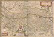
Austria Archiducatus [Karte], in: Novus atlas absolutissimus, Bd. 2, S. 276.
1 Karte aus Atlas Janssonius Offizin
Austria Archiducatus [Karte], in: Le théâtre du monde, ou, Nouvel atlas contenant les chartes et descriptions de tous les païs de la terre, Bd. 1, S. 245.
1 Karte aus Atlas Blaeu, Willem Janszoon und Blaeu, Joan Blaeu, Willem Janszoon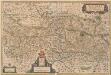
Austria Archiducatus [Karte], in: Novus Atlas, das ist, Weltbeschreibung, Bd. 1, S. 216.
1 Karte aus Atlas Blaeu, Joan Blaeu, Willem Janszoon
Geognostische Karte des Beckens von Wien und der Gebirge, die dasselbe umgeben
1 : 450000 Partsch, Paul [s.n.]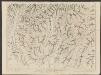
Austria Archiducatus [Karte], in: Theatrum orbis terrarum, sive, Atlas novus, Bd. 1, S. 127.
1 Karte aus Atlas Blaeu, Joan Blaeu, Willem Janszoon
Program staveb a úprav státních i nestátních silnic a mostů r. 1939
Protektorát Čechy a Morava Zprávy veřejné služby technické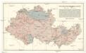
Přehledná úpatnicová mapa 1:1,000.000
1 : 1000000 Protektorát Čechy a Morava KČT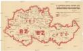
[Protektorát Čechy a Morava - výdej a odběr pohonných látek]
Protektorát Čechy a Morava
Vollständige General Posten- und Straßen-Karte des Königreichs Ungarn ; Ungarns Tittelkupfer sammt Abbildung der Städtn Preßburg, Pesth und Ofen. Gränze zu Preussen, Schlesien, Böhmen, Mähren und Baiern
Ungarn Verkehrsweg
Strategische Situation der beiderseitigen Armeen am: 18. Juni, 26. Juni Abends, 27. Juni Abends, 28. Juni Abends, 30. Juni Abends, 2. Juli Abends
Česko
AVSTRIA | ARCHIDVCATVS
auctore Wolfgango Lazio. [Amsterdam : Joan Blaeu]
Kreis-, Gerichts-, Völker-, Telegrafen-, Eisenbahn- und Post Karte des Erzherzogthumes Österreich und Herzogthumes Salzburg
1 : 850000 Rakousko Raffelsperger, Franz Franz Raffelsperger
Karte des Erzherzogthumes Österreich mit Salzburg
1 : 850000 Rakousko Raffelsperger, Franz Rumpold, F. im typographischen Landkarten-Verlage
Partie du Royaume de Hongrie, vers le Septentrion, et l'Occident
1 : 680000 Mollova mapová sbírka Coronelli, Vincenzo Maria Nolin, Jean Baptiste
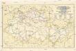
Hydrographische Karte der Markgrafschaft Mähren
1 : 432000 Morava (Česko) Mährischer Landes-Ausschuss
Austria archiducatus. [Karte], in: Gerardi Mercatoris Atlas, sive, Cosmographicae meditationes de fabrica mundi et fabricati figura, S. 403.
1 Karte aus Atlas Mercator, Gerhard Montanus, Petrus
Flusskarte für die Projektirung der Ent- und Bewässerung der March und Thaya Gebiete : auf Anordnung Seiner Excellenz des Hrr. k.k. Ackerbau-Ministers Hieronymus Grafen zu Mannsfeld
Hobohm, H. Stockinger & Morsack
Avstria Archidvcatvs
1 : 660000 Mollova mapová sbírka Lazius, Wolfgang Schenk, Peter I