Maps of Romania
Le Royaume De Hongrie
Mollova mapová sbírka Placide de Sainte-Hélène Berey, Charles Amadeus de Duval, Pierre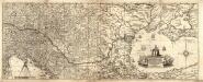
Neűe Ungarisch- und Türckische Grosse Land-Charte
1 : 2100000 Mollova mapová sbírka Hoffmann, Johann Pfann, Wilhelm Hoffmann, Johann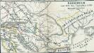
Pannonien zur Zeit des Svatopluk 895
1 : 15000000 Pannonien Swatopluk I., Mähren, Herzog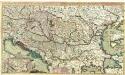
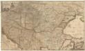
Theatre de la Guerre en Hongrie, Bosnie, Servie, et Tartarie Crimee, en il Grandes Feuilles
1 : 2000000 Mollova mapová sbírka Briffaut, Etienne Briffaut, Etienne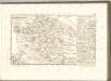
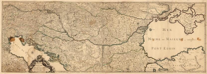
Novissima tabula regni Hungariae et regionum quondam ei unitarum ut Transilvaniae, Valachiae, Moldaviae, Serviae, Romaniae, Bulgariae, Bessarabiae, Croatiae, Bosniae, Dalmatiae, Slavoniae, Morlachiae et reipublicae Ragusanae : accedit pars magna dominii Veneti [...]
1 : 2000000 auctore Reinier & Josua Ottens geographe Amstelodamensi J. Keyser sculpsit Te Amsterdam : by Reinier & Iosua Ottens [...]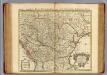
Hongrie.
1 : 2550000 L'Isle, Guillaume de, 1675-1726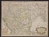
Carte de la Hongrie et partie septentrionale de la Turquie
Ungarn, Osmanisches Reich L'Isle, Guillaume de
Daciarum, Moesiarumque, Vetus Descriptio. [Karte], in: Theatrum orbis terrarum, S. 505.
1 Karte aus Atlas Ortelius, Abraham Vrients, Jan Baptista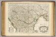
Hongrie, pays qui en dependoient autrefois.
1 : 2550000 L'Isle, Guillaume de, 1675-1726
A Duna
1 : 4500000 Dunaj (řeka) Homolka, Josef Posner Károly Lajos és fia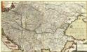
Neu und Accurat vefasste General Post Land-Karte des sehr grossen Welt berühmten Konig-Reichs Hungarn
1 : 1400000 Mollova mapová sbírka Lidl, Johann Jakob Lidl, Johann Jacob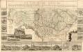
Le Cours Du Danube
Mollova mapová sbírka Fer, Nicolas de Fer, Nicolas de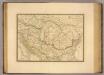
Dacie ancienne, Pannonie, Illyrie, Moesie.
1 : 2900000 Picquet, C.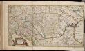
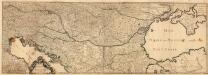
Totius Regni Hungariae maximaeque partis Danubii fluminis, una cum adjacentibus et finitimis regionibus novissima delineatio / per Nicolaum Visscher
1 : 2000000 Annotatie: Origineel is Blad 130 in atlas factice; Annotatie geografische gegevens: Met 2 schaalstokken Nicolaes Jansz. Visscher jr. 1649-1702 [Amsterdam : per Nicolaum Visscher]
Hungariae
1 : 2600000 Balkánský poloostrov Hase, Johann Matthias Homannianos Heredes
HUNGARIAE ampliori significatu et veteris vel Methodicae, complexae REGNA
1 : 2600000 Bosna Hase, Johann Matthias curantibus Homannianis Heredibus
Hungariae
1 : 2600000 Balkánský poloostrov Hase, Johann Matthias Homannianis Heredibus
Ungarn in seinen kirchlichen Verhältnissen vom Anfang des XIV Jahrh. bis zur Reformation
1 : 3700000 Ungarn Kirchengeschichte
Tabula Hungaria et regionum, quae praeterea ab ea dependent
1 : 2100000 Maďarsko Delisle, Guillaume Lotter, Georg F. T. C. Lotter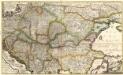
Accurate Landkarte die Königreiche
1 : 1400000 Mollova mapová sbírka Lidl, Johann Jakob Lidl, Johann Jacob
Accurate Landkarte die Königreiche
1 : 1400000 Mollova mapová sbírka Lidl, Johann Jakob Lidl, Johann Jacob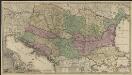
Novissima tabula regni Hungariae et regionum quondam ei unitarum ut Transilvaniae, Valachiae, Moldaviae, Serviae, Romaniae, Bulgariae, Bessarabiae, Croatiae, Bosniae, Dalmatiae, Slavoniae, Morlachiae et reipublicae Ragusanae : accedit pars magna dominii Veneti [...]
1 : 2000000 auctore Reinier & Josua Ottens geographe Amstelodamensi J. Keyser sculpsit Te Amsterdam : by Reinier & Iosua Ottens [...]
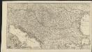
Accurate Landkarte die Königreiche Ober- und Nieder- Hungarn, Slavonien, Croatien, Dalmatien, Bosnien, Servien, Bulgarien, und Romanien, das Groß Fürstenthum Siebenbürgen, die Fürstenthümer Moldau, Wallachen, Bessarabien, die Oczakowisch- und Crimische Tartaren, die pohlnische Provinz Podolien, wie auch ein Theil von Ukranien, und übrige angränzende Ländern vorstellend
1 : 1430000 Besarábie (Moldavsko a Ukrajina) Lidl, Johann Jakob Joh. Jacob Lidl
Ungarn u. seine Nebenländer vom Anfang des XIII Jahrhunderts bis zur Schlacht bei Mohacs 1526
1 : 3700000 Ungarn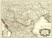
Carte de la Hongrie
1 : 2500000 Mollova mapová sbírka Delisle, Guillaume Liébaux L'Isle, Guillaume de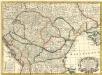
Tabula Hungaria
1 : 2500000 Mollova mapová sbírka Delisle, Guillaume Seutter, Matthäus Wolff, Jeremias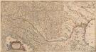
Totius Regni Hungariae, Maximaeque Partis Danubii Fluminis, una cum adjacentibus et finitimis Regionibus Novissima Delineatio [Karte], in: Novus atlas absolutissimus, Bd. 2, S. 293.
1 Karte aus Atlas Janssonius Offizin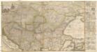
Accurate Landkarte die Königreiche Ober- und Nieder- Hungarn, Slavonien, Croatien, Dalmatien, Bosnien, Servien, Bulgarien und Romanien, das Gross Fürstenthum Siebenbürgen, die Fürstenthümer Moldau, Wallachen, Bessarabien, die Oczakowisch- und Crimische Tartaren, die Pohlnische Provinz Podolien, wie auch ein Theil von Ukranien, und übrige angränzende Ländere vorstellend
1 : 1430000 Besarábie (Moldavsko a Ukrajina) Lidl, Johann Jakob Joh. Jacob Lidl