Maps of Umbria

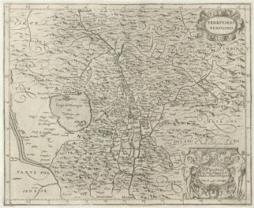
Territorio Pervgino
1 : 200000 Mollova mapová sbírka Magini, Fabio Magini, Fabio
Patrimonio di S. Pietro Sabina, et Ducato di Castro
1 : 210000 Mollova mapová sbírka Magini, Giovanni Antonio Magini, Fabio
Viaggio da Ancona e da Fano per Foligno a Roma
1 : 1200000 Ancona (Itálie)
Karte von Latium
Lazio (Itálie)
Latium
Lazio (Itálie) E. [sic] Tempsky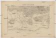
Karte von Latium
Lazio (Itálie) F. Tempsky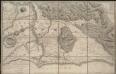
Plan topographique de la campagne de Rome
1 : 130000
Latium Vetus

A plan of the environs of ancient Rome
1 : 412000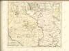
Perusini agri; exactißima novißimaque descriptio [Karte], in: Theatrum orbis terrarum, S. 223.
1 Karte aus Atlas Ortelius, Abraham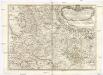
Tavola generale della provincia dell'Vmbria
1 : 250000 Umbrie (Itálie) Moroncelli, Silvester Amanzio De Rossi, Domenico Domenico de Rossi
Territorio Perugino [Karte], in: Novus atlas absolutissimus, Bd. 5, S. 163.
1 Karte aus Atlas Janssonius Offizin

TERRITORIO | PERVGINO.
[Amsterdam : Joan Blaeu]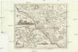
Campagna di Roma
Řím-oblast (Itálie) Lotter, Tobias Conrad Pronti, Domenico presso Piale neg. di stampe
Territorio Perugino [Karte], in: Le théâtre du monde, ou, Nouvel atlas contenant les chartes et descriptions de tous les païs de la terre, Bd. 3, S. 195.
1 Karte aus Atlas Blaeu, Willem Janszoon und Blaeu, Joan Blaeu, Willem Janszoon
Territorio Perugino [Karte], in: Theatrum orbis terrarum, sive, Atlas novus, Bd. 3, S. 167.
1 Karte aus Atlas Blaeu, Joan Blaeu, Willem Janszoon
Territorio Perugino [Karte], in: Novus Atlas, das ist, Weltbeschreibung, Bd. 3, S. 185.
1 Karte aus Atlas Blaeu, Joan Blaeu, Willem Janszoon

Territorio Di Orvieto [Karte], in: Novus Atlas, das ist, Weltbeschreibung, Bd. 3, S. 188.
1 Karte aus Atlas Blaeu, Joan Blaeu, Willem Janszoon
Territorio Di Orvieto [Karte], in: Theatrum orbis terrarum, sive, Atlas novus, Bd. 3, S. 170.
1 Karte aus Atlas Blaeu, Joan Blaeu, Willem Janszoon
Territorio Di Orvieto [Karte], in: Le théâtre du monde, ou, Nouvel atlas contenant les chartes et descriptions de tous les païs de la terre, Bd. 3, S. 198.
1 Karte aus Atlas Blaeu, Willem Janszoon und Blaeu, Joan Blaeu, Willem Janszoon
Territorio Di Orvieto. [Karte], in: Novus atlas absolutissimus, Bd. 5, S. 160.
1 Karte aus Atlas Janssonius Offizin
TERRITORIO | DI | ORVIETO.
[Amsterdam : Joan Blaeu]
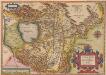
[Roma Vetus, Athenae, Urbs cum adjacentibus regionibus, Hierosolyma]
Schul-Atlas der alten Welt bei Justus Perthes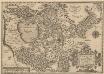
Perusini agri; exactißima novißimaque descriptio [Karte], in: Theatrum orbis terrarum, S. 318.
1 Karte aus Atlas Ortelius, Abraham Vrients, Jan Baptista
Territorii Romani Descrip. [Karte], in: Theatrum orbis terrarum, S. 85.
1 Karte aus Atlas Ortelius, Abraham
Ducatus Bracciani et Anguillariae Comitatus, Olim Sabatia. [Karte], in: Novus atlas absolutissimus, Bd. 5, S. 171.
1 Karte aus Atlas Janssonius Offizin