Maps of Primorje-Gorski Kotar County
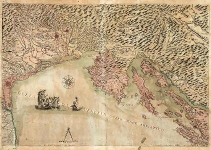
Golfo di Venetia Overo Mare Adriatico
Mollova mapová sbírka Scolari, Stefano Lovisa, Domenico
F.7. Triest, uit: [Übersichtskarte von Europa 1:750.000]
1 : 750000 Wien : K.u.K. Militärgeographisches Institut
Triest
1 : 750000 Benátky (Itálie) K. u. k. Militärgeographisches Institut
Pola, Zara, Comacchio
1 : 750000 Comacchio (Itálie) Mach, O. K. u. k. Militärgeographisches Institut
Pola, Zara, Comacchio
1 : 750000 Zadar (Chorvatsko : oblast) K. k. militär. geografisches Institut
Pola, Zara, Comacchio
1 : 750000 Comacchio (Itálie) K. k. militär-geographisches Institut
Übersichtskarte von Mittel - Europa

Karstia, Carniola, Histria et Windorvm Marchia
1 : 620000 Mollova mapová sbírka Mercator, Gerhard Schenk, Pieter Schenk, Peter I
Carniola Karstia Histria et Windorvm Marchia
1 : 660000 Mollova mapová sbírka Valvasor, Janez Vajkard Trost, Andreas Endter, Wolfgang Moritz
Ducatus Carnioliae Tabula
1 : 725000 Mollova mapová sbírka Pfeffel, Johann Andreas
Ducatus Carnioliae Tabula
1 : 725000 Mollova mapová sbírka Reiffenstuel, R.
Karstia, Carniola, Histria et Windorvm Marchia
1 : 620000 Mollova mapová sbírka Mercator, Gerhard Janssonius, Johannes Janssonius, Johannes I
Bez titulu: Istrie a Dalmatské pobřeží

XII, uit: General-Karte des oesterreichischen Kaiserstaates mit einem grossen Theile der angrenzenden Länder / durch Josef Scheda ... bearb. und hrsg
1 : 576000 Annotatie geografische gegevens: Maatstokken: oesterreichische Meilen, geografische oder deutsche Meilen, preussische Meilen, türkische Berri, französische Lieues, russische Werste; Maatstok per blad: wiener Klafter, öster. Meilen; Blad XIX: statistische en taalkundige informatie; Blad XIX: legenda [Wien : K.K. Militärisch-Geografisches Institut]
Sheet XII: Karte Des Oesterreichischen Kaiserstaates.
1 : 576000 Scheda, Josef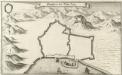
Grondtris der Statt Zeng
Mollova mapová sbírka Merian, Matthaeus Merian, Matthäus
Goritiae, Karstii, Chaczeolae, Carniolae, Histriae, Et Windorum Marchae Descrip. [Karte], in: Theatrum orbis terrarum, S. 281.
1 Karte aus Atlas Ortelius, Abraham Vrients, Jan Baptista
Lo Stato Veneto da terra diviso nelle sue provincie, quarta parte che compren de porzioni del Dogado e dell' Istria.
1 : 536000
Oesterreichische Riviera

Goritiae, Karstii, Chaczeolae, Carniolae, Histriae, Et Windorum Marchae Descrip. [Karte], in: Theatrum orbis terrarum, S. 186.
1 Karte aus Atlas Ortelius, Abraham
Jonction de la mer Adriatique á la Culpa
1 : 150000 Jaderské moře-oblast
Carta del litorale Austriaco
Istrijský poloostrov (Slovinsko a Chorvatsko) Schwarzer von Heldenstamm, Ernst
Carnioia
Mollova mapová sbírka Hoffmann, Johannes Hoffmann, Johann
Istrie
1 : 750000 Machát, František c. a k. voj. zeměpisný ústav
Die adriatische Küste von Pola bis Zara
1 : 900000 Kroatien Adriaküste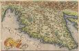
Histriae tabula [Karte], in: Theatrum orbis terrarum, S. 262.
1 Karte aus Atlas Ortelius, Abraham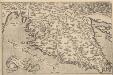
Histriae tabula [Karte], in: Theatrum orbis terrarum, S. 357.
1 Karte aus Atlas Ortelius, Abraham Vrients, Jan Baptista
Tabula DUCATUS CARNIOLIAE VINDORUM MARCHIAE et HISTRIAE
1 : 520000 Cirknické jezero (Slovinsko) Homann, Johann Baptist Valvasor, Janez Vajkard â Io. Bapt. Homanno
Tabula ducatus Carnioliae Vindorum Marchiae et Histriae
1 : 510000 Cirknické jezero (Slovinsko) Homann, Johann Baptist Valvasor, L. B. â Io. Bapt. Homanno