Maps of Piemonte

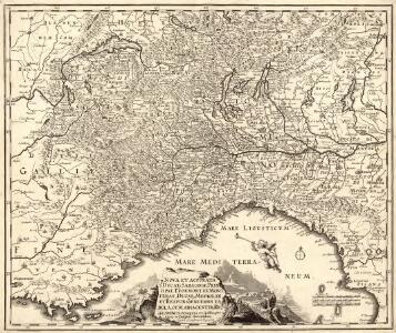
Nova et accurata Ducatus Sabaudiae, Principat. Pedemont. et Montferat., Ducatus Mediolan. et Reipub. Genuensis tabula
1 : 1200000 Mollova mapová sbírka Sandrart, Jakob von Sandrart, Jacob von
Charte des Koenigreichs Sardinien
1 : 1460000 Piemonte (Itálie) Mollo, Tranquillo bey Tranquillo Mollo
Charte des Koenigreichs Sardinien
1 : 1460000 Piemonte (Itálie) Mollo, Tranquillo bey Tranquillo Mollo
Strassen-Karte der westlichen Alpen
1 : 700000 Západní Alpy Oesterreichischen Generalquartiermeisterstabs
Strassen-Karte der westlichen Alpen
1 : 700000 Západní Alpy K. u. k. Militärgeographisches Institut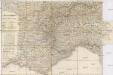
Strassen-Karte der westlichen Alpen
1 : 700000 Západní Alpy K. u. k. Militärgeographisches Institut
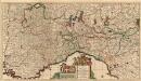
Partie occidentale de la Lombardie et pays circonvoisins, ou sont les etats de Savoye, Piémont, Milan, Genes, Plaisance &c
1 : 650000 Janov (Itálie) Robert de Vaugondy, Didier Delahaye, Guillaume-Nicolas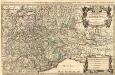
Les Montagnes des Alpes ou sont remarqués Les Passages France en Italie, Le Duché de Milan, et Les Estats du Duc de Savoye. &c.
1 : 730000 Mollova mapová sbírka Sanson, Guillaume Jaillot, Alexis Hubert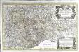
Les montagnes des Alpes ou sont remarqués les passages de France en Italie, le duché de Milan, et les estats du duc de Savoye &c
1 Karte auf 2 Blatt : Kupferdruck ; 52 x 85 cm Sanson chez Jean Cóvens et Corneille Mortier géographes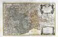
Les montagnes des Alpes ou sont remarqués les passages de France en Italie, le duché de Milan, et les estats du duc de Savoye &c
1 Karte auf 2 Blatt : Kupferdruck ; 52 x 85 cm Jaillot; Sanson chez H. Iaillot joignant les grands Augustins aux deux globes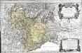
Les montagnes des Alpes ou sont remarqués les passages de France en Italie, le duché de Milan, et les estats du duc de Savoye &c
1 Karte auf 2 Blatt : Kupferdruck ; 53 x 86 cm Jaillot; Sanson chez H. Iaillot joignant les grands Augustins aux deux globes
Schweizerische Eidsgenossenschaft
1 : 1250000 1 Karte [Verlag nicht ermittelbar], [St. Gallen]
Das Festland Sardinien

Ancient Italy I.
1 : 1770000 Society for the Diffusion of Useful Knowledge (Great Britain)
Italy I.
1 : 1770000 Society for the Diffusion of Useful Knowledge (Great Britain)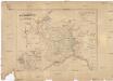
Das Festland Sardinien
1 : 1050000 Piemonte (Itálie) Joh. Prasch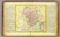
Etats du Roy de Sardaigne.
1 : 1400000 Clouet, J. B. L. (Jean-Baptiste Louis), b. 1730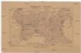
Severní Italie [sic]
Itálie severní Lotter, Tobias Conrad Wagner, Jan Eduard Jaroslav Pospíšil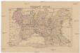
Severní Italie [sic]
Itálie severní Lotter, Tobias Conrad Wagner, Jan Eduard Jaroslav Pospíšil
Carte Générale des Marches, Mouvemens et Opérations executés pendant la Campagne des l'an VIII
Sedes Belli in Italiâ
1 : 870000 Mollova mapová sbírka Danckerts, Justus Danckerts, Justus
De Middellandsche Zeekust (Marseille-Genuae-Viareggo)
1 : 1800000 Annotatie: Vrijgegeven door W.B.N. 20.5.'44 Den Haag : Kompas
Alta Lombardia, e Stati ad essa Circonuicini
1 : 880000 Mollova mapová sbírka Cantelli, Giacomo Widman, Giorgio De Rossi, Giovanni Giacomo
N. parts of Italy.
1 : 2750000 Bowen, Emanuel
<<[Die>> Schweitz]
1 : 4000000 1 Karte [Johann Ulrich Müller] [Andrea], [Frankfurt a. M.]
Padi Fluvii Tractvs integer
1 : 2000000 Mollova mapová sbírka
Italy 1.
1 : 1774080 Letts, Son & Co.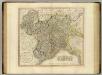
Piedmont, Savoy, Milan, Genoa.
1 : 760000 Cary, John, ca. 1754-1835
Kriegstheater oder Grænzkarte zwischen Frankreich und Italien
1 Karte : Kupferdruck ; 48 x 58 cm Walch; Will zu haben bey Ioh. Walch im Willischen Kunstverlag