Maps of Brescia

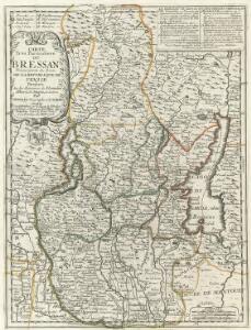
Carte Tres Particuliere du Brassan Faisant partie des Etats de la Republique de Venise
1 : 370000 Mollova mapová sbírka Nolin, Jean-Baptiste Nolin, Jean Baptiste
Carte particulière du Bressan faisant partie des états de la république de Venise : levée par ordre exprès à l'usage des armées en Italie &c
1 : 220000 par le Sr Sanson, Geograph. du Roy A Amsterdam : chez Pierre Mortier
Carte Particuliere Du Bressan Faisant Partie des Etats dela Republique De Venise Leveé Par Ordre Exprès á L'Usage des Armées En Italie &c. [Karte], in: Atlas nouveau, contenant toutes les parties du monde [...], Bd. 2, S. 166.
1 Karte aus Atlas Sanson, Nicolas Jaillot, Alexis Hubert und Mortier, Pieter
TERRITORIO | di | BRESCIA | et di | CREMA
Apud Guiljelmum | et Joannem Blaeu
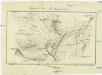
Verona
1 : 200000 1 Karte entworfen und bearb. von Woerl, gestochen unter seiner Leitung 1835 ; Lithographie von B. Herder Herder, Freiburg im Breisgau
Carta geologica delle provinicie Lombarde
1 : 172800 Ostblatt Curioni, G. Hoepli
Verona
1 : 200000 Woerl, Joseph Edmund ; Herder, Bartholomäus Herder

Blatt XXV: Höhen der vorzüglichsten Punkte, uit: Topographische Karte der Schweiz / vermessen und hrsg. ... unter Aufsicht des Generals G.H. Dufour
1 : 100000 Annotatie: Met plaatsnamenregister (bl. V), bladwijzer (bl. XXI) en hoogteregister (bl. XXV); Voor aanwezige bladen zie overzichtsblad Dufour, G. H. [Bern : Eidg. Topogr. Bureau]
Topographische Karte der Schweiz (Dufour-Karte): Den Kanton Zürich betreffende Blätter: Blatt XXV: Bergamo; Liste mit Höhenangaben (Höhen der vorzüglichsten Punkte)
1 : 100000 Leitung: Dufour, Guillaume-Henri (1787-1875), General, Politiker, Ingenieur und Kartograf, von Genf; Eidgenössisches Topographisches Bureau, in Genf Stich: Stempelmann, J. (1835-1887)
Carte Nouvelle Du Bergamasco Faisant Partie des Etats de la Republique de Venise [...] [Karte], in: Atlas nouveau, contenant toutes les parties du monde [...], Bd. 2, S. 168.
1 Karte aus Atlas Sanson, Nicolas Jaillot, Alexis Hubert und Mortier, Pieter
Nova et Esatta Descrizione Topografica della Riviera di Salo posta in Luce da un suo Cittadino dilettante
Mollova mapová sbírka Filosi, Giuseppe
Storo.
from Spezialkarte der osterreichisch-ungarischen Monarchie.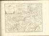

Carte d'une Partie du Mantouan, du Veronois, et des Campanems de l'Armée Imperiale
Mollova mapová sbírka Rebein, J. D.
Tione und M.Adamello.
from Spezialkarte der osterreichisch-ungarischen Monarchie.
Karte der Adamello- und Presanella-Gruppe
1 : 50000 Alpy italské (pohoří) Deutscher u. Oesterreichischer Alpen Verein
Plan der Gegend am obern Mincio
1 : 20000 Gardské jezero-oblast (Itálie)
Plan des Schlachtfeldes von Custozza am 24. Juni 1866
1 : 20000 Blatt 2 [k.k. Generalstabs-Bureau für Kriegsgeschichte]
Plan des Schlachtfeldes von Custozza am 24. Juni 1866
1 : 20000 Blatt 1 [k.k. Generalstabs-Bureau für Kriegsgeschichte]
Schlacht bei Solferino
Gegend bei Monzambano
Monzambano (Itálie) Mathievich, Alexander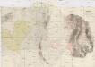
Gegend zwischen Lonato, Castiglione, Montechiari und Castenedolo
1 : 13500 Castenedolo (Itálie)

Landesstrich zwischen der Chiese und der Etsch 1837
1 : 21600 Blatt 3 [s.n.]

Landesstrich zwischen der Chiese und der Etsch 1837
1 : 21600 Blatt 4 [s.n.]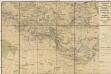
Gegend zwischen Volta, Guidizzolo, Solferino, Cavriana und Monzambano zum Behuf der Manoeuvrir-Rayons der Division des F.M.L. Baron Paumgarten im Jahre 1834
1 : 31500 Cavriana (Itálie)